Calcasieu River
| Calcasieu River | |
| River | |
| Country | United States |
|---|---|
| State | Louisiana |
| City | Lake Charles, LA |
| Source | Confluence of bayous/forests |
| - location | Vernon Parish, Louisiana, United States |
| Mouth | Gulf of Mexico |
| - location | Cameron, Cameron Parish, Louisiana, United States |
| Length | 200 mi (322 km) |
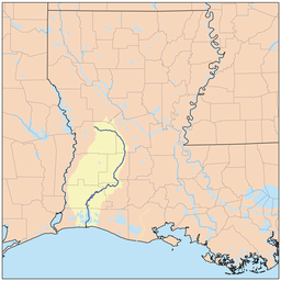 Calcasieu River watershed
| |
The Calcasieu River (/ˈkælkəˌʃuː/ KAL-kə-SHOO) is a river on the Gulf Coast in southwestern Louisiana. Approximately 200 miles (320 km) long,[1] it drains a largely rural area of forests and bayou country, meandering southward to the Gulf of Mexico. The name "Calcasieu" comes from the Native American Atakapa language katkosh, for "eagle", and yok, "to cry".

The Calcasieu rises in Vernon Parish, north of Leesville, and flows initially southeast, passing through the Kisatchie National Forest southwest of Alexandria. It then turns southwest, flowing past Oakdale and Lake Charles, the largest city on the river. It enters the north end of the brackish Calcasieu Lake, an estuary on the Gulf of Mexico approximately 10 miles (16 km) southwest of Lake Charles. The lake, which is referred to by locals as "Big Lake", is connected by a 5-mile (8 km) channel to the gulf on the south end. The lower portion of the river south of Lake Charles is paralleled by a navigable canal which connects to the Gulf Intracoastal Waterway.
In the early 19th century, the area of present-day Louisiana and Texas west of the Calcasieu River extending roughly north-south to the Arroyo Hondo in Natchitoches Parish and east of the Neches River was disputed between the United States and Mexico. The dispute arose from differing interpretations of the western boundary of Louisiana under the terms of the Louisiana Purchase. The area became known as Neutral Ground and became a haven for privateers outside the legal jurisdiction of both nations. [2]
Because the river passes through areas intensive in petroleum refining and other industries, petrochemical wastes have been found contaminating the river and estuarine environment along the lower Calcasieu River. In 1994 Condea Vista leaked about 47 million pounds of highly carcinogenic ethylene dichloride into the river, and then tried to cover up. Most of it drained into the Gulf.
References
- ↑ U.S. Geological Survey. National Hydrography Dataset high-resolution flowline data. The National Map Archived 2012-04-05 at WebCite, accessed June 20, 2011
- ↑ Leeper, Clare D'Artois (19 October 2012). Louisiana Place Names: Popular, Unusual, and Forgotten Stories of Towns, Cities, Plantations, Bayous, and Even Some Cemeteries. LSU Press. p. 20. ISBN 978-0-8071-4740-5.
External links
Coordinates: 30°3′19″N 93°17′50″W / 30.05528°N 93.29722°W