Calheta, Azores
| Calheta | |||
| Municipality (Concelho) | |||
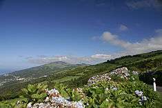 Interior range of the Volcanic Complex of Topo, dividing the northern and southern parishes of the municipality of Calheta | |||
|
|||
| Official name: Concelho de Calheta | |||
| Name origin: Portuguese for small harbour | |||
| Country | |||
|---|---|---|---|
| Autonomous Region | |||
| Island | São Jorge | ||
| Civil Parishes | Calheta, Norte Pequeno, Ribeira Seca, Santo Antão, Topo | ||
| Center | Calheta | ||
| - elevation | 22 m (72 ft) | ||
| - coordinates | 38°36′5″N 28°0′46″W / 38.60139°N 28.01278°WCoordinates: 38°36′5″N 28°0′46″W / 38.60139°N 28.01278°W | ||
| Highest point | Pico dos Frades | ||
| - elevation | 946 m (3,104 ft) | ||
| - coordinates | 38°35′2″N 27°53′28″W / 38.58389°N 27.89111°W | ||
| Lowest point | Sea level | ||
| - location | Atlantic Ocean | ||
| - elevation | 0 m (0 ft) | ||
| Area | 126.26 km2 (49 sq mi) | ||
| - water | .10 km2 (0 sq mi) | ||
| - urban | 4.06 km2 (2 sq mi) | ||
| Population | 3,773 (2011) | ||
| Density | 30/km2 (78/sq mi) | ||
| Settlement | c. 1483 | ||
| - Municipality | c. 1534 | ||
| LAU | Câmara Municipal | ||
| - location | Rua 25 de Abril | ||
| President | Duarte Manuel de Bettencourt da Silveira (PPD-PSD) | ||
| Timezone | Azores (UTC-1) | ||
| - summer (DST) | Azores (UTC0) | ||
| Postal Zone | 9850-032 | ||
| Area Code & Prefix | (+351) 292 XXX-XXXX | ||
| Demonym | Calhetense | ||
| Patron Saint | Santa Catarina de Alexandria | ||
| Municipal Holidays | 25 November | ||
 Location of the municipality of Calheta in the archipelago of the Azores
| |||
| Wikimedia Commons: Calheta (Azores) | |||
| Website: http://cm-calheta.azoresdigital.pt/ | |||

Calheta (Portuguese pronunciation: [kɐˈʎetɐ]) is a municipality on the island of São Jorge, in the Portuguese autonomous region of Azores. The municipality includes the eastern portion of the island of São Jorge and borders the municipality of Velas. The population in 2011 was 3,773,[1] in an area of 126.26 km².[2]
History
The first reference to São Jorge was in 1439, but it wasn't until 1470, when colonial nuclei dotted the southern and western coast: the first of these colonists were believed to have come from northern Europe. The municipality of Calheta, whose first settlers arrived around the 1480s (principally in the area of Topo, but later into the sheltered coves and fajãs) along the southern coast of the island). The island of São Jorge was ceded to João Vaz Corte-Real on May 4, 1483, becoming the first Captain-Donatario, thus initiating the primary settlement of the island. This phase of development is notable for the settlement of Willem van der Haegen, a Flemish pioneer of Azorean colonization who traveled and settled in Faial, Corvo and Terceira). His final resting place was in the settlement of Topo, which he founded with other Flemish settlers; he died in 1500, and was buried in the chapel-annex to the Solar dos Tiagos. Topo was later elevated to municipality and its village the municipal seat, on September 12, 1510.
Meanwhile, other settlements developed rapidly due to a number of sheltered anchorages and the fertility of the small fajãs where colonists established homes. Fajã de São João, one of this settlements along the southern coast, had settlers as early as 1550 (this is conjecture established from the Chapel of São João. In Topo, the community established a port in order to establish trade with Terceira (at that time the largest municipal and commercial center in the Azores). Other settlements radiated from the coastal beachheads and the growth of the number of colonists justified the de-annexation of the parish of Calheta from the municipality of Velas. Demonstrating an economic vitality (based on its vineyards, cereal crops, yams and the exploration of lichen roccella which was being exported to Flanders for use in the dye industry), it was elevated to the status of {{pt:Vila}} on June 3, 1534, by decree of King John III of Portugal.[3]
Other calamities have affected the early inhabitants: several dry seasons, numerous earthquakes and volcanic eruptions (1580–1757, 1808 and 1980), and on July 21, 1694 there occurred another tragic conflict that would later be known as the Motim dos Inhames ("The Taro Revolt"). It was a peasant uprising against an imposed tax or tithe on taro production. Taro was a staple of the peasant class, and tax on these tuberculoses generated a large revenue for the administrative government. After three years of leniency, in 1692, Francisco Lopes Beirão (the local sheriff) ordered his agents to pressure the locals to pay their "tax". This created tensions between the political and peasants classes, exploding into hostility in the community of Ribeira da Areia between citizens in the northern half of Calheta and tax-collectors from the village of Velas. Although this conflict was settled by the local vicar, Francisco Lopes Beirão petitioned the King, and he sent João de Soveral e Barbuda to São Jorge to determine and imprison the responsible parties. In the end many peasants, their supporters from the Council in Calheta and residents of Topo were interrogated, imprisoned and required to pay outstanding taxes. Many became penniless, died of famine, or were imprisoned in the Castle of São João Baptista, the prison in Angra do Heroísmo or the jail across the Canal in Horta. Future Calhetenses would use the leaves of the taro on their rifles in honour of the events.
The parochial Church of Santa Catarina was constructed following a fire that destroyed the original chapel (January 8, 1639), that dated back to the early 16th century. As a convent was ordered constructed, on May 12, 1718, the church was also remodeled.
The Calhetense settlers did not escape the attacks and destruction caused by pirates in the waters of the archipelago. English and French privateers, in addition to Turkish and Algerian (Barbary Coast) pirates in the Canal between Pico and São Jorge, persisted during the 16-17th Centuries. In 1597, a section of the squadron commanded by the Count of Essex, attacked the village of Calheta. To repel the invaders, the inhabitants, hurrelled rocks (their only defense) from the cliffs at the English privateers attempting to reach the shore. During the battle, one Portuguese soldier, Simão Gote was able to rob the ensign of their flag, and escape with it victoriously. In the 18th century, the French corsair René Duguay-Trouin pillaged the settlements in São Jorge, and in 1816 an Algerian pirate, while attempting to hunt and capture a merchant clipper was shelled by the cannons in the local fort in Calheta.
The sheltered cove was elaborated in 1755, and a lighthouse constructed in 1873 to improve navigation and shipping.
In addition to the parochial church, the Church of Santo António was completed in 1816, along the Rua de Baixo which connects Calheta and Ribeira Seca.
The village was destroyed by the July 9, 1757 earthquake, which became known as Mandado de Deus ("Sent by God"); the earthquake (which was located off the northern coast of Calheta) was responsible for the complete destruction of the homes in the municipality and the death of 1200 people on the island.
The local philharmonic band was one of the earliest organizations to develop, and dates back to 1868.
A water network was completed in the principal urbanized area around 1878, with the completion of the local fountain.
Geography
The five parishes of Calheta are:
- Calheta
- Norte Pequeno
- Ribeira Seca
- Santo Antão
- Topo - it was the first municipality established on the island of São Jorge (currently less than 500 inhabitants), pioneered by a group of Flemish settlers, captained by Willem van der Haegen.
Economy
Two tuna-processing factories exist in this municipalities: one in Fajã Grande and the other in proximity to the port of Calheta. Due to overfishing, activities in these factories have been suspended. Consequently, plans to convert the factory into a tourist hotel have progressed for the factory in Calheta. Similarly, the Port of Calheta used to be a center for the construction of trans-Atlantic ships, but has since been used for local fishing and trans-shipment services. As the central place in the southern eastern part of the island, the area includes various banks, commercial establishments, as well as the location of the Volunteer Fire Department and the home of the island's Santa Casa da Misericórdia (home and support for the elderly).
References
- ↑ Instituto Nacional de Estatística
- ↑ Eurostat Archived September 6, 2014, at the Wayback Machine.
- ↑ Arquivo dos Açores, Vol. V, pág. 141
| Corvo | ||
|---|---|---|
| Faial | ||
| Flores | ||
| Graciosa | ||
| Pico | ||
| Santa Maria | ||
| São Jorge | ||
| São Miguel | ||
| Terceira | ||