Canterbury-Bankstown
| Canterbury-Bankstown New South Wales | |
|---|---|
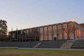 Bankstown Town Hall | |
| LGA(s) | Canterbury-Bankstown Council |
| State electorate(s) | |
| Federal Division(s) | |
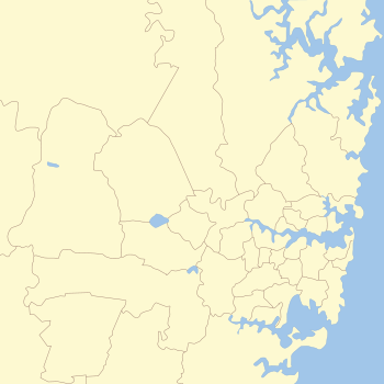
Canterbury-Bankstown is the area located around the Bankstown railway line. The suburbs of the Canterbury-Bankstown region are not specific to the local government areas of Canterbury-Bankstown Council although includes many of them. The Georges River acts as the southern boundary of this region.
History
The original inhabitants of Canterbury and Bankstown were the Gweagal, Bidjigal, (also known as Bediagal) and a small portion of the Dharug people.
Five years after the First Fleet arrived in Sydney Cove in 1788, a man by the name of Rev Richard Johnson, a chaplain aboard the First Fleet, was the first to receive a land grant of 40 hectares in what is now known as the 'Canterbury-Bankstown region'. The land was located in the Ashbury-Hurlstone Park area. He named his estate 'Canterbury Vale', presumably after the See of Canterbury in England. The date of the grant was May 1793 although he (Johnson) occupied the land months earlier. Johnson also cultivated land around his cottage in Bridge St Sydney and at another location called the Brickfield near Central Station. Johnson was praised by Watkin Tench as being one of the best farmers in the colony.[1]:4, 6, 81
The first ambulance to service the area was in 1908. It was called the 'Canterbury District Ambulance Corps' and it used volunteers to transport patients to the hospital. A stretcher on wheels with a hooded cover over it (hand litter) was used to transport patients to the Western Suburbs Hospital. If a patient lived in an area around Belmore, the hand litter was transported by train from Campsie to Belmore, then it was pushed along the rough unsealed roads to the patients home, back to Belmore station, then taken by train to Campsie Station and along the streets to hospital.
The Canterbury District Memorial Hospital commenced business on 26 October 1929. The hospital was opened by Secretary for Public Works Buttenshaw. Prior to the opening of the hospital [in Canterbury], residents attended the Western Suburbs Hospital or the cottage hospital located in Marrickville, which was established in 1895.
In 1940, the events of World War II were made known to the residents of Canterbury-Bankstown. Men and women who were drafted had to report for duty at a drill hall located on Canterbury Road Belmore. Camps were set up in Canterbury Race Course and surrounding parks in the region. In that same year thousands of Australian troops travelled along the goods line to Darling Harbour, ready to embark for the Middle East.
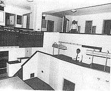
In 1940 the department of Civil Aviation purchased 250 hectares of land in Bankstown for the construction of Bankstown Airport and an RAAF Station was formed. The facility was a secondary airport to Mascot Airport. In 1942 a command bunker (Sydney Air Defence Headquarters) of semi underground construction was established on the corner of Edgar and Marion Street Bankstown. The bunker was manned by No. 1 Fighter Sector RAAF, members of the No.2 Volunteer Air Observer Corps, the WAAAF's, the RAAF and the United States Army Air Forces. The primary use of the Sydney Air Defence Headquarters was the location, tracking and interception of all planes in the eastern area of the South West Pacific.[2][1]:89
In 1941 WAAAF's were posted to Bankstown. The women were trained as clerks, wireless telegraphists, mess orderlies, drill instructors and drivers, a portion of these women were assigned to work in the command centre (Bankstown Bunker) located on Black Charlies Hill. In 1942, Belmore House, the current sight of today's Roselands Shopping Centre was used by the Australian Army for the training of troops. Tents on the property were used to house an infantry battalion and an ambulance corps. The site was vacated after a year. Units of the US Air Force were based in Bankstown after 1942, earning the suburb the nickname 'Yankstown'. Also in 1942 a military hospital was established for the U.S. Army at Herne Bay, now known as Riverwood. It was the largest military hospital in Australia during World War II. Known as the 118 General Hospital it consisted of 490 timber barracks-type buildings, which could house a total of 4,250 beds and accommodate up to 1,250 patients and 3,500 staff.[1]:94
Within the same year 16 US fighter planes that were based at Bankstown airport flew over Canterbury racecourse at low altitude during a race meet. This was to let the Australian public, especially those of the district to know that they, their allies were there for their protection. Regardless of these events, punters were annoyed at the disruption caused.
From 1944 to 1945 a Volunteer Air Observer Corps operated in Bankstown. These volunteers were both male and female, were of 15 to 60 years of age and were given several weeks training. There were over 300 volunteers who worked in shifts that the air force called 'flights' 24 hours a day, seven days a week. This freed RAAF personnel for other duties. In 1945 Bankstown Airport was occupied by the British Fleet Air Arm, known as HMS Nabberley, and the RAAF by 1946.[2][1]:88, 90, 91–94
Economy
Multinational companies such as Volkswagen and Cosentino have based Australian operations in the region. There is also major investment by local and foreign companies in the aviation, Print media and retail.
Region
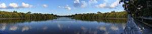
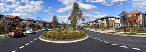
The Canterbury-Bankstown region is characterised by high-density housing towards the east and larger family homes towards the west with large natural parklands toward the south, such as those around Salt Pan Creek. Suburbs within the region have a multicultural nature.
Young families and couples are opting to live in the Canterbury-Bankstown region as a cheaper alternative to living in Sydney's Inner West, whilst at the same time residents of the region are suffering heavily from mortgage repossession which is forcing poorer families to move into Sydney's Outer Western Suburbs.
Suburbs
The Canterbury-Bankstown region is not an exact area, although the following suburbs are usually agreed to be a part of the region:
|
|
|
Commercial areas
The biggest commercial areas in the Canterbury-Bankstown area are located at Bankstown, Campsie and Roselands. Bankstown is the largest central business district in the region and features a large shopping centre called Bankstown Central. Roselands also features a large shopping centre called Roselands Shopping Centre. The Canterbury-Bankstown region also has a variety of Vietnamese, Lebanese, Greek, Italian, Spanish, African and Australian restaurants, delicatessens, sweet shops, grocery and fresh food markets.
Transport
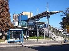
Canterbury, Liverpool and Punchbowl Roads are the main roads through the area. Public transport in the region includes trains and buses. Sydney Trains's Bankstown Line runs from the City Circle to Liverpool or Lidcombe via Campsie and Bankstown. The Airport Line also runs from the City Circle and has all stations services that terminate at Revesby and limited stops services which continue onto the Macarthur region's Macarthur and Campbelltown stations. This line also provides a direct connection from the region to Sydney Kingsford-Smith Airport. There are various bus routes provided largely by the privately owned companies Punchbowl Bus Company and Veolia.
Education
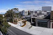
The Canterbury-Bankstown area houses the Bankstown Campus of the University of Western Sydney.
Population
Like Sydney's inner west, Canterbury-Bankstown is multi-cultural. There is a significant Chinese, Indian, Korean, Fijian, Vietnamese, Lebanese, Greek, Italian, Yugoslav and African population. This is also reflected in the variety and style of many local businesses and cultural institutions.
Notable former residents include the former Prime Minister John Howard[3] and Paul Keating [4] and Olympian Ian Thorpe.[5]

Organisations
- The Canterbury-Bankstown Rugby League Football Club
- Canterbury-Bankstown Express, local newspaper [6]
- Canterbury-Bankstown Migrant Resource Centre [7]
Politics
The federal divisions of Banks, Blaxland, Grayndler and Watson are located within part or all of the region of Canterbury-Bankstown. The state electoral districts of Bankstown, Canterbury, East Hills and Lakemba are located within part or all of the region. The region is covered the Canterbury-Bankstown Council, a local government authority.[8] It is a relatively safe region for the Labor party.
References
- 1 2 3 4 Lawrence, Joan; Madden, Brian; Muir, Lesley (1999). A Pictorial History of Canterbury Bankstown. Alexandria: Kingsclear Books. ISBN 978-0-908272-55-6.
- 1 2 Drucker, G. "Index of Fleet Air Arm Air Stations in the Commonwealth 1939-1945". Fleetairarmarchive.net. Retrieved 23 November 2013.
- ↑ Archived 31 March 2008 at the Wayback Machine.
- ↑ Archived 29 August 2007 at the Wayback Machine.
- ↑ "Sydney City Guide - Bankstown". Angelfire.com. 2007-01-12. Retrieved 2013-11-23.
- ↑ http://theexpress.com.au/
- ↑ http://www.cbmrc.org.au/links.php
- ↑ "Canterbury-Bankstown Council". Stronger Councils. Government of New South Wales. 12 May 2016. Retrieved 14 May 2016.