Clemton Park, New South Wales
| Clemton Park Sydney, New South Wales | |||||||||||||
|---|---|---|---|---|---|---|---|---|---|---|---|---|---|
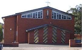 St Bernadette's Catholic Church, Bexley Road and William Street intersection | |||||||||||||
| Population | 1,565 (2011 census)[1] | ||||||||||||
| Postcode(s) | 2206 | ||||||||||||
| Location | 13 km (8 mi) south-west of Sydney CBD | ||||||||||||
| LGA(s) | Canterbury-Bankstown Council | ||||||||||||
| State electorate(s) | Lakemba | ||||||||||||
| Federal Division(s) | Barton | ||||||||||||
| |||||||||||||
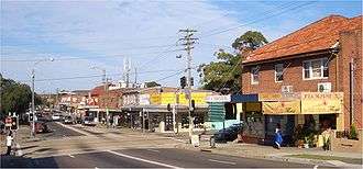
Clemton Park is a suburb in south-western Sydney, in the state of New South Wales, Australia. It is 13 kilometres south-west of the Sydney central business district in the Canterbury-Bankstown Council. A small group of shops is located at the intersection of Bexley Road and William Street.
A reserve called Clemton Park is located on Moorefields Road, it is the home ground of the Earlwood Wanderers Cricket Club 6th grade team of 2013 / 14. Clemton Park Public School, located on Bexley Road, is for years K-6.
History
This area was part of the 50-acre (200,000 m2) Laycock estate granted to Hannah Laycock (1758-1831), the wife of Quartermaster Thomas Laycock (1756-1809), in 1804.
Frederick Moore Clements, who became wealthy from selling the family health restorer, Clements Tonic, owned 40 acres (160,000 m2) near William Street until his death in 1920. 'Clementon Park' was an early suggestion for the suburb’s name but records show Clemton Park was used from 1925.[2]
Demographics
At the 2011 census, there were 1,565 residents in Clemton Park. In Clemton Park, 58.1% of people were born in Australia. The most common countries of birth were Greece 6.8%, China 4.7%, Portugal 3.7%, Lebanon 3.0% and Italy 2.2%. Family households (77.1%) were the main type of household, with 21.5% single person households and 1.5% group households.[1]
References
- 1 2 Australian Bureau of Statistics (31 October 2012). "Clemton Park (State Suburb)". 2011 Census QuickStats. Retrieved 30 April 2013.
- ↑ Pollon, Frances; Healy, Gerald (1988). The Book of Sydney Suburbs. Angus & Robertson. p. 63. ISBN 978-0-207-14495-0.
Coordinates: 33°55′48″S 151°06′22″E / 33.930°S 151.106°E
| Wikimedia Commons has media related to Clemton Park, New South Wales. |