Lansdowne, New South Wales
| Lansdowne Sydney, New South Wales | |||||||||||||
|---|---|---|---|---|---|---|---|---|---|---|---|---|---|
 | |||||||||||||
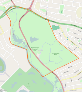 Boundaries of Lansdowne | |||||||||||||
| Postcode(s) | 2163 | ||||||||||||
| Location | 27 km (17 mi) west of Sydney CBD | ||||||||||||
| LGA(s) | Canterbury-Bankstown Council | ||||||||||||
| State electorate(s) | Bankstown | ||||||||||||
| Federal Division(s) | Blaxland | ||||||||||||
| |||||||||||||
Lansdowne is a suburb in south-western Sydney, in the state of New South Wales, Australia. Lansdowne is located 27 kilometres west of the Sydney central business district, in the local government areas of the Canterbury-Bankstown Council and is part of the South-western Sydney region.
History
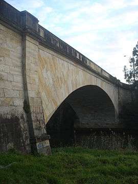
Lansdowne took its name from the Lansdowne Bridge, which was named by Governor Richard Bourke to honour Henry Petty-Fitzmaurice, 3rd Marquess of Lansdowne (1780-1863), a Whig politician.
The Lansdowne Bridge was built in 1834-35 from stone quarried on the banks of the Georges River. It replaced a hardwood bridge called Bowler’s Bridge because it led to Bowler’s Inn. The Lansdowne Bridge was one of the finest works by Scottish stonemason David Lennox (1788-1873), who arrived in Sydney in 1832 and was made Superintendent of Bridges with the task of replacing hardwood bridges that were frequently swept away in floods.
Many minor roads in the area bounded by the Hume Highway, Prospect Creek and Hazel Street have been resumed to form the Mirambeena Regional Park and Lansdowne Park, which boast pedestrian/cycle-paths, a number of man-made lakes, recreational reserves and a quality restaurant.
Note that this suburb's name has occasionally in the past appeared on maps with a spelling of 'Landsdowne'.[1]
Transport
Lansdowne Bridge is a sandstone bridge built by David Lennox that (from 1957) carries northbound-only traffic of the Hume Highway over Prospect Creek which opened in 1836. Henry Lawson Drive runs along the western border of Lansvale, through Mirambeena Regional Park.
The Meccano Set is a notable set of traffic lights at the intersection of the Hume Highway, Henry Lawson Drive and Woodville Road.[2][3]
Parks
- Lansdowne Park features a road cycling circuit.
- Mirambeena Regional Park sits beside Prospect Creek
References
- ↑ The Book of Sydney Suburbs, Compiled by Frances Pollen, Angus & Robertson Publishers, 1990, Published in Australia ISBN 0-207-14495-8
- ↑ Consultation on the future of the Meccano Set Roads & Maritime Services
- ↑ Meccano set future on hold Daily Telegraph 9 June 2015
Coordinates: 33°53′42″S 150°58′27″E / 33.89499°S 150.97418°E