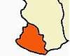
Kanyakumari
| Kanyakumari கன்னியாகுமரி കന്ന്യാകുമാരി | |
|---|---|
| Town | |
|
Kanyakumari | |
| Nickname(s): Cape Comorin | |
 Kanyakumari  Kanyakumari | |
| Coordinates: 8°04′41″N 77°32′28″E / 8.078°N 77.541°ECoordinates: 8°04′41″N 77°32′28″E / 8.078°N 77.541°E | |
| Country |
|
| State | Tamil Nadu |
| District | Kanyakumari |
| Government | |
| • District Collector | Sajjansingh R. Chavan |
| Area | |
| • Total | 25.89 km2 (10.00 sq mi) |
| Elevation | 30 m (100 ft) |
| Population (2012) | |
| • Total | 29,761 |
| • Density | 665/km2 (1,720/sq mi) |
| Languages | |
| • Official | Tamil |
| • Spoken languages | Tamil, Malayalam, English |
| Time zone | IST (UTC+5:30) |
| PIN | 629 702,629 001,629 165 |
| Telephone code | 91-4652 |
| Vehicle registration | TN 74 & TN 75 |
| Website |
www |

Kanyakumari ![]() pronunciation , also known as Kanniyakumari, formerly known as Cape Comorin, is a town in Kanyakumari District in the state of Tamil Nadu in India. The name comes from the Devi Kanya Kumari Temple in the region. It is the southernmost tip of peninsular India. Kanyakumari town is the southern tip of the Cardamom Hills, an extension of the Western Ghats range. The nearest town is Nagercoil, the administrative headquarters of Kanyakumari District, 22 km (14 mi) away. Kanyakumari has been a town since Sangam period[1][2] and is a popular tourist destination.[3]
pronunciation , also known as Kanniyakumari, formerly known as Cape Comorin, is a town in Kanyakumari District in the state of Tamil Nadu in India. The name comes from the Devi Kanya Kumari Temple in the region. It is the southernmost tip of peninsular India. Kanyakumari town is the southern tip of the Cardamom Hills, an extension of the Western Ghats range. The nearest town is Nagercoil, the administrative headquarters of Kanyakumari District, 22 km (14 mi) away. Kanyakumari has been a town since Sangam period[1][2] and is a popular tourist destination.[3]
History

Ptolemy's geography describes commercial relations between western India and Alexandria, the chief eastern emporium of the Roman Empire. He identified Kanyakumari along with the Gulf of Mannar as a center for pearl fishery. He also identifies Korkai (assumed to be the present day's Tuticorin), a place to the east of Kanyakumari, as an emporium of pearl trade.
Another ancient Greek book, the Periplus of the Erythraean Sea, contains sailing directions for merchants from the Red Sea to the Indus and Malabar, and even indicates that the coast from Barygaza (Baroch) had a general southward direction down to and far beyond Cape Komari.
Kanyakumari District consists of those parts known locally as Nanjil Nadu and Idai Nadu. The names of the villages of the district such as Azhagiapaandipuram, Bhoothapandy, Cholapuram and Kulasekaram reveal that these places were governed by several rulers at different periods of time. Nanjilnadu was under the rule of Pandiyas till the early 10th century and then under Cheras.
The Kalkulam and Vilavancode taluks were under the rule of the Chera Dynasty. When the power of Chola declined due to the rise of Hoysalas and western Chalukyas, the Venad (Travancore) Chieftains (descendants of the central Chera family) took advantage of the situation and gradually established their hold on considerable areas in Nanjilnadu. Veera Kerala Varma, one such chieftain, styled himself as "Nanjil Kuravan". The annexation commenced by Veera Kerala Varma was to a large extent continued by his successors and completed by AD 1115.
For about four centuries, the Venad was ruled by powerful kings who were consistently making incursions into the Pandian territories. As a result, Vijayanagar kings proceeded against Venad. In 1609 Kanyakumari fell into the hands of Viswanatha Nayak of Madurai. Consequent on this, there was no serious threat to Nanjilnadu until 1634. During the regime of Ravi Varma and Marthanda Varma, Venad was disturbed by the internal strife.
Sanda Sahib of Arcot took advantage of this situation and attacked Nanjilnadu. Although Marthanda Varma was victorious in the battle of Colachel and defeated the Dutch armouries who helped the local feudatories, he could not cope with the threat from Sanda Sahib, which forced him to withdraw from the battlefield. After Marthanda Varma, Venad had weak rulers and as a result there was frequent interference by the British (who knew it as Cape Comorin) whose control was completely established over Venad and continued until 1947. From 1947 to 1956, it was under the personal rule of Maharaja of Travancore. During the period between 1956–1961, the administrative system has fallen in line with that of other districts in Tamil Nadu.[4]
Modern history

Kanyakumari has been a great centre for art and religion for centuries. It was also an area of great trade and commerce. It was ruled by the Cholas, the Cheras, the Pandyas and the Nayaks. The architectural beauty of the temples in the area are the works of these rulers. Later Kanyakumari became part of the Venad kingdom with its capital at Quilon. The king of Venad, Anizham Thirunal Marthanda Varma, established Travancore by extending his domain further north up to Azhva, during his reign from 1729 to 1758. By this, the present Kanyakumari District came to be known as Southern Travancore. In 1741, Maharaja Marthanda Varma defeated the Dutch East India Company at the famous Battle of Colachel.
Kanyakumari was under the rule of the Pandyan Kings till the downfall of Pandyas, and later by kings of Travancore under the overall suzerainty of the British (as "Cape Comorin") until 1947, when India became independent. Travancore joined the independent Indian Union in 1947. The reign of the Travancore royals came to an end.
In 1949, Kanyakumari became part of the reconstituted Travancore-Cochin State. Around this time, a popular agitation by the Tamil-speaking people of the district for the amalgamation of Kanyakumari District with Tamil Nadu intensified under the leadership of Marshal Nesamony who is called as 'Kumari Thanthai' (Father of Kanyakumari district). Marshal Nesamony was instrumental in the merger of Kanyakumari district with Tamil Nadu (then known as Madras State) in 1956 during the linguistic reorganisation of states.
Demographics
As of the census of India 2001, Kanniyakumari had a population of 19,739 comprising 9,884 males and 9,855 females, making the sex ratio (number of females per thousand males) of the town to 997. A total of 2,403 people were under six years of age and the child sex ratio (number of females per thousand males under six years of age) stood at 1,024. The town had an average literacy of 88.62%, higher than the national average of 59.5%.There were total of 4,236 households in the town. As of 2001, Kanniyakumari had a total of 5,929 main workers: 11 cultivators, 78 agricultural labourers, 66 in house hold industries and 5,774 other workers. There were a total of 119 marginal workers: 4 marginal cultivators, 3 marginal agricultural labourers, 11 marginal workers in household industries and 101 other marginal workers.[5]
Geography
Kanyakumari is located at 8°05′N 77°34′E / 8.08°N 77.57°E.[6] It has an average elevation of 300 metre. Contrary to the popular (and sensational) belief that Kanyakumari lies at the meeting point of three bodies of water, it borders only one: the Laccadive Sea to the south west, south, and to the southeast. It is the confluence of the Western Coastal Plains and Eastern Coastal Plains.
It is located at the southern tip and southernmost point of the Indian Subcontinent. However, the southernmost point of the Republic of India is at Indira Point on Great Nicobar Island, at 6°45’10″N and 93°49’36″E.
Kanyakumari is used geographically to define southern end of the Coromandel Coast region.
| Climate data for Kanyakumari | |||||||||||||
|---|---|---|---|---|---|---|---|---|---|---|---|---|---|
| Month | Jan | Feb | Mar | Apr | May | Jun | Jul | Aug | Sep | Oct | Nov | Dec | Year |
| Average high °C (°F) | 28.9 (84) |
30.6 (87.1) |
32.2 (90) |
32.7 (90.9) |
32.4 (90.3) |
30.7 (87.3) |
31.8 (89.2) |
31.9 (89.4) |
30.6 (87.1) |
30.4 (86.7) |
30.1 (86.2) |
29.3 (84.7) |
30.97 (87.74) |
| Average low °C (°F) | 23.4 (74.1) |
23.8 (74.8) |
25.1 (77.2) |
26.1 (79) |
26.1 (79) |
24.6 (76.3) |
24 (75) |
24 (75) |
24.3 (75.7) |
24.3 (75.7) |
24 (75) |
23.8 (74.8) |
24.46 (75.97) |
| Average rainfall mm (inches) | 10 (0.39) |
23 (0.91) |
36 (1.42) |
81 (3.19) |
56 (2.2) |
86 (3.39) |
44 (1.73) |
42 (1.65) |
37 (1.46) |
166 (6.54) |
203 (7.99) |
75 (2.95) |
859 (33.82) |
| Average precipitation days | 1.4 | 1.7 | 2.6 | 4.1 | 4.2 | 11.3 | 9 | 6.5 | 5.5 | 10.1 | 11.2 | 5.3 | 72.9 |
| Source: World Weather Information Service,[7] | |||||||||||||
Tourism
This area is very beautiful. Since the early 1970s, tourism has been an industry in the town. Because of this it is one of the few small towns in South India where one can hear many of the different languages of India spoken in the street.
Of late, the promotion of tourism has increased, with increasing emphasis on attractions outside the town, such as the surrounding landscapes, as well as the historical and religious sites found around the district. Ultimately a total of 1.9 million tourists (domestic and foreign) visited Kanyakumari in 2007.[9]
Though there are several places of tourist-interest in the town and district, Kanyakumari is especially popular in India for its spectacular and unique sunrise and sunset, thanks to its being nearly surrounded by waters. On balmy, full-moon evenings (locally called Chitra Pournami), one can also see the moon-rise and sunset at the same time.
Pilgrimage
Kanya Kumari is notable for pilgrimage and tourism. The place takes its name from the goddess Devi Kanya Kumari, considered to be a sister of Krishna. Women pray to her for marriage. The goddess is believed to be the one who removes the rigidity of our mind. The temple here is a Shakti Peetha, one of the holiest shrines of the Mother goddess. Also nearby are eleven sacred theertham.[10]
The place was called Kanyashram of the Baalaambika, the deity of the temple. The sea ablution for Pitr Tarpan is done here. This is one of the rare temples in India where Devi (Mother Goddess) is worshipped as a child. The rites and rituals are done in the Kerala Namboothiri method, so there are slight differences in the way of worship compared to the temples of the nearby region. The deity is the goddess of Sanasa,[10] so people from all over India who desire to devote their life as Sanyasin come here and take the deeksha. Swami Vivekananda came to this temple as directed by his Guru Shri Ramakrishna Prarama Hamsa, being a Sanyasin. The temple is very old and is mentioned in ancient Sanskrit literature.
The beach sands are multi-coloured and likened to a mythological story.
There is a shrine for Kalabhairava in the temple. It is said that the backbone area of Sati Devi’s corpse fell here.
The place is famous for Agastyar mala where Sage Agastya lived. He is the founder of Siddha vydya, so there is innumerable medicinal plants available here. He is also considered as the founder of Varma Kalai, a form of martial arts.
Another pilgrimage is Nagaraja Temple, Nagercoil nearby.
At the Thanumalayan Temple in Suchindram, the three main gods of Hindu mythology – Śiva, Brahmā and Viṣṇu – are in one form called Sthanumalayan.
Transportation
Road
- Bus: Kanyakumari, Nagercovil, Midalakadu & Marthandam
Rail
Important Railway stations : CAPE/Kanniyakumari, Nagercoil, Eraniel & Kuzhithurai.
Important Trains :
- 12641/Thirukkural Express
- 12665/Howrah - Kanyakumari Weekly SF Express
- 22621/Rameswaram - Kanyakumari SF Express
- 12633/Chennai Egmore - Kanniya Kumari SF Express
Places of interest
[11] There are many places to visit in Kanyakumari, following list does not comprise all but are some of the notable places.
Thiruvalluvar Statue

The Thiruvalluvar Statue has a height of 95 feet (29 m) and stands upon a 38 foot (11.5 m) rock that represents the 38 chapters of "virtue" in the Thirukkural. The statue standing on the rock represents "wealth" and "pleasures", signifying that wealth and love be earned and enjoyed on the foundation of solid virtue.[12] The combined height of the statue and pedestal is 133 feet (40.5 m), denoting the 133 chapters in the Thirukkural. It has a total weight of 7000 tons.The statue, with its slight bend around the waist is reminiscent of a dancing pose of the ancient Indian deities like Nataraja. It was sculpted by the Indian sculptor Dr. V. Ganapati Sthapati, who also created the Iraivan Temple. Its opening ceremony was on 1 January 2000. The monument was hit by the Indian Ocean Tsunami on 26 December 2004.[13]
Vivekananda Rock Memorial

The Vivekananda Rock Memorial is a popular tourist monument in Vavathurai, Kanyakumari, India. The memorial stands on one of two rocks located about 500 metres east of the mainland of Vavathurai, India's southernmost tip. It was built in 1970 in honour of Swami Vivekananda who is said to have attained enlightenment on the rock.[1] According to local legends, it was on this rock that Goddess Kumari performed austerity. A meditation hall (Dhyana Mandapam) is also attached to the memorial for visitors to meditate. The design of the mandapa incorporates different styles of temple architecture from all over India. It houses a statue of Vivekananda. The rocks are surrounded by the Laccadive Sea. The memorial consists of two main structures, the Vivekananda Mandapam and the Shripada Mandapam.[3]
Gandhi Memorial Mandapam

The Gandhi Memorial Mandapam has been built on the spot where the urn containing the Mahatma's ashes was kept for public viewing before immersion. Resembling central Indian Hindu temples in form, the memorial was designed in such a way that on Mahatma Gandhi's birthday, 2 October, the first rays of the sun fall on the exact place where his ashes were kept.[3]
Tsunami Memorial Park

Near Kanyakumari's southern shore stands a monument to the memory of those who died in the 2004 Indian Ocean earthquake and tsunami, an underwater megathrust earthquake that claimed around 280 000 lives in many countries, including India, Sri Lanka, Somalia, Thailand, Maldives and Indonesia. People from places near and far visit this monument to pay homage to all those who lost their lives.
Bhagavathy Amman Temple

Bhagavathy Amman Temple is a 3000-year-old temple dedicated to Goddess Kumari Amman located at Kanyakumari. Kumari Amman is one of the form of Devi, popularly known as “Kumari Bhagavathy Amman”. Kumari Bhagavathy Amman temple is the first Durga temple created by Lord Parasurama and one of the 108 Shakthi Peethas. This temple is situated at the shore of the Laccadive Sea. Kumari temple has been mentioned in Ramayana, Mahabarata and Purananooru.[14]
Ayya Vaikundar Nizhal Thangal
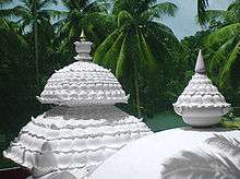
Ayya Vaikundar Nizhal Thangal is a beautiful shrine dedicated to Ayya Vaikundar in Attoor, a small hamlet in Kanyakumari. It is revered shrine for followers of Ayyavazhi, who believe that Ayya Vaikundar is an avatar or incarnation of Lord Narayana. Ayyavazhi, a dharmic belief system, is based on the teachings and life history of Ayya Vaikundar.The highlight of this place is its unique architectural style - Sahasrara (literal meaning white lotus). Historians believe that it is the first temple to boast Sahasrara architecture. Originally, this structure was built in 1988; however, it was reconstructed and inaugurated in the year 2007. The foundation stone of the new thangal was laid in 2005 by the present religious leader of Ayyavazhi - Bala Prajapathi Adikalar.
Kamarajar Mani Mantapa Monument
Kamarajar Mani Mantapa Monument was raised and dedicated to a freedom fighter and Former Chief minister of Tamil Nadu, President of Indian National Congress, Mr Kamarajar. He's also popularly known as Black Gandhi among the masses. Like the Gandhi Mantapa, this place is where Kamarajar's ashes were kept for the public to pay homage before immersion into the sea.[15]
Padmanabhapuram Palace
This granite palace is a fortress and was the residence of the Travancore rulers. It was constructed around 1601 AD. This palace also has a small museum that contains various artifacts from the older times.[16]
Gallery
 Kanyakumari Muttom beach
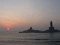 Sunrise with Thiruvalluvar Statue and Vivekananda rock in the foreground
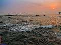 Sunset at Kanyakumari
 Light House, Kanyakumari
 Kanyakumari headland
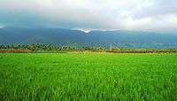 Nagercoil with its Scenic Beauty
 St. Xavier's Church
.jpg) Bhoothapandi Village
Bhoothapandi Village

 Thirparappu Falls.
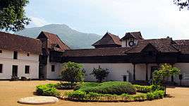
.jpg)
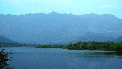 The Western Ghats at Pechiparai, Kanyakumari District, near the southern end of the range.
Tourist information

The state-owned Poompuhar Shipping Corporation runs ferry services between the town and the Vivekananda Rock Memorial and Thiruvalluvar statue, situated on rocky islets off the coast. The operation of the ferry service began in 1984. Two ferries were used to ferry the tourists until June 2013, after which a new ferry was added to the service on the occasion of 150th birth anniversary of Swamy Vivekananda.[17] Kanyakumari is directly connected by rail with almost all metropolitan cities in India.[18] The nearest airport is Thiruvananthapuram International Airport, 90 km (56 mi) from Kanyakumari Town and 70 km (43 mi) from Nagercoil.[19] Kanyakumari is 744 km (462 mi) from Chennai.[20]
The Tamil Nadu State Transport Corporation runs a circular bus to visit tourist spots. Circular bus route - Kanyakumari to Kanyakumari via Vattakottai, Padmanabhapuram palace, Thottipalam, Pechipparai dam, Thirparappu Falls, Muttom beach and Suchindrum Sthanumalayan temple. The bus will start at 7 a.m. just after sunrise and return to Kanyakumari by 6 p.m. so that tourists can also view sunset on sea. The fare per trip is Rs. 200/- for adults and Rs. 100/- for children.[21]
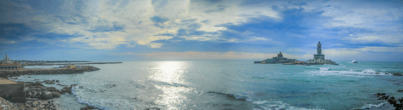
Panoramic View
Panoramic full view of kanyakumari sea, Thiruvalluvar Statue, Vivekananda Rock.
Religious significance
According to Hindu legend, Kanya Devi, an avatar of Parvati, was to marry Siva, but as he failed to show up on his wedding day, the rice and other grains meant for the wedding feast remained uncooked and remain unused thereafter. As the legend goes, the uncooked grains turned into stones as time went by. Some believe that the small stones on the shore today, which look like rice, are indeed grains from the wedding that was never solemnised. Kanya Devi is now considered a virgin goddess who blesses pilgrims and tourists who flock the town. According to another Hindu legend, Lord Hanuman dropped a piece of earth as he was carrying a mountain with his life-saving herb, Mrita Sanjivani, from the Himalayas to Lanka (Sri Lanka) during the Rama-Ravana war. This chunk of earth is called Marunthuvazh Malai, literally "hills where medicine lives". This is said to be the reason for the abundance of unique native medicinal plants in the area. Marunthuvazh Malai is located near Kottaram about 7 km (4 mi) from Kanyakumari town on the Kanyakumari-Nagercoil highway. The sage Agasthya, who was himself an expert in medicinal herbs, is believed to have lived around this site in ancient days. Some believe this is why so many medicinal herbs are to be found on these hills near Kanyakumari. A nearby village is named Agastheeswaram after the sage. Today, there is a small ashram on the middle of the Maruthuvazh Malai hill, which tourists visit (after a short trek from the base of the hill), both to visit the Ashram and also to take a glimpse of the sea near Kanyakumari a few kilometres away, and the greenery below.
See also
References
- ↑ Kanakasabhai, V (1997). The Tamils Eighteen Hundred Years Ago. Asian Educational Services. p. 10. ISBN 8120601505.
- ↑ Abraham, Shinu (2003). "Chera, Chola, Pandya: using archaeological evidence to identify the Tamil kingdoms of early historic South India.". Asian Perspectives. 42.
- 1 2 3 Gopal, Madan (1990). K.S. Gautam, ed. India through the ages. Publication Division, Ministry of Information and Broadcasting, Government of India. p. 179.
- ↑ "Ancient History of Kanyakumari". Retrieved 26 April 2012.
- ↑ "Primary census abstract 2001". Directorate of Census Operations – Tamil Nadu. 2001. Retrieved 29 December 2012.
- ↑ Falling Rain Genomics, Inc – Kanniyakumari
- ↑ "Climatological Information for Kanyakumari". World Weather Information Service.
- ↑ http://en.climate-data.org/location/34132/
- ↑ "Airport for Kanyakumari on the cards". The Hindu. 15 January 2008. Retrieved 17 September 2013.
- 1 2 "Kanyakumari Temples of Tamilnadu". templenet. 2013. Retrieved 25 July 2013.
- ↑ http://ecourts.gov.in/kanyakumari/our-district
- ↑ http://ecourts.gov.in/tn/kanyakumari
- ↑ "DETAILS ABOUT THE STATUE OF THIRUVALLUVAR". National Informatics Centre. Retrieved 18 February 2016.
- ↑ "History of Kumari Amman Temple".
- ↑ "Places to Visit in Kanyakumari". TripAdvisor. Retrieved 18 February 2016.
- ↑ "Top 5 Places To Visit In Kanyakumari". Trans India Travels. Retrieved 18 February 2016.
- ↑ "Third ferry service launched in Kanyakumari". The Hindu. 21 June 2013. Retrieved 27 September 2013.
- ↑ "Kanyakumari railway station needs better infrastructure". The Hindu. 18 February 2013. Retrieved 27 September 2013.
- ↑ "Kanyakumari". Retrieved 22 February 2012.
- ↑ "Kanyakumari District". Retrieved 22 February 2012.
- ↑ Kanyakumari Tourism, Kanyakumari beach.
External links
| Wikimedia Commons has media related to Kanyakumari. |
- Kanyakumari District Government Portal
-
 Kanyakumari travel guide from Wikivoyage