Washington meridians
The Washington meridians are four meridians that were used as prime meridians in the United States and pass through Washington, D.C.. The four which have been specified are:
- through the Capitol
- through the White House
- through the old Naval Observatory
- through the new Naval Observatory.
Their longitudes may be reported in three ways:
- relative to the local vertical used by astronomic observations
- relative to NAD 27 (North American Datum 1927), an ellipsoid of revolution that is at mean sea level beneath triangulation station Meades Ranch, Kansas (not Earth-centered);
- relative to NAD 83, an Earth-centered ellipsoid of revolution with dimensions chosen to best fit the undulating (±100 m) geoid (world-wide mean sea level).
NAD83 longitude of the Capitol is about 1.1 arc seconds less than its NAD27 longitude; astronomic longitude there is about 4 arc seconds less than NAD83.
Capitol meridian
Pierre (Peter) Charles L'Enfant specified the first meridian in his 1791 "Plan of the city intended for the permanent seat of the government of the United States . . ." (see: L'Enfant Plan).[1][2][3] (Shortly after L'Enfant prepared this plan, its subject received the name "City of Washington".) His plan stated near its right side that the longitude of the Congress house, now called the Capitol, was 0,0°.[2]
L'Enfant's plan contained the following explanatory note:
In order to execute the above plan, Mr. Ellicott drew a true meridian line by celestial observation, which passes through the area intended for the Congress-House; this line he crossed by another line due east and west and which passes through the same area. These lines were accurately measured, and made the basis on which the whole plan was executed. He ran all the lines by a transit instrument, and determined the acute angles by actual measurement, and left nothing to the uncertainty of the compass.[2]
The longitude of the center of the Capitol's dome (completed in 1863 during the Civil War) is now given by the National Geodetic Survey as 77°00'32.6"W (NAD 83).
White House meridian


L'Enfant planned Washington around a right triangle, having its 90° vertex at an equestrian statue of George Washington, its eastern vertex at the "Congress house" and its northern vertex at the "President's house", now named the "White House".[4] (This would place L'Enfant's statue 0.36 meters (1 ft 2 in) north of the latitude of the Capitol.)
The west side of L'Enfant's triangle forms a natural prime meridian passing through the President's house. The following nine features on and near this "Washington Meridian" are listed from south to north:
- The center of the Jefferson Memorial, completed on the meridian in 1943.[5]
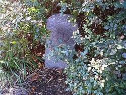
- In 1793 Secretary of State Thomas Jefferson surveyed and marked with a wooden post the southwest vertex of L'Enfant's triangle, establishing the second Washington meridian, the one through the President's house. The wooden post was replaced by the Jefferson Pier in 1804, while Jefferson was President of the United States. After removal and replacement several times, it was permanently replaced in 1889 by a 2-foot-square (0.6 m), 2-foot-tall, granite pier, now 390 feet (119 m) WNW of the center of the Washington Monument.[6] NGS gives its longitude as 77°02'11.56258"W (NAD 83) as of 2002 (likely error less than a centimeter). Azimuth to the Capitol is 89.98 degrees, a discrepancy of just under a meter.
- In 1890 the Meridian Stone was set at the center of the Ellipse, intended to be on the same meridian.[7] It is an 18-inch-square (46 cm) granite post set flush with the ground. NGS gives its longitude as 77°02'11.55880"W (NAD 83) as of 2002 (likely error less than a centimeter).
- In 1923, the Zero Milestone was set on the north side of the Ellipse, intended to be on the same meridian and to be the zero mileage point for all United States roads (but never was).[8] It is a granite pillar about 18 inches (46 cm) square and about 3.5 feet (1.1 m) tall. NGS gives its longitude as 77°02'11.57375"W (NAD 83) as of 2002 (likely error less than two centimeters).
- The center of the White House.[9]
- Clark Mills' equestrian statue of President Andrew Jackson in Lafayette Park, erected on the meridian in 1853 (see: Andrew Jackson (Mills)).[10]
- 16th Street Northwest, which extends due north from the White House.[11] The meridian is sometimes identified as the "16th Street Meridian" because of the location of this street.
- The following feature on this meridian no longer exists. It was a small freestone obelisk placed in 1804 on top of a hill 1.5 miles (2.4 km) north of the President's House, hence the name Meridian Hill. It was at the northern end of 16th Street, just north of Florida Avenue, before 16th Street was extended northward about 1890,[12] covering it up. Now adjoining the east side of 16th Street where the obelisk once stood is Meridian Hill Park.
- District of Columbia entrance marker stone (approximately 66 feet (20 m) east of this meridian) near Silver Spring in traffic circle (Blair Circle) at intersection of 16th Street Northwest, Eastern Avenue Northwest, N. Portal Drive Northwest and Colesville Road.[13]
Old Naval Observatory meridian
.jpg)
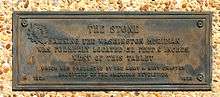
The third meridian was defined on September 28, 1850 by Congress: "[T]he meridian of the observatory at Washington shall be adopted and used as the American meridian for all astronomical purposes and ... the meridian of Greenwich shall be adopted for all nautical purposes."[15] The observatory decided that this meridian passed through the center of the original (small) dome atop the main building of the Old Naval Observatory, now abandoned southwest of the corner of E and 23rd Streets in Foggy Bottom (north of the Lincoln Memorial and west of the White House). The observatory adopted 77°2'48.0"W for its meridian in the American Ephemeris and Nautical Almanac for the years 1855 to 1869 (as 5h8m11.2s). In 1897, well after the observatory closed in 1892, the Coast and Geodetic Survey reported that its meridian was 77°3'2.3" west of Greenwich,[16] which was quoted for the next 50 years in the list of observatories in the Almanac (as 5h8m12.15s). When referred to later datums, this meridian has been variously specified as 77°3'6.119"W or 77°3'6.276"W (both presumably NAD 27). If NAD27, the latter would be 77°3'5.194"W (NAD 83) which seems to be within a few meters of the actual longitude, at worst. This meridian was repealed by Congress on August 22, 1912 to allow the Greenwich meridian to become the legal prime meridian of the United States.
Western state borders
Many western states have borders that are meridians of "longitude west of Washington", that is, west of the legal 1850 meridian through the Old Naval Observatory. However, their present boundaries follow the subsequently surveyed boundary, even when inaccurately marked a few miles (kilometers) east or west of the meridian in the statute. Other western states have meridians relative to Greenwich (Alaska, California, Oklahoma, Texas) or relative to a river or lake (Arkansas, Louisiana, Minnesota, Missouri, Oregon, Washington state).
The following meridians west of Washington are listed east to west, along with the appropriate boundary of the present state. The date of the meridian's definition is in parentheses (all in the 1860s). All states were territories of the same name when their meridians were specified except as noted. States without dates have boundaries dependent on the neighboring state with a date listed immediately above it.
| Degree | Boundary |
|---|---|
| 25° | W Kansas (January 29, 1861) as a state |
| E Colorado (February 28, 1861), NE not dependent on Kansas | |
| SW Nebraska | |
| 27° | E Montana (March 3, 1863) as Idaho Territory |
| E Wyoming (March 3, 1863) as Idaho Territory | |
| NW Nebraska | |
| W North Dakota as Dakota Territory | |
| W South Dakota as Dakota Territory | |
| 32° | W Colorado (February 28, 1861) |
| SE Utah | |
| E Arizona (February 24, 1863) | |
| W New Mexico | |
| 34° | SW Montana (May 26, 1864) |
| W Wyoming (July 25, 1868), SW not dependent on Montana | |
| SE Idaho | |
| NE Utah | |
| 37° | E Nevada (May 5, 1866) as a state (39° → 38° → 37°) |
| W Utah | |
| 39° | NW Montana (May 26, 1864) |
| NE Idaho |
New Naval Observatory meridian
The fourth meridian was through the clock room of the new Naval Observatory, 2.3 miles (3.8 km) northwest of the White House, at 77°3'56.7"W (1897) or 77°4'2.24"W (NAD 27) or 77°4'1.16"W (NAD 83). The clock room is a small building at the exact center of the 1000-foot (305 m) radius observatory grounds, whose northern entrance is at 34th Street and Massachusetts Avenue. It was used in the Almanac for the years 1898–1950 as the independent variable of time for a few tables (even though Washington's civil time since 1883 had been that of the standard time zone GMT−5 hours (75°W)).
See also
Notes
- ↑ (1) Pierre Charles L'Enfant's 1791 "Plan of the city intended for the permanent seat of the government ...." in official website of the U.S. Library of Congress. Retrieved 2008-08-13.
- 1 2 3 L'Enfant, Peter Charles (1791). "Plan of the city intended for the permanent seat of the government of t(he) United States : projected agreeable to the direction of the President of the United States, in pursuance of an act of Congress passed the sixteenth day of July, MDCCXC, "establishing the permanent seat on the bank of the Potowmac": (Washington, D.C.)". Photocopy of annotated facsimile created by U.S. Coast and Geodetic Survey, Washington, D.C. (1887). Library of Congress. Retrieved 2016-01-26.
- ↑ (1) Freedom Plaza in Northwest Washington contains an inlay of L'Enfant's Plan with a legend identifying the longitude of the Congress house as 0,0°.
(2) L'Enfant identified himself as "Peter Charles L'Enfant" during most of his life, while residing in the United States. He wrote this name on his "Plan of the city intended for the permanent seat of the government of t(he) United States ...." (Washington, D.C.) and on other legal documents. However, during the early 1900s, a French ambassador to the U.S., Jean Jules Jusserand, poipularized the use of L'Enfant's birth name, "Pierre Charles L'Enfant". (See: Bowling, Kenneth R (2002). Peter Charles L'Enfant: vision, honor, and male friendship in the early American Republic. George Washington University, Washington, D.C.) The National Park Service identifies L'Enfant as "Major Peter Charles L'Enfant" and as "Major Pierre (Peter) Charles L'Enfant" on its website. The United States Code states in 40 U.S.C. § 3309: "(a) In General.—The purposes of this chapter shall be carried out in the District of Columbia as nearly as may be practicable in harmony with the plan of Peter Charles L'Enfant." - ↑ "Map 1: The L'Enfant Plan for Washington". National Park Service. Archived from the original on January 21, 2009. Retrieved 2009-10-27.
- ↑ Coordinates of center of Jefferson Memorial: 38°52′53″N 77°02′12″W / 38.881379°N 77.036546°W
- ↑ Coordinates of Jefferson Pier: 38°53′23″N 77°02′12″W / 38.889812°N 77.036558°W
- ↑ Coordinates of Meridian Stone: 38°53′38″N 77°02′12″W / 38.893943°N 77.036548°W
- ↑ Coordinates of Zero Milestone: 38°53′42″N 77°02′12″W / 38.895117°N 77.036561°W
- ↑ Coordinates of center of the White House: 38°53′52″N 77°02′11″W / 38.897687°N 77.036495°W
- ↑ Coordinates of equestrian statue of Andrew Jackson in Lafayette Park: 38°53′58″N 77°02′12″W / 38.899523°N 77.036553°W
- ↑ Coordinates of south end of 16th Street NW: 38°54′01″N 77°02′12″W / 38.900293°N 77.036543°W
- ↑ Sixteenth Street, HABS DC-717, p. 5.
- ↑ Coordinates of District of Columbia entrance marker stone near Silver Spring in traffic circle at intersection of 16th Street Northwest, Eastern Avenue Northwest, N. Portal Drive Northwest and Colesville Road: 38°59′32″N 77°02′11″W / 38.992322°N 77.036326°W
- ↑ Coordinates of "The American Meridian" line in sidewalk of H Street NW at 24th Street NW, in southeast corner of intersection: 38°53′58″N 77°03′05″W / 38.8995°N 77.051315°W
- ↑ 9 Statutes at Large 515
- ↑ 3618 Serial Set 254
- ↑ Coordinates of Four Corners Monument: 36°59′56″N 109°02′43″W / 36.998976°N 109.045172°W, 1,807 feet (551 m) east of 32°W at 31.9938°W.
References
- Bedini, Silvio A. (1999). The Jefferson Stone: Demarcation of the First Meridian of the United States. Frederick, MD: Professional Surveyors Publishing Co.
- Toscano, Patrick (January 2000). "Book Review: Bedini, Silvio A. (1999), The Jefferson stone: Demarcation of the First Meridian of the United States". Professional Surveyor. Frederick, MD. 20 (1). Retrieved 2010-07-16.
- Waff, Craig B. (May 2001). "A Prime Meridian for the United States? Essay Review of Bedini, Silvio A. (1999), The Jefferson stone: Demarcation of the First Meridian of the United States" (PDF). Journal for the History of Astronomy. Cambridge, England: Sage journals]. 32, Part 2 (106): 157–159. Bibcode:2001JHA....32..157W. ISSN 0021-8286. Note: Contains much information from book.
- Pratt, Joseph Hyde (1942). "American Prime Meridians". Geographical Review. 32: 233–244. doi:10.2307/210272.
- Van Zandt, Franklin K. Boundaries of the United States and the several states, Geological Survey Professional Paper 909 (1976)
- American ephemeris and nautical almanac (Washington, DC: annual), preface and observatories
External links
- The 1791 L'Enfant plan and the Mall
- Map of L'Enfant's Plan
- Washington Monument GPS Project including Jefferson Pier and Zero Milestone (1.29 MB)
- Old Naval Observatory Old dome at center, 23rd Street at right.
- Washington Refractor describing the condition of Old Naval Observatory in 1972.
- Washington Monument GPS Height Modernization Project listing coordinates of Jefferson Pier, Meridian Stone, and Zero Milestone (click on names for photos)