Kurnell, New South Wales
| Kurnell Sydney, New South Wales | |||||||||||||
|---|---|---|---|---|---|---|---|---|---|---|---|---|---|
 Artwork depicting the first contact with Captain James Cook and crew with the Gweagal Aborigines | |||||||||||||
| Population | 2,213 (2011 census)[1] | ||||||||||||
| Postcode(s) | 2231 | ||||||||||||
| Location | 22 km (14 mi) S of Sydney CBD | ||||||||||||
| LGA(s) | Sutherland Shire | ||||||||||||
| State electorate(s) | Cronulla | ||||||||||||
| Federal Division(s) | Cook | ||||||||||||
| |||||||||||||
Kurnell is a suburb in Sydney, in the state of New South Wales, Australia. It is 21.4 kilometres (13.3 mi) south of the Sydney central business district, in the local government area of the Sutherland Shire along the east coast.
Kurnell is on the south eastern headland of Botany Bay. Cronulla and Woolooware are the only adjacent suburbs. La Perouse is located opposite, on the northern headland of Botany Bay.
The eastern side of the peninsula is part of Botany Bay National Park. Towra Point Nature Reserve is located on the western side of the suburb.
History
Kurnell is the place where Captain James Cook landed on 29 April 1770, making first contact with the original inhabitants of the area, the Gweagal Aborigines whilst navigating his way up the East Coast of Australia on Endeavour.[2] Captain Cook along with his crew stayed at Kurnell for a period of eight days. During their visit they collected botanical specimens, mapped the area and tried to make contact (unsuccessfully) with the indigenous population. When Cook reported back to England he said that the land was suitable for agriculture and was lightly wooded.[3]
Captain Arthur Phillip, arriving in H.M. Armed Tender Supply on 18 January 1788, before the First Fleet arrived, following Cook’s advice. They began to clear land and dig wells, near modern-day La Perouse but a week later, Phillip decided to abandon the site and moved north to Sydney Cove at Port Jackson.
Cook's landing place is located on the north-eastern part of the national park. Sutherland Point is named in honour of a crew member, Scotsman Forby Sutherland, who died of tuberculosis during their eight days here and was buried on the shore. Cape Solander is named after Swedish botanist Daniel Solander, a colleague of Joseph Banks.[a] Inscription Point was named by the Australian Philosophical Society in 1822 when they secured a plaque to the cliff face to mark the point of the Endeavour’s crew first landing.
Dampier Street, Tasman Street and Torres Street commemorate other navigators in Australia’s history.
The first land grant of 700 acres (283.3 ha) was made in 1815, to Captain James Birnie, who established Alpha Farm. 'Alpha' is the first letter in the Greek alphabet and the name was thought appropriate for the first farm in the area. In 1821 John Connell Junior was also granted land here and used it for timber getting. His father purchased Alpha Farm from Birnie and by 1842 the Connell family's estate was over one thousand acres (4 km²) in size. In 1860, Alpha Farm was sold to Thomas Holt (1811–88), who owned most of the land that stretched from Sutherland to Cronulla. The area was known as Birniemere for a time and Holtmere was once a locality.

Before the 1920s, Kurnell was used by fishermen as schools of several varieties of fish inhabited the Botany Bay foreshore and the open sea. Fishermen built numerous huts and shacks which sheltered them for the weekend fishing. During the Great Depression, from the late 1920s, many severely affected low-income families took up residence there, in a shantytown.[4]
December 2015 storm
On 16 December 2015 a tornado struck the New South Wales coast and produced high rainfall, hailstones and unusually strong winds. Kurnell was particularly hard hit at about 10:30 am with homes and businesses un-roofed, sewerage and electricity cut, two trucks tipped on their sides, and workers evacuated from Kurnell Refinery and the desalination plant, which was damaged. A "Wind gust of 213km/h recorded in Kurnell at 10:33am," was "the fastest wind speed recorded in NSW history".[5] Injuries to people were only minor. Elsewhere on the same day roof damage occurred at Westfield Bondi Junction and in South Nowra. Thousands of homes lost power in Bulli, Thirroul and Woonona north of Wollongong.[5][6]
Places of interest

The northern part of the peninsula is a historic site known as Captain Cooks Landing Place with a number of memorials located here:
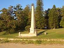
- Captain Cook Memorial Obelisk
- Sir Joseph Banks Memorial
- Solander Monument
- Sutherland Monument
The Discovery Centre provides information and displays relics from the early days in Kurnell’s history. Endeavour Heights is a recreation area in the Botany Bay National Park. The Kurnell Lookout provides brilliant views of Botany Bay and the northern headland of Botany Bay at La Perouse.
Cape Solander is popular amongst whale watchers during the migration season.
Commercial areas
The small residential area with a population of 2600 (as at 30/06/07 source ssec.org.au) is located to the north with a small group of shops in the village of Kurnell. Kurnell is dominated by an industrial area, which includes the Caltex Oil Refinery which is now closed and being converted into an import terminal to supply imported fuel for Australian customers. Refined petrol is piped to the other side of Botany Bay in an underwater pipeline. The Kurnell Desalination Plant, provides much of the rest of Sydney with an alternative water supply. It has been criticised on environmental grounds (greenhouse gases and impact of large amounts of deoxygenated brine), and was shelved, but was resumed after the March 2007 N.S.W. state elections. Continued widespread protest by residential, environmental, and community groups was declared to be irrelevant. Immediate work began on a pipeline under Botany Bay to carry desalinated water to northern suburbs and the size of the desalination plant was doubled.(source, smh.com.au-search. Desalination). Total water stored in the Sydney catchment was at a low of 36.9% on 7 June 2007 but rainfall increased volume stored to 64% as of 7 Feb 2008,[7] before reaching over 98% capacity in March 2012.[8] The water supply of Kurnell is supplemented with bore water.
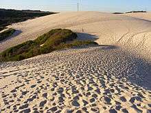
Sand mining on the peninsula has depleted the area of much of the sand that was originally there. It has been said that 40 metre deep pools now form in the dunes.[9] Pools are clearly visible in view from Google Earth. The remaining sand dune is used as a recreational off-road area for 4 wheel drives. The Cronulla sand dunes formed part of the location for the films Forty Thousand Horsemen, directed by Charles Chauvel in 1940 and Mad Max Beyond Thunderdome. Sand dunes are currently being replaced with domestic and industrial waste. The only road to Kurnell Peninsula is also flanked by a sewerage treatment plant.[10]
Transport
Transdev NSW operates bus route 987 Kurnell to Cronulla via North Cronulla.[11]
Sport and recreation
Triathlons are held in Kurnell annually. There are running tracks through Botany Bay National Park, as well as running along the beach and swimming in the netted area of Silver Beach. This location also offers fishing, sailing, scuba diving and windsurfing activities. There is a free shuttle bus service during whale watching season, departing from the parking area of the office of the National Park.
Boat Harbour Beach is the location of a 4WD park. Access can be gained via Captain Cook Drive. People are permitted to drive on the beach with their 4WDs. An entry fee is required and one may drive along the beach for at least two kilometres.

Gallery
 Kurnell flag masts at sunset
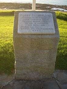 Sutherland's monument
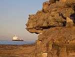 Kurnell sandstone cliffs, view towards Pacific Ocean
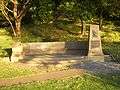 Sir Joseph Banks Memorial
References
- ↑ Australian Bureau of Statistics (31 October 2012). "Kurnell (State Suburb)". 2011 Census QuickStats. Retrieved 24 October 2013.
- ↑ http://www.kurnell.com/home.htm Kurnell
- ↑ Kurnell - A Pictorial History
- ↑ http://www.ssec.org.au/our_environment/our_bioregion/kurnell/history/index.htm Kurnell, a pictorial history
- 1 2 "Sydney residents in shock after tornado". SBS News. Special Broadcasting Service. 16 December 2015. Retrieved 16 December 2015.
- ↑ "Sydney tornado: Clean-up underway in Kurnell after 'unprecedented' storm delivers 213kph winds". ABC News. Australian Broadcasting Corporation. 16 December 2015. Retrieved 16 December 2015.
- ↑ Water storage and supply reports - Sydney Catchment Authority
- ↑ 8 March 2012 Water storage and supply reports - Sydney Catchment Authority
- ↑ The Kurnell Peninsula - Sand Dunes
- ↑ Kurnell Sand Dunes - 18 September 2003 - QWN - NSW Parliament
- ↑ Transdev NSW operates quality bus routes in the south and south west of Sydney Transdev NSW
Coordinates: 34°00′42″S 151°12′25″E / 34.01159°S 151.20686°E
| Wikimedia Commons has media related to Kurnell. |