Carlyon
Coordinates: 50°20′14″N 4°44′15″W / 50.33724°N 4.73742°W
See also: Carlyon Bay
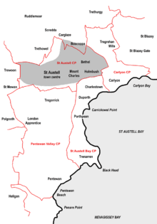
Sketch map of the four civil parishes in the St Austell area created in 2009 - click to enlarge
Carlyon (Cornish: Karleghyon,[1] meaning fort of rock-slabs) is one of four new civil parishes created on 1 April 2009 for the St Austell area of south Cornwall, England, United Kingdom.
The new parish is part coastal and part rural in character. It includes the settlements of Carlyon Bay, Garker and Tregrehan Mills and is represented by nine councillors.[2][3]
Carlyon Bay, the principal settlement in the parish, is approximately two miles (3 km) east of St Austell.[4]
References
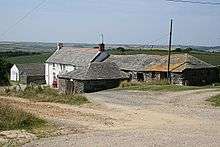
Carlyon Farm
- ↑ Place-names in the Standard Written Form (SWF) : List of place-names agreed by the MAGA Signage Panel Archived May 15, 2013, at the Wayback Machine.. Cornish Language Partnership.
- ↑ Cornwall Council website; Retrieved May 2010
- ↑ Cornwall; Explore Britain
- ↑ Ordnance Survey: Landranger map sheet 200 Newquay & Bodmin ISBN 978-0-319-22938-5
Cornwall Portal | |
| Unitary authorities | |
| Major settlements |
|
| Rivers | |
| Topics | |
Civil parishes of St Austell and Newquay constituency | ||
|---|---|---|
Cornwall Portal | ||
This article is issued from Wikipedia - version of the 11/18/2016. The text is available under the Creative Commons Attribution/Share Alike but additional terms may apply for the media files.