St Austell Bay
Coordinates: 50°19′41″N 4°45′55″W / 50.32804°N 4.76532°W

Looking south from Charlestown
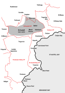
Map of the four civil parishes in the St Austell area created in 2009
click to enlarge
click to enlarge
St Austell Bay (Cornish: Baya Ti war Dreth)[1] is a bay on Cornwall's south coast which is bounded to the east by Gribbin Head and to the west by Black Head.[2]
Since 1 April 2009 it has also been the name of a civil parish, one of four new parishes created on for the St Austell area. It lies southeast of the town of St Austell[2] and stretches along the coast from Charlestown in the north to Black Head in the south. It includes the communities of Charlestown, Duporth, Porthpean (Higher and Lower Porthpean) and Trenarren and is represented by seven councillors.[3]
References
- ↑ Place-names in the Standard Written Form (SWF) : List of place-names agreed by the MAGA Signage Panel. Cornish Language Partnership.
- 1 2 Ordnance Survey: Landranger map sheet 200 Newquay & Bodmin ISBN 978-0-319-22938-5
- ↑ Cornwall Council website; Retrieved May 2010
External links
![]() Media related to St Austell Bay at Wikimedia Commons
Media related to St Austell Bay at Wikimedia Commons
Cornwall Portal | |
| Unitary authorities | |
| Major settlements |
|
| Rivers | |
| Topics | |
Civil parishes of St Austell and Newquay constituency | ||
|---|---|---|
Cornwall Portal | ||
This article is issued from Wikipedia - version of the 6/25/2015. The text is available under the Creative Commons Attribution/Share Alike but additional terms may apply for the media files.