Carmagnola
| Carmagnola | ||
|---|---|---|
| Comune | ||
| Città di Carmagnola | ||
|
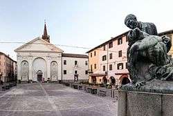
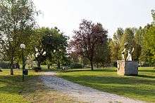
Sant'Agostino square, old town | ||
| ||
 Carmagnola Location of Carmagnola in Italy | ||
| Coordinates: 44°51′N 7°43′E / 44.850°N 7.717°E | ||
| Country | Italy | |
| Region | Piedmont | |
| Province / Metropolitan city | Turin (TO) | |
| Frazioni | San Bernardo, Salsasio, San Giovanni, San Michele Grato, Cappuccini, Casanova, Tuninetti, Vallongo, Motta e Corno | |
| Government | ||
| • Mayor | Ivana Gaveglio | |
| Area | ||
| • Total | 96.38 km2 (37.21 sq mi) | |
| Elevation | 240 m (790 ft) | |
| Population (31 August 2015)[1] | ||
| • Total | 29,033 | |
| • Density | 300/km2 (780/sq mi) | |
| Demonym(s) | Carmagnolesi | |
| Time zone | CET (UTC+1) | |
| • Summer (DST) | CEST (UTC+2) | |
| Postal code | 10022 | |
| Dialing code | 011 | |
| Patron saint | Immaculate Conception | |
| Saint day | December 8 | |
| Website | Official website | |
Carmagnola is a comune (municipality) in the Metropolitan City of Turin in the Italian region Piedmont, located 29 kilometres (18 mi) south of Turin.[2] The town is on the right side of the Po river. The nature of the soil determined, as time was passing, the accumulation of the river sands.
Carmagnola borders the following municipalities: Poirino, Villastellone, Carignano, Lombriasco, Ceresole Alba, Racconigi, Sommariva del Bosco, Caramagna Piemonte.
History
The municipality is mentioned for the first time during the 11th century. The land, originally owned by the Arduinic dynasty, passed to the Marquisate of Saluzzo, who had a castle built here. The Saluzzo dynasty soon underwent a rapid decadence ending with a French domination period which lasted 40 years. In 1588 Carmagnola became a possession of the House of Savoy, when Charles Emmanuel I besieged and conquered it. French took possession of Carmagnola a second time during the 17th century, during the civil war between Madamisti and Principisti (supporters of the French and the Savoy dynasty respectively). In this period (1637-1642), the three main subdivisions were razed to the ground as they were conflicting with the defence structures, and immediately re-built around 1.5 km from their original position, where they still are at the present time.
In 1690 the city was once again occupied by the French general Catinat, but just one year later Victor Amadeus II of Savoy brought it back among Piedmontese possessions. While its defence buildings were being demolished and its strategic role was progressively decreasing in importance, the town could finally develop agriculture and commerce, mainly of hemp and ropes, which were exported in great quantity to Liguria and souther France. The characteristic of both agricultural and commercial site remained important until after World War II, which caused a massive immigration and a rapid urbanistic expansion.
Main sights

- Abbey of Casanova. It was founded by the Cistercians in the 12th century, although it was mostly rebuilt in a late Baroque style in the 18th century
- Lomellini Palace, contemporary art museum
- Castle, currently used as town hall
- Collegiate church of Sts. Peter and Paul (1492-1514)
- Civic Museum of Natural History
Economy
The economy of the town is currently linked to the industry and intensive production of vegetables and cereals, which the particular soil makes very productive. Industry experienced a notable growth during the 1960s, when FIAT opened an important factory, thus attracting a growing number of immigrants from southern Italy. The rapid growth of FIAT made also possible other activities in the metallurgy, electronics, optics, chemical industry, and food industry fields. Also well-developed are the banking, financial and insurance sectors.
People
- Francesco Bussone da Carmagnola, better known as Il Carmagnola - Renaissance condottiero.
- Enrico Saroldi - sculptor
- Antonio Tortone - sculptor
- Guglielmo Diatto - 19th century founder of the Diatto industrial enterprise.
- Francesca Maria Rubatto - Catholic nun, founder of the Capuchin Sisters of Mother Rubatto
Events
- Peppers Fair. It is held between the last week of August and the first of September; it is an eno-gastronomic fair dedicated to the most typical product of Carmagnola's agriculture. It attracts over 250,000 visitors each year.
- Spring Fair (Fiera di primavera). Held annually in March, dedicated to agricultural commerce, it features many collateral events.
Twin towns
References
- ↑ All demographics and other statistics: Italian statistical institute Istat.
- ↑
 Chisholm, Hugh, ed. (1911). "Carmagnola". Encyclopædia Britannica (11th ed.). Cambridge University Press.
 - ↑ http://www.aquinoticias.com.ar/index.php?id=7600 Río Tercero (spanish)