Rorà
| Rorà | ||
|---|---|---|
| Comune | ||
| Comune di Rorà | ||
 | ||
| ||
 Rorà Location of Rorà in Italy | ||
| Coordinates: 44°48′N 7°12′E / 44.800°N 7.200°E | ||
| Country | Italy | |
| Region | Piedmont | |
| Province / Metropolitan city | Turin (TO) | |
| Frazioni | Ruà | |
| Government | ||
| • Mayor | Giorgio Odetto | |
| Area | ||
| • Total | 12.3 km2 (4.7 sq mi) | |
| Elevation | 967 m (3,173 ft) | |
| Population (31 December 2010)[1] | ||
| • Total | 251 | |
| • Density | 20/km2 (53/sq mi) | |
| Demonym(s) | Rorenghi | |
| Time zone | CET (UTC+1) | |
| • Summer (DST) | CEST (UTC+2) | |
| Postal code | 10060 | |
| Dialing code | 0121 | |
Rorà is a comune (municipality) in the Province of Turin in the Italian region Piedmont, located about 50 km southwest of Turin.
It was the scene of several campaigns against the Waldensians and is historically linked to Joshua Janavel.[2] Nearby Torre Pellice is the center of the Waldensian church.
Rorà borders the following municipalities: Villar Pellice, Torre Pellice, Luserna San Giovanni, and Bagnolo Piemonte.
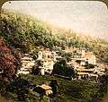
 Village of Rorà, abt. 1895
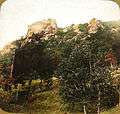
 Scene of Jeneval's victory above Rorà.
 Scene of the victory above Rorà.
.jpg) Road on the way to Rorà, abt. 1895
Road on the way to Rorà, abt. 1895 Map of the Waldensian Valley
References
- ↑ Demographic data from Istat
- ↑ "A short history of the Waldensian church in the valleys of Piedmont, from the earliest period to the present time, by Jane Louisa Willyams". Nisbet. 1855. Retrieved January 2016. Check date values in:
|access-date=(help)
This article is issued from Wikipedia - version of the 10/8/2016. The text is available under the Creative Commons Attribution/Share Alike but additional terms may apply for the media files.
