Caroline Island
Coordinates: 9°56′13.13″S 150°12′41.40″W / 9.9369806°S 150.2115000°W
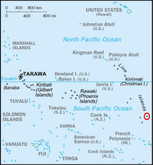
Caroline Island or Caroline Atoll (also known as Millennium Island and Beccisa Island), is the easternmost of the uninhabited coral atolls which comprise the southern Line Islands in the central Pacific Ocean.
First sighted by Europeans in 1606, claimed by the United Kingdom in 1868, and part of the Republic of Kiribati since the island nation's independence in 1979, Caroline Island has remained relatively untouched and is considered one of the world's most pristine tropical islands, despite guano mining, copra harvesting, and human habitation in the 19th and 20th centuries. It is home to one of the world's largest populations of the coconut crab and is an important breeding site for seabirds, most notably the sooty tern.
The atoll is currently designated as a wildlife sanctuary.[1] In 2014 the Kiribati government established a 12-nautical-mile fishing exclusion zone around each of the southern Line Islands (Caroline (commonly called Millennium), Flint, Vostok, Malden, and Starbuck).[2]
The atoll is best known for its role in the millennium celebrations. A 1995 realignment of the International Date Line made Caroline Island one of the first points of land on Earth to reach January 1, 2000 on the calendar.
Geography and climate
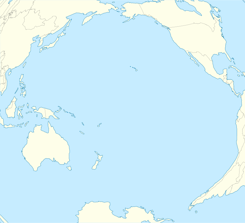
Caroline Atoll lies near the southeastern end of the Line Islands, a string of atolls extending across the equator some 1,500 km (930 mi) south of the Hawaiian Islands in the central Pacific. The slightly crescent-shaped atoll (3.76 km2 or 1.45 mi2 in land area) consists of 39 separate islets surrounding a narrow lagoon, 8.7 by 1.2 km2 in size, or with an area of 6.3 km2. The total atoll area, including dry land, lagoon and reef flat, measures 13 by 2.5 km, or 24 km2. The islets rise to a height of only 6 meters (20 feet) above sea level. The islets, like those of all atolls, share a common geologic origin and consist of sand deposits and limestone rock set atop a coral reef. According to the path of the International Date Line, Caroline Island is the easternmost point of land on Earth.
Three large islets make up the bulk of Caroline's land area: Nake Islet (1.04 km2 or 0.40 mi2) at the north; Long Islet (0.76 km2 or 0.29 mi2) at the northeast of the lagoon and South Islet (1.07 km2 or 0.41 mi2).[3] The remaining assembly of small islets, most of which were named during the 1988 ecological survey, conducted by Angela and Cameron Kepler, fall into four major groupings: the South Nake Islets, the Central Leeward Islets, the Southern Leeward Islets, and the Windward Islets (see map at the Wayback Machine (archived December 23, 2010)). Caroline's islets are particularly ephemeral— over the course of a century of observation, several of the smallest islets have been documented to appear or disappear entirely following major storms, while the shapes of larger ones have significantly changed.[3][4]
The central lagoon, roughly 6 by 0.5 km (3.73 by 0.31 mi), is shallow – at most 5–7 m (16–23 ft) in depth – and is crossed repeatedly by narrow coral heads and patch reefs. Reef flats generally extend about 500 m (1,600 ft) from shore— although some sources report them to extend more than a kilometer from land— and make boat landings perilous except at high tide.[3] There are no natural landings, anchorages, or deep water openings into the central lagoon; water which spills into the lagoon over shallow channels at high tide is contained within the surrounding reef and remains stable despite ocean tides. Most landings are generally made at a small break in the reef at the northwest corner of the South Islet (visible on the satellite photo above).[4]
Densities of giant clams reach up to four per square foot in parts of the lagoon.[2] The most common species is the “small giant clam” Tridacna maxima and largest clam species, Tridacna gigas is also found in the lagoon.[2]
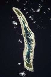
There is no standing fresh water on Caroline Island, although the Nake and South Islets harbor underground freshwater aquifers (or Ghyben-Herzberg lenses),[5] and wells have been built to tap drinking water for temporary settlements.[6] Soils on Caroline are similarly poor, dominated by coral gravel and sand, with significant organic content present only within stable, forested island centers. Guano deposits make island soil, where it does exist, nitrogen-rich; but even in the oldest and most vegetated regions of the atoll, soils are only a few centimeters (one or two inches) thick.[4]
Like the rest of Kiribati, Caroline Island enjoys a tropical maritime climate which is consistently hot and humid. Meteorological records are sparse, but temperatures generally range between 28 and 32 degrees Celsius (82 and 90 degrees Fahrenheit) year round.[7] Caroline lies within a region of highly variable precipitation, but is estimated to receive an average of 1,500 mm (59 in) of rain annually. Tides are on the order of 0.5 m (1.6 ft) and trade winds, generally from the northeast, mean that corner of the island experiences the roughest seas.[4]
Caroline Island is among the most remote islands on earth[8]–230 km (140 mi) from the closest land at Flint Island, 1,500 km (930 mi) from the nearest permanent settlement on Kiritimati, 4,200 km (2,600 mi) from the Kiribati capital of Tarawa, and 5,100 km (3,200 mi) from the nearest continental land in North America.
Flora and fauna
Despite more than three centuries of occasional human impact on Caroline, it is considered to be one of very few remaining "near-pristine tropical islands."[5] and has been rated as one of the most unspoiled Pacific atolls.[9] Its relatively undisturbed state has led to Caroline being considered for designation as a World Heritage Site and as a Biosphere Reserve. Ecological surveys documenting the island's flora and fauna have been made intermittently through the later 20th century: Caroline was visited in 1965 by the Pacific Ocean Biological Survey Program, in 1974 by the Line Island Expedition, and in 1988 and 1991 by the United Nations Environment Programme Wildlife Conservation Unit.[10]
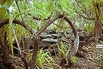
Caroline Island is heavily vegetated, and most islets possess three ringed zones of vegetation: an outermost herb mat, typically composed mainly of Heliotropium anomalum; an inward zone of shrub, primarily Heliotropium foertherianum; and a central forested region, typically dominated by groves of Pisonia grandis trees. Coconut palms have also been introduced and exist in substantial quantities on the larger islets. This pattern of vegetation is consistent across the larger islets, with smaller islets lacking the central forest and the smallest vegetated solely by low herbs.[4] Other common plants include Suriana maritima and Morinda citrifolia.[11]
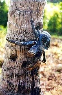
Caroline Island is an important breeding site for a number of species of seabirds, most notably the sooty tern (Onychoprion fuscata), numbering around 500,000 – a colony of sooty terns dominates the eastern islets – and the great frigatebird (Fregata minor), numbering over 10,000. Caroline Island and its neighbor, Flint Island, also host some of the world's largest populations of the coconut crab. (Birgus latro).[3] Other native animals include the Tridacna clam, which is abundant in the central lagoon, hermit crabs, and multiple species of lizards.[11]
The endangered green turtle (Chelonia mydas) nests on the beaches of Caroline Island, but there have been reports of poaching by recent homesteaders.[11] The bristle-thighed curlew (Numenius tahitiensis), a migrant visitor from Alaska, is also classified as vulnerable.[5]
Around twenty non-native species of flora have been introduced to Caroline Island via human contact. Among these are the vine Ipomoea violacea, which has begun to proliferate. Domestic cats and dogs introduced alongside a small homestead have driven the seabird population away from the islet of Monu Ata-Ata.[5]
History
Prehistory
Caroline Island is believed to have originated from a volcanic hotspot which eroded and then become home to a coral reef which grew above the ocean surface. Although these geological processes are poorly understood, the orientation of the Line Islands (roughly north-south) suggests that they were formed more than 40 million years ago, before the Pacific Plate changed its direction of travel. The same hotspot more recently gave rise to the Tuamotu Archipelago.[12]
There is evidence of settlement by Polynesian peoples on the largest islets from before European contact.[4] Graves and template platforms were uncovered by early expeditions to the island, and a large marae exists on the west side of Nake Islet.[6] To date, these artifacts have not been surveyed by archaeologists.
17th to 19th century
The first recorded sighting of Caroline Island by Europeans was on February 21, 1606, by Pedro Fernández de Quirós, a Portuguese explorer sailing on behalf of Spain; his account names the island "San Bernardo."[4] The atoll was "rediscovered" on December 16, 1795 by Captain William Robert Broughton of HMS Providence, who gave the atoll the name Carolina (which later became Caroline) "in compliment to the daughter of Sir P. Stephens of the Admiralty."[4] Caroline was again sighted in 1821 by the English whaling ship Supply and was then named "Thornton Island" for the ship's captain. Other early names for the atoll include Hirst Island, Clark Island, and Independence Island. Among other early visits which left behind accounts of the island are that of the USS Dolphin in 1825 (recorded by Lieutenant Hiram Paulding), and of a whaling ship in 1835 (recorded by Frederick Debell Bennett in his Narrative of a Whaling Voyage Round the Globe From the Year 1833–1836).
In 1846, the Tahitian firm of Collie and Lucett attempted to establish a small stock-raising and copra (coconut meat) community on the island, an operation which met with limited financial success. In 1868, Caroline was claimed by the British vessel HMS Reindeer, which noted 27 residents in a settlement on South Islet. This settlement lasted until 1904, when the six remaining Polynesians were relocated to Niue.[4]
In 1872, the island was leased by the British government to Houlder Brothers, who conducted minimal guano mining on the island. In 1881, the lease was later taken over by the mining operation's manager, John T. Arundel (for whom one of the islets is named).[6] Guano mining, which began in 1874, supplied a total of about 10,000 tons of phosphate until supplies were exhausted around 1895.[4]
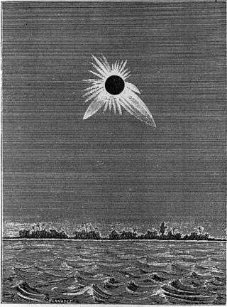
In 1883, an expedition of American astronomers traveled from Peru to Caroline Island aboard the USS Hartford to observe a total solar eclipse on May 6. A French expedition also observed the eclipse from Caroline, and the United States Navy mapped the atoll.[6] Johann Palisa, a member of the expedition, discovered an asteroid later that year which he named Carolina "in remembrance of his visit to [the] island."[13]
20th century
Leased to S.R. Maxwell and Company, a new settlement was established in 1916, this time built entirely upon copra export. Much of the South islet was deforested to make way for coconut palms, a non-indigenous plant.[4] The business venture, however, went into debt, and the island's settlement slowly decreased in population. By 1926, it was down to only ten residents and by 1936, the settlement consisted of only two Tahitian families before abandonment sometime in the late 1930s.[6]
Caroline Island remained uninhabited and undisturbed through World War II and afterwards. It remained under British jurisdiction, repossessed by the British Western Pacific High Commission in 1943 and governed as part of the Central and Southern Line Islands. In January 1972, the Central and Southern Line Islands, including Caroline, were joined with the British colony of the Gilbert and Ellice Islands, which had become autonomous in 1971 as part of British decolonization efforts.[14]
In 1979, the Gilbert Islands became the independent nation of Kiribati; Caroline Island is Kiribati's easternmost point. The entire island is owned by the government of the Republic of Kiribati, overseen by the Ministry of Line and Phoenix Groups, which is headquartered on Kiritimati. Competing claims to sovereignty over the island by the United States (under the Guano Islands Act) were relinquished in the 1979 Treaty of Tarawa, ratified by the U.S. Senate in 1983.[15]
The island was briefly inhabited again from 1987 to 1991 by Ron Falconer, his wife Anne, and their two children, who developed a largely self-sufficient settlement on the atoll. Following a transfer of ownership, Falconer was evicted from the island by the Kiribati government. A book, Together Alone (ISBN 1-86325-428-5), written by Falconer, documents the story of their residence on Caroline Island.[16]
In the 1990s, the island was leased to Urima Felix, a French Polynesian entrepreneur; he established a small homestead on one of the islets and reportedly had plans for development of the atoll. The island is also occasionally visited by Polynesian copra gatherers under agreements with the Kiribati government in Tarawa.[10]
Time zone realignment
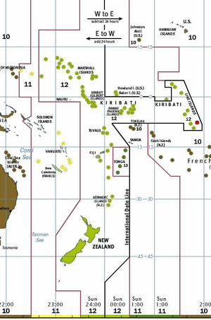
On December 23, 1994, the Republic of Kiribati announced a change of time zone for the Line Islands, to take effect January 1, 1995. This adjustment effectively moved the International Date Line over 1,000 kilometers (620 mi) to the east within Kiribati, placing all of Kiribati on the Asian or western side of the date line, despite the fact that Caroline's longitude of 150 degrees west corresponds to UTC−10 rather than its official time zone of UTC+14. Caroline Island now is at the same time as the Hawaiian Islands (Hawaii-Aleutian Standard Time Zone), but one day ahead.[17] This move made Caroline Island both the easternmost land in the earliest time zone (by some definitions, the easternmost point on Earth), and one of the first points of land which would see sunrise on January 1, 2000 — at 5:43 a.m., as measured by local time.
The stated reason for the move was a campaign promise of Kiribati President Teburoro Tito to eliminate the confusion of Kiribati straddling the Date Line and therefore being constantly in two different days. However, Kiribati officials were not reluctant to attempt to capitalize on the nation's new status as owners of the first land to see sunrise in 2000.[18] Other Pacific nations, including Tonga and New Zealand's Chatham Islands, protested the move, objecting that it infringed on their claims to be the first land to see dawn in the year 2000.[19]
In 1999, in order to further capitalize upon the massive public interest in celebrations marking the arrival of the year 2000, Caroline Island was officially renamed Millennium Island. Although uninhabited, a special celebration was held on the island, featuring performances by Kiribati native entertainers and attended by Kiribati president Tito.[20] Over 70 Kiribati singers and dancers traveled to Caroline from the capital Tarawa,[21] accompanied by approximately 25 journalists. The celebration, broadcast by satellite worldwide, had an estimated audience of up to one billion viewers.[20]
Despite many media and government claims to the contrary, Caroline Island was not the first point of land to see sunrise on January 1, 2000 (local time); that distinction belongs to a point of land between Dibble Glacier and Victor Bay on the coast of East Antarctica, at 66°03′S 135°53′E / 66.050°S 135.883°E, where the sun rose 35 minutes earlier.[22] As this point is close to the Antarctic Circle, and the area beyond the Antarctic Circle is affected by the continuous sunlight in December, the definition of the exact point becomes a question of distinguishing between a sunset and an immediate sunrise in view of atmospheric refraction effects.
21st century and future
As Caroline Island only extends six meters above sea level, it would be in danger if sea levels rise. The Kiribati government estimates that the island may be reclaimed by the sea as soon as 2025,[21] and the United Nations has rated Caroline Island as among those most in danger from sea level rise.[23]
Image gallery
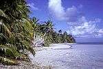 Lagoon side of South Islet, Caroline Atoll
 Lagoon on Caroline Atoll
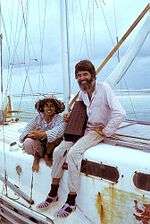 Ron and Anne Falconer, who lived on Caroline Atoll 1988-92
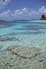 Clear lagoon shallows, Caroline Atoll
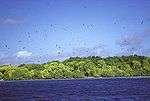 Brothers Islet, Caroline Atoll
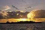 Sunset over Fishball Islet, Caroline Atoll
- Channel between Long Islet and Nake Islet, Caroline Atoll
 Ancient Polynesian marae, Caroline Atoll
 Cordia trees on North Arundel Islet, Caroline Atoll
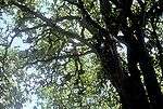 Psionia trees on Caroline Atoll
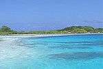 Shark Islet on Caroline Atoll
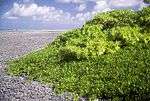 Scaevola thicket on Windward Islet, Caroline Atoll
Footnotes
- ↑ Edward R. Lovell, Taratau Kirata & Tooti Tekinaiti (September 2002). "Status report for Kiribati's coral reefs" (PDF). Centre IRD de Nouméa. Retrieved 15 May 2015.
- 1 2 3 Warne, Kennedy (September 2014). "A World Apart – The Southern Line Islands". National Geographic. Retrieved 15 May 2015.
- 1 2 3 4 "Line Islands - Millennium". Oceandots.com. Archived from the original on 2010-12-23. Retrieved 2006-06-11.
- 1 2 3 4 5 6 7 8 9 10 11 Kepler, Angela K.; Cameron B. Kepler (February 1994). "The natural history of the Caroline Atoll, Southern Line Islands" (PDF). Atoll Research Bulletin. 397–398. Archived from the original (PDF) on 2009-09-18.
- 1 2 3 4 "Millennium Atoll". Living Archipelagos. Retrieved 2006-06-10.
- 1 2 3 4 5 Bryan, E.H. (1942). American Polynesia and the Hawaiian Chain. Honolulu: Tongg Publishing Company.
- ↑ "Republic of Kiribati". Atlapedia Online. Retrieved 2006-07-12.
- ↑ "More Isolated Islands". Island Directory Tables. U.N. Earthwatch. Retrieved 2006-06-12.
- ↑ "Islands by Human Impact Index". U.N. Earthwatch Island Directory Tables. Retrieved 2006-07-05.
- 1 2 Scott, Derek A. (ed) (1993). A Directory of Wetlands in Oceania. Slimbridge, UK: International Waterfowl and Wetlands Research Bureau. ISBN 0-9505731-2-4.
- 1 2 3 Teataata, Aobure (1998). "Caroline Atoll". Protected Areas and World Heritage Programme Profiles. Archived from the original on 2008-02-10.
- ↑ "Pacific Ocean - Line Islands". Oceandots.com. Archived from the original on 2010-12-23. Retrieved 2006-06-11.
- ↑ Schmadel, L.D. (2000). Dictionary of Minor Planet Names (4th ed.). Berlin: Springer-Verlag Telos. ISBN 3-540-66292-8.
- ↑ Gwillim Law (2005). "Island Groups of Kiribati". Statoids.
- ↑ "Treaty of Friendship Between the United States of America and the Republic of Kiribati". 1979.
- ↑ Falconer, Ron (2004). Together Alone. Australia: Bantam Books. ISBN 1-86325-428-5.
- ↑ Harris, Aimee (August 1999). "Date Line Politics". Honolulu Magazine. p. 20. Retrieved 2006-06-10.
- ↑ Kristof, Nicholas D. (March 23, 1997). "Tiny Island's Date-Line Jog in Race for Millennium". New York Times. Retrieved 2006-06-10.
- ↑ Letts, Quentin (January 25, 1996). "Pacific braces for millennium storm over matter of degrees". The Times. Retrieved 2006-06-10.
- 1 2 "2000 greeted with song, dance". Japan Times. Associated Press. January 1, 2000.
- 1 2 "Millennium Island greets Y2K warmly". ClimateArk.org. Associated Press. December 30, 1999. Archived from the original on February 13, 2005. Retrieved 2006-06-11.
- ↑ "Islands of Kiribati". U.N. Earthwatch Islands Directory. Retrieved 2006-06-11.
References
- Bennett, Frederick Debell (1970). Narrative of a Whaling Voyage Round the Globe From the Year 1833–1836. New York: Da Capo Press. ISBN 90-6072-037-7.
- Bryan, E. H. (1942). American Polynesia and the Hawaiian Chain. Honolulu: Tongg Publishing Company. (Text of "Caroline Island" chapter online at: "Caroline Island (Millennium Island), Line Islands, Republic of Kiribati". Jane's Oceania Home Page.)
- Falconer, Ron (2004). Together Alone. Australia: Bantam Books. ISBN 1-86325-428-5.
- Kepler, A. K.; Kepler, C. B. (February 1994). "The natural history of the Caroline Atoll, Southern Line Islands" (PDF). Atoll Research Bulletin. 397–398. Archived from the original (PDF) on 2009-09-18.
- Scott, D. A. (1993). A Directory of Wetlands in Oceania. Slimbridge, UK: International Waterfowl and Wetlands Research Bureau. ISBN 0-9505731-2-4. (Text of "Caroline Island" profile online at: "Caroline Atoll". Protected Areas and World Heritage Programme Profiles. Archived from the original on 2008-02-10.)
External links
- National Geographic - Southern Line Islands Expedition, 2014
- UNEP Protected Areas Program Profile at the Wayback Machine (archived February 13, 2008)
- Living Archipelagos Profile
- Oceandots: Caroline Island at the Wayback Machine (archived December 23, 2010)
- "High-resolution photo map of Caroline Island". Archived from the original on 2010-12-23. Retrieved 2009-03-14.
- Millennium Celebrations on Millennium Island at Jane's Oceania Home Page
- An Astronomer's Voyage to Fairy-Land, from The Young Folks' Library, Volume XI, by Prof. E.S. Holden
- The Looking for Nemo Expedition, by Wayne and Karen Brown.
| Gilbert Islands |  | |
|---|---|---|
| Phoenix Islands | ||
| Line Islands | ||
| West of Gilberts | ||
| Reefs | ||
| ||