Carrick (Pittsburgh)
| Carrick | |
|---|---|
|
Neighborhood of Pittsburgh Former Borough | |
|
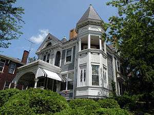
Wigman House, built in 1888, on Brownsville Road in Carrick | |
 | |
| Coordinates: 40°23′49″N 79°59′13″W / 40.397°N 79.987°W | |
| Country | United States |
| State | Pennsylvania |
| County | Allegheny County |
| City | Pittsburgh |
| Incorporated | 1904[1] |
| Area[2] | |
| • Total | 1.673 sq mi (4.33 km2) |
| Population (2010)[2] | |
| • Total | 10,113 |
| • Density | 6,000/sq mi (2,300/km2) |
| ZIP Code | 15227, 15210 |
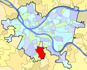
Carrick is a south neighborhood of Pittsburgh, Pennsylvania in the United States. It is served by two zip codes, 15210 and 15227, and has representation on Pittsburgh City Council by the council member for District 4 (South Neighborhoods) with a part in District 3.
Located between the suburbs of the South Hills and downtown, Carrick is well-served by public transportation. Once home to prominent mansions and wealthy families, the neighborhood currently has an affordable, solid housing stock and remains family-oriented.
Geography
Carrick is located on the southeastern edge of the City of Pittsburgh. It is situated atop a crest west of the Monongahela River. It is surrounded by (clockwise from the north) Knoxville, Mt. Oliver Borough, Mt. Oliver, St. Clair, Baldwin Borough, Brentwood Borough, Overbrook, Brookline, Bon Air.
Brownsville Road runs across the top of the crest and is the main thoroughfare through the neighborhood. The Carrick section of Brownsville Road is approximately 2.2 miles (3.5 km) long; it generally comprises three discrete business districts with residential areas in between.
History
Carrick was originally part of the land grant to Major John Ormsby from King George III in 1763 for his service during the French and Indian War. Carrick and Mt. Oliver were once known as the Ormsby Tract or simply Ormsby.[3] The city of Birmingham was organized on this land by Ormsby's son in law Nathanial Bedford.[4] It became known for coal mines and a glassworks in the Crailo area, also known as Spiketown, near the Presbyterian Church and Volunteers Field.
In 1853, Dr. John H. O'Brien received permission from the United States Postal Service to establish a post office in the area; for his hard work he was given the honor of naming it, and he chose "Carrick" after his home town, Carrick-on-Suir, Ireland. Carrick became a Borough in 1904 and in 1926 voted to become part of the City of Pittsburgh. In 1927 it officially became known as the 29th Ward.
Public facilities
The neighborhood boasts of numerous parklet playgrounds, the Carnegie Library of Carrick, historic Phillips Park (comprising walking paths, a disc golf course, a recreation center and swimming pool) and Volunteers Field (comprising a baseball-only field and a multipurpose athletic field).
In 1997, Carrick was named the first "Cool Community in the northern United States by the U.S. Department of Energy. "Cool Community" is a national recognition program for strategic treeplanting for energy conservation purposes. Partnering with conservation organizations, community groups worked to weatherize homes and businesses, plant trees and flowers, and add elements of "green building" to the renovation of Carrick High School.
The Pittsburgh Bureau of Fire houses 23 Engine in Carrick. 23 Engine is a 75-foot (23 m) Pierce quint.
Education
- Carrick High School
- Concord Elementary School
- Roosevelt Elementary School
Places of worship
Carrick includes Roman Catholic, Protestant, Evangelical, Jehovah's Witness, Lutheran, and Byzantine Catholic places of worship.[5]
See also
References
- ↑ https://books.google.com/books?id=2eYKAAAAYAAJ&pg=PA107&lpg=PA107&dq=incorporated+%22Borough+of+Carrick%22&source=bl&ots=s90SuDzQG_&sig=nqZ0iFzi6-owUtqBVcqcyt4eEO0&hl=en&sa=X&ved=0ahUKEwiv2JaU2OTNAhVT2GMKHZRyD-kQ6AEIIjAB#v=onepage&q=incorporated%20%22Borough%20of%20Carrick%22&f=false
- 1 2 "PGHSNAP 2010 Raw Census Data by Neighborhood". Pittsburgh Department of City Planning PGHSNAP Utility. 2012. Retrieved 21 June 2013. External link in
|publisher=(help) - ↑ Spotlight on Mainstreet
- ↑ Historic Pittsburgh
- ↑ Merchant Circle
Further reading
- Toker, Franklin (1994) [1986]. Pittsburgh: An Urban Portrait. Pittsburgh: University of Pittsburgh Press. ISBN 0-8229-5434-6.
External links
- Carrick-Overbrook Historical Society
- Interactive Pittsburgh Neighborhoods Map
- Pittsburgh City Council District 3 Summary