Allentown (Pittsburgh)
| Allentown | |
|---|---|
|
Neighborhood of Pittsburgh Former Borough | |
|
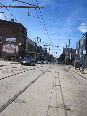
East Warrington Avenue, Allentown, Pittsburgh | |
 | |
| Coordinates: 40°25′16″N 79°59′38″W / 40.421°N 79.994°W | |
| Country | United States |
| State | Pennsylvania |
| County | Allegheny County |
| City | Pittsburgh |
| Area[1] | |
| • Total | 0.295 sq mi (0.76 km2) |
| Population (2010)[2] | |
| • Total | 2,500 |
| • Density | 8,500/sq mi (3,300/km2) |
| ZIP Code | 15203, 15210 |
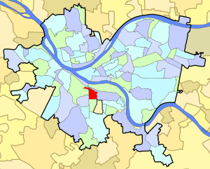
Allentown is a south neighborhood of Pittsburgh, Pennsylvania, in the United States. The zip code used by residents is 15210, and has representation on the Pittsburgh City Council by the council member for District 3 (Central South Neighborhoods).
History
Beltzhoover Avenue is a north-south thoroughfare that separates Allentown and Knoxville (to the east) from Beltzhoover and Mt. Washington (to the west). The city of Pittsburgh expanded and absorbed these areas lying southward of the original city of Pittsburgh.
Allentown was carved out of St. Clair Township, which was one of the original townships of Allegheny County. On April 26, 1827, Joseph Allen, an Englishman, purchased the land that would eventually be known as Allentown from Jeremiah Warder. Incorporated on March 2, 1870 and annexed by the City of Pittsburgh on April 2, 1872, Allentown was settled by many skilled German immigrants who established businesses. Welsh, Irish, and English settlers made up the second largest immigrant population.
Allentown developed quickly due to its convenient location to downtown Pittsburgh as well as due to the available transportation. Two main roads south from Pittsburgh merged on the hilltop in Allentown: Washington Road (today’s Warrington Avenue) and Brownsville Turnpike Road (today’s Arlington Avenue). The neighborhoods were connected at first by horse-drawn streetcars and later by the electric streetcar. In 1888 Allentown became the first site west of the Allegheny Mountains to operate an electric streetcar. Ever since then the trolley, or ‘T’, has run through the neighborhood of Allentown, keeping the hilltop residents connected to downtown Pittsburgh. In the past there were five inclines that served Allentown, the most famous of which was the curved Knoxville incline with a station at the intersection of Warrington and Arlington. Today the T line is used primarily as an emergency route when the South Hills Transit Tunnel is down for some reason, several bus routes, and many more roads connect the neighborhood with the downtown, South Side, and beyond.
| Historical population | |||
|---|---|---|---|
| Census | Pop. | %± | |
| 1940 | 8,227 | — | |
| 1950 | 7,487 | −9.0% | |
| 1960 | 6,416 | −14.3% | |
| 1970 | 5,361 | −16.4% | |
| 1980 | 4,292 | −19.9% | |
| 1990 | 3,600 | −16.1% | |
| 2000 | 3,220 | −10.6% | |
| 2010 | 2,500 | −22.4% | |
| [3][2] | |||
See also
References
- ↑ "Census: Pittsburgh". Pittsburgh Department of City Planning. April 2013. Retrieved 2013-04-26.
- 1 2 "Census: Pittsburgh" (PDF). Pittsburgh Department of City Planning. January 2006. Archived from the original (PDF) on August 10, 2007. Retrieved 2007-07-19.
- ↑ https://docs.google.com/spreadsheet/ccc?key=0Ag0xdSSLPcUHdEo0STlkRVBpcVZEcUtwTG9wWjJTd2c#gid=0
Further reading
- Toker, Franklin (1994) [1986]. Pittsburgh: An Urban Portrait. Pittsburgh: University of Pittsburgh Press. ISBN 0-8229-5434-6.