East Carnegie (Pittsburgh)
| East Carnegie | |
|---|---|
| Neighborhood of Pittsburgh | |
 | |
| Coordinates: 40°25′12″N 80°04′16″W / 40.420°N 80.071°W | |
| Country | United States |
| State | Pennsylvania |
| County | Allegheny County |
| City | Pittsburgh |
| Area[1] | |
| • Total | 0.432 sq mi (1.12 km2) |
| Population (2010)[1] | |
| • Total | 570 |
| • Density | 1,300/sq mi (510/km2) |
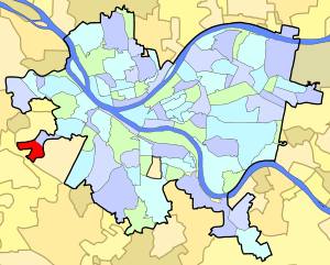
East Carnegie is a neighborhood located southwest of downtown Pittsburgh, Pennsylvania adjacent to the neighborhood of Oakwood. It is a “natural area” with the majority of the residences located in the City of Pittsburgh.
Most of East Carnegie uses a post office zipcode of 15106, while a small part of this neighborhood uses a zipcode of 15205. Residents residing within City of Pittsburgh boundaries have representation on Pittsburgh City Council by the council member for District 2 (West Neighborhoods). The remaining residents are represented by their respective borough councils.
Surrounding neighborhoods
Oakwood (Pittsburgh), Scott Township, Greentree, Crafton
See also
References
- 1 2 "PGHSNAP 2010 Raw Census Data by Neighborhood". Pittsburgh Department of City Planning PGHSNAP Utility. 2012. Retrieved 24 June 2013. External link in
|publisher=(help)
Further reading
- Toker, Franklin (1994) [1986]. Pittsburgh: An Urban Portrait. Pittsburgh: University of Pittsburgh Press. ISBN 0-8229-5434-6.
External links
This article is issued from Wikipedia - version of the 10/10/2016. The text is available under the Creative Commons Attribution/Share Alike but additional terms may apply for the media files.