Carrollton, Mississippi
| Carrollton, Mississippi | |
|---|---|
| Town | |
|
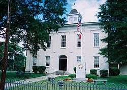
Carroll County Courthouse in Carrollton | |
 Location of Carrollton, Mississippi | |
| Coordinates: 33°30′18″N 89°55′22″W / 33.50500°N 89.92278°WCoordinates: 33°30′18″N 89°55′22″W / 33.50500°N 89.92278°W | |
| Country | United States |
| State | Mississippi |
| County | Carroll |
| Area | |
| • Total | 0.8 sq mi (2.0 km2) |
| • Land | 0.8 sq mi (2.0 km2) |
| • Water | 0.0 sq mi (0.0 km2) |
| Elevation | 289 ft (88 m) |
| Population (2010) | |
| • Total | 190 |
| • Density | 243/sq mi (94.0/km2) |
| Time zone | Central (CST) (UTC-6) |
| • Summer (DST) | CDT (UTC-5) |
| ZIP code | 38917 |
| Area code(s) | 662 |
| FIPS code | 28-11580 |
| GNIS feature ID | 0668097 |
| Website |
www |
Carrollton is a town in and the county seat of Carroll County, Mississippi, United States. The population was 190 at the 2010 census,[1] down from 408 at the 2000 census. The only incorporated place in Mississippi with a lower population is Walthall (population: 144), the county seat of Webster County. It is part of the Greenwood, Mississippi micropolitan area.
As of July 23, 2016, Carrollton still flies, at full mast, the Confederate Battle Flag, The Battle Flag of the Army of Northern Virginia, above the county memorial to the Confederate dead.
Geography
Carrollton is located in central Carroll County on the south side of Big Sand Creek, a tributary of the Yalobusha River. The town borders North Carrollton, which is located directly to the north across the creek. Mississippi Highways 17 and 35 pass through the center of Carrollton, leading north into North Carrollton. Highway 35 continues north 21 miles (34 km) to Holcomb and leads southeast 18 miles (29 km) to Vaiden, while Highway 17 leads south 30 miles (48 km) to Lexington. U.S. Route 82, a four-lane divided highway, passes through the southern part of Carrollton, leading east 11 miles (18 km) to Winona and west 18 miles (29 km) to Greenwood. According to the United States Census Bureau, Carrollton has a total area of 0.8 square miles (2.1 km2), all land.
Many residents of Carrollton and North Carrollton consider the towns a single entity, simply referred to as Carrollton.[2]
Demographics
| Historical population | |||
|---|---|---|---|
| Census | Pop. | %± | |
| 1860 | 718 | — | |
| 1870 | 377 | −47.5% | |
| 1880 | 394 | 4.5% | |
| 1890 | 488 | 23.9% | |
| 1900 | 540 | 10.7% | |
| 1910 | 608 | 12.6% | |
| 1920 | 510 | −16.1% | |
| 1930 | 523 | 2.5% | |
| 1940 | 575 | 9.9% | |
| 1950 | 475 | −17.4% | |
| 1960 | 343 | −27.8% | |
| 1970 | 295 | −14.0% | |
| 1980 | 338 | 14.6% | |
| 1990 | 221 | −34.6% | |
| 2000 | 408 | 84.6% | |
| 2010 | 190 | −53.4% | |
| Est. 2015 | 182 | [3] | −4.2% |
As of the census[5] of 2000, there were 408 people, 85 households, and 62 families residing in the town. The population density was 522.0 people per square mile (202.0/km²). There were 99 housing units at an average density of 126.7 per square mile (49.0/km²). The racial makeup of the town was 50.00% White and 50.00% African American. Hispanic or Latino of any race were 0.49% of the population.
There were 85 households out of which 24.7% had children under the age of 18 living with them, 57.6% were married couples living together, 10.6% had a female householder with no husband present, and 25.9% were non-families. 24.7% of all households were made up of individuals and 17.6% had someone living alone who was 65 years of age or older. The average household size was 2.27 and the average family size was 2.65.
In the town the population was spread out with 8.3% under the age of 18, 27.9% from 18 to 24, 34.3% from 25 to 44, 18.1% from 45 to 64, and 11.3% who were 65 years of age or older. The median age was 31 years. For every 100 females there were 312.1 males. For every 100 females age 18 and over, there were 340.0 males.
The median income for a household in the town was $48,750, and the median income for a family was $53,333. Males had a median income of $21,667 versus $23,750 for females. The per capita income for the town was $13,536. About 6.9% of families and 6.5% of the population were below the poverty line, including 8.3% of those under age 18 and 10.6% of those age 65 or over.
Education
The town of Carrollton is served by the Carroll County School District and private school Carroll Academy.
Notable people
- Benajah Harvey Carroll, Baptist pastor, theologian, teacher, and author
- G. L. Crockett, Musician
- Basil LeFlore, Governor of the Choctaw nation
- Billy Nichols, musician
- Willie Norwood, Professional basketball player
- John A. Pittman, Korean War hero
- Elizabeth Spencer, writer
Climate
The climate in this area is characterized by hot, humid summers and generally mild to cool winters. According to the Köppen Climate Classification system, Carrollton has a humid subtropical climate, abbreviated "Cfa" on climate maps.[6]
References
- ↑ "Geographic Identifiers: 2010 Demographic Profile Data (G001): Carrollton town, Mississippi". U.S. Census Bureau, American Factfinder. Retrieved October 2, 2014.
- ↑ "MSU First Impressions Report". 2010-06-30.
- ↑ "Annual Estimates of the Resident Population for Incorporated Places: April 1, 2010 to July 1, 2015". Retrieved July 2, 2016.
- ↑ "Census of Population and Housing". Census.gov. Archived from the original on May 11, 2015. Retrieved June 4, 2015.
- ↑ "American FactFinder". United States Census Bureau. Archived from the original on 2013-09-11. Retrieved 2008-01-31.
- ↑ Climate Summary for Carrollton, Mississippi
External links
| Wikimedia Commons has media related to Carrollton, Mississippi. |
- Town of Carrollton official website
- Carroll County
- Images from Civil War Album
- The story of the massacre in the Carrollton courthouse
Municipalities and communities of Carroll County, Mississippi, United States | ||
|---|---|---|
| Towns | 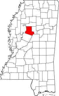 | |
| Unincorporated communities | ||