Casco, Wisconsin
| Casco, Wisconsin | |
|---|---|
| Village | |
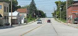 Looking west in Casco on WIS 54 | |
 Location of Casco, Wisconsin | |
| Coordinates: 44°32′16″N 87°35′35″W / 44.53778°N 87.59306°WCoordinates: 44°32′16″N 87°35′35″W / 44.53778°N 87.59306°W | |
| Country | United States |
| State | Wisconsin |
| County | Kewaunee |
| Area[1] | |
| • Total | 0.69 sq mi (1.79 km2) |
| • Land | 0.68 sq mi (1.76 km2) |
| • Water | 0.01 sq mi (0.03 km2) |
| Elevation[2] | 728 ft (222 m) |
| Population (2010)[3] | |
| • Total | 583 |
| • Estimate (2012[4]) | 581 |
| • Density | 857.4/sq mi (331.0/km2) |
| Time zone | Central (CST) (UTC-6) |
| • Summer (DST) | CDT (UTC-5) |
| Area code(s) | 920 |
| FIPS code | 55-12875[5] |
| GNIS feature ID | 1582922[2] |
| Website |
www |
Casco is a village in Kewaunee County, Wisconsin, United States. The population was 583 at the 2010 census. It is part of the Green Bay Metropolitan Statistical Area. The village is located within the Town of Casco.
Geography
Casco is located at 44°33′15″N 87°37′14″W / 44.55417°N 87.62056°W (44.554174, -87.620741).[6]
According to the United States Census Bureau, the village has a total area of 0.69 square miles (1.79 km2), of which, 0.68 square miles (1.76 km2) of it is land and 0.01 square miles (0.03 km2) is water.[1]
Demographics
| Historical population | |||
|---|---|---|---|
| Census | Pop. | %± | |
| 1930 | 246 | — | |
| 1940 | 292 | 18.7% | |
| 1950 | 389 | 33.2% | |
| 1960 | 460 | 18.3% | |
| 1970 | 481 | 4.6% | |
| 1980 | 484 | 0.6% | |
| 1990 | 544 | 12.4% | |
| 2000 | 572 | 5.1% | |
| 2010 | 583 | 1.9% | |
| Est. 2015 | 578 | [7] | −0.9% |
2010 census
As of the census[3] of 2010, there were 583 people, 230 households, and 155 families residing in the village. The population density was 857.4 inhabitants per square mile (331.0/km2). There were 247 housing units at an average density of 363.2 per square mile (140.2/km2). The racial makeup of the village was 91.1% White, 1.0% African American, 2.4% Native American, 3.8% from other races, and 1.7% from two or more races. Hispanic or Latino of any race were 7.5% of the population.
There were 230 households of which 37.0% had children under the age of 18 living with them, 53.5% were married couples living together, 11.3% had a female householder with no husband present, 2.6% had a male householder with no wife present, and 32.6% were non-families. 28.3% of all households were made up of individuals and 17.4% had someone living alone who was 65 years of age or older. The average household size was 2.53 and the average family size was 3.15.
The median age in the village was 35.6 years. 29.7% of residents were under the age of 18; 4.8% were between the ages of 18 and 24; 27.7% were from 25 to 44; 21.6% were from 45 to 64; and 16.3% were 65 years of age or older. The gender makeup of the village was 47.5% male and 52.5% female.
2000 census
As of the census[5] of 2000, there were 572 people, 227 households, and 162 families residing in the village. The population density was 1,022.1 people per square mile (394.4/km²). There were 236 housing units at an average density of 421.7 per square mile (162.7/km²). The racial makeup of the village was 97.55% White, 0.70% Native American, 0.87% from other races, and 0.87% from two or more races. 0.87% of the population were Hispanic or Latino of any race.
There were 227 households out of which 34.8% had children under the age of 18 living with them, 60.4% were married couples living together, 7.0% had a female householder with no husband present, and 28.2% were non-families. 25.1% of all households were made up of individuals and 12.8% had someone living alone who was 65 years of age or older. The average household size was 2.52 and the average family size was 3.01.
In the village the population was spread out with 27.1% under the age of 18, 7.2% from 18 to 24, 30.6% from 25 to 44, 18.7% from 45 to 64, and 16.4% who were 65 years of age or older. The median age was 36 years. For every 100 females there were 93.9 males. For every 100 females age 18 and over, there were 91.3 males.
The median income for a household in the village was $44,583, and the median income for a family was $50,000. Males had a median income of $36,029 versus $24,444 for females. The per capita income for the village was $18,168. About 2.8% of families and 4.0% of the population were below the poverty line, including 1.9% of those under age 18 and 9.6% of those age 65 or over.
Gallery
 Luxemburg-Casco High School
 Post office
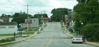 Downtown Casco
References
- 1 2 "US Gazetteer files 2010". United States Census Bureau. Archived from the original on 2012-07-14. Retrieved 2012-11-18.
- 1 2 "US Board on Geographic Names". United States Geological Survey. 2007-10-25. Retrieved 2008-01-31.
- 1 2 "American FactFinder". United States Census Bureau. Retrieved 2012-11-18.
- ↑ "Population Estimates". United States Census Bureau. Archived from the original on 2013-06-17. Retrieved 2013-06-24.
- 1 2 "American FactFinder". United States Census Bureau. Archived from the original on 2013-09-11. Retrieved 2008-01-31.
- ↑ "US Gazetteer files: 2010, 2000, and 1990". United States Census Bureau. 2011-02-12. Retrieved 2011-04-23.
- ↑ "Annual Estimates of the Resident Population for Incorporated Places: April 1, 2010 to July 1, 2015". Retrieved July 2, 2016.
- ↑ "Census of Population and Housing". Census.gov. Archived from the original on April 22, 2013. Retrieved June 4, 2015.
External links
| Wikimedia Commons has media related to Casco, Wisconsin. |
Municipalities and communities of Kewaunee County, Wisconsin, United States | ||
|---|---|---|
| Cities | 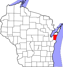 | |
| Villages | ||
| Towns | ||
| CDP | ||
| Unincorporated communities | ||
| Footnotes | ‡This populated place also has portions in an adjacent county or counties | |