Castlelost (civil parish)
| Castlelost Caisleán Loiste | |
|---|---|
| Civil parish | |
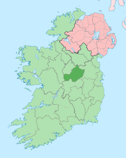
 Castlelost Location of Castlelost within County Westmeath in the Republic of Ireland | |
| Coordinates: 53°24′49″N 7°17′39″W / 53.41361°N 7.29417°WCoordinates: 53°24′49″N 7°17′39″W / 53.41361°N 7.29417°W | |
| Country |
|
| Province | Leinster |
| County | County Westmeath |
| Irish grid reference | N469405 |
Castlelost (Irish: Caisleán Loiste)[1] is a civil parish in County Westmeath, Ireland. It is located about 12.81 kilometres (8 mi) south of Mullingar.
Castlelost is one of 10 civil parishes in the barony of Fartullagh in the Province of Leinster. The civil parish covers 9,444.4 acres (38.220 km2).
Castlelost civil parish comprises the village of Rochfortbridge and 16 townlands: Castlelost, Castlelost West, Clontytallon, Collinstown and Kiltotan, Derry, Drumman, Farthingstown, Gallstown, Garrane, Gneevebane, Gortumly, Kilbrennan, Kiltotan and Collinstown, Oldtown, Piercetown, Rahanine and Rochfortbridge.
The neighbouring civil parishes are: Carrick, Kilbride and Pass of Kilbride to the north, Castlejordan (County Meath) to the east, Castlejordan (County Offaly), Croghan (County Offaly) and Newtown to the south and Clonfad to the West.[2][3]
References
- ↑ Castlelost civil parish Placenames Database of Ireland Retrieved on 12 July 2015.
- ↑ Castlelost civil parish, Co. Westmeath townlands.ie Retrieved on 12 July 2015.
- ↑ Castlelost civil parish, Co. Westmeath The IreAtlas Townland Data Base Retrieved on 12 July 2015.
External links
- Castlelost civil parish at the IreAtlas Townland Data Base
- Castlelost civil parish at townlands.ie
- Castlelost civil parish at the Placenames Database of Ireland