Cataract, Indiana
| Cataract, Indiana | |
|---|---|
| Unincorporated community | |
|
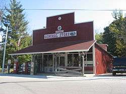
The community's general store | |
 Cataract, Indiana  Cataract, Indiana | |
| Coordinates: 39°25′39″N 86°48′59″W / 39.42750°N 86.81639°WCoordinates: 39°25′39″N 86°48′59″W / 39.42750°N 86.81639°W | |
| Country | United States |
| State | Indiana |
| County | Owen |
| Elevation | 771 ft (235 m) |
| Time zone | Eastern (EST) (UTC-5) |
| • Summer (DST) | EDT (UTC-4) |
| Area code(s) | 765 |
| GNIS feature ID | 432235[1] |
Cataract is an unincorporated community in Owen County, Indiana, United States. Cataract is 6 miles (9.7 km) south of Cloverdale.
History
Cataract was platted in 1851.[2] It takes its name from the large waterfalls, or cataract, nearby.[3] A post office was established at Cataract in 1846, and remained in operation until 1936.[4]
References
- ↑ U.S. Geological Survey Geographic Names Information System: Cataract, Indiana
- ↑ Blanchard, Charles (1884). Counties of Clay and Owen, Indiana: Historical and Biographical. F.A. Battey & Company. p. 811.
- ↑ Gannett, Henry (1905). The Origin of Certain Place Names in the United States. Govt. Print. Off. p. 72.
- ↑ "Owen County". Jim Forte Postal History. Retrieved 21 September 2015.
Municipalities and communities of Owen County, Indiana, United States | ||
|---|---|---|
| Towns | ||
| Townships | ||
| Unincorporated communities | ||
This article is issued from Wikipedia - version of the 9/30/2016. The text is available under the Creative Commons Attribution/Share Alike but additional terms may apply for the media files.