Chakrata
| Chakrata चक्राता | |
|---|---|
| Town | |
| चकराता | |
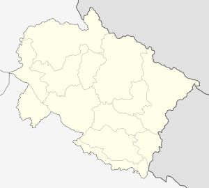 Chakrata  Chakrata Location in Uttarakhand, India | |
| Coordinates: 30°42′07″N 77°52′08″E / 30.702°N 77.869°ECoordinates: 30°42′07″N 77°52′08″E / 30.702°N 77.869°E | |
| Country |
|
| State | Uttarakhand |
| District | Dehradun |
| Elevation | 2,118 m (6,949 ft) |
| Population (2001) | |
| • Total | 3,498 |
| Languages | |
| • Official | {{{demographics1_info1}}} |
| • Native | {{{demographics1_info2}}} |
| Time zone | IST (UTC+5:30) |
| Vehicle registration | UK |
| Website |
uk |
Chakrata is a cantonment town in Dehradun district[1] in the state of Uttarakhand, India.
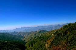
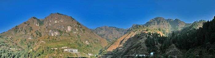
It is situated between the Tons and Yamuna rivers, at an elevation of 7000–7250 feet, 98 km from state capital, Dehradun, it was originally a cantonment of British Indian Army. Due west lies Himachal Pradesh, and due east are Mussoorie (73 km), Garhwal.
History
The area is known as Jaunsar-Bawar,[2] which still has a marked presence in few surrounding villages.
A cantonment of British Indian Army, was established in 1866 by Colonel Hume of the 55th Regiment, British Indian Army,[3] and the troops and officers first occupied the cantonment in April 1869.[1]
In 1901, Chakrata Tahsil was part of the Dehradun district, of United Provinces, with a collective population of 51,101, which consisted of the towns of Chakrata (population 1250) and Kalsi, with a population of 760,[2] which is most known for the rock edict of the Mauryan king Ashoka 2nd century BC, first discovered by John Forest, in 1860.[4]
Key Attraction
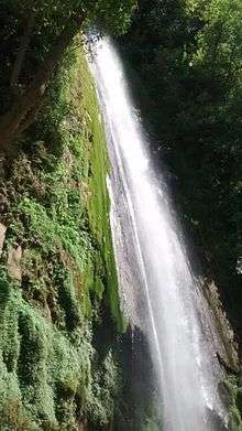
Chakrata has the highest direct waterfall in the Country. Tiger falls are 20 km from Chakrata and present at an elevation of 312 ft.
The cantonment
Chakrata is an access-restricted military cantonment, and foreigners face severe restrictions in visiting. Notably, it is the permanent garrison of the secretive and elite Special Frontier Force, also known as Establishment 22 ( called "Two-Two"), the only ethnic Tibetan unit of the Indian Army, which was raised after the Indo-China War of 1962. Various kinds of weapons and survival training is also imparted by other intelligence services in Chakrata, in support of various Indian foreign policy goals, especially pertaining to other countries in the Indian Subcontinent.
Chakrata can be reached from Dehradun via Mussoorie or Vikasnagar. Both routes pass through beautiful mountainous road. Traveling in the monsoon can be quite tricky as the area sees frequent road blockages due to landslides.
The area has an abundance of conifers, rhododendrons and oaks. The red rhododendrons are the most abundantly found in this region. The key attractions near Chakrata are: 1. Tiger fall, one of the highest direct water fall in Uttarakhand. 2. Budher (Moila Danda), is a picturesque meadow located at an altitude of 2800 metres. The Karst landscapes of Budher are home to a network of ancient limestone caves. 3. Kanasar is surrounded by one of the best rated Deodar forest of Asia. 4. Chirmiri sunset point located at 4 km from main Chakrata market is a picturesque plateau offering one of the best view of sunset. 5. Devban perched at about 2900 metres offer panoramic view of Himalayas. 6. Mundali meadows are hard to access yet hold a huge potential for winter sports.
The region also has a number of temples including ones at Hanol village near tiuni, Mahasu Devta Temple dedicated to Lord Mahasu (Though this is still a topic of discussion that Lord Mahasu is Lord Mahashiva or Lord Ramchnadra), Radina, Thaina, Indroli, Lakhwar, and Lakhamandal (on the banks of river Yamuna, known for its ancient Shiva Temple) which traces its existence to the legends of Mahabharata, the village also has several natural caves.[5][6]
The alpine meadows of Mundali (2776 mts.), offers skiing opportunities, November to April.
There are approx. 2-3 basic private hotels in Chakrata, and some dhabas. Petrol and diesel are hard to come by (for civilians), but can be obtained in small quantities from local traders. The famous hotels of chakrata are Blue Canvas Resort, Hotel Burans, Hotel Himalayan Paradise and Hotel Snow View(estd 1936).
Demographics
As of 2001 India census,[7] Chakrata had a population of 3497.[6] Males constitute 62% of the population and females 38%. Chakrata has an average literacy rate of 75%, higher than the national average of 59.5%; w with male literacy of 81% and female literacy of 65%. 12% of the population is under 6 years of age.
References
- 1 2
 Chisholm, Hugh, ed. (1911). "Chakrata". Encyclopædia Britannica. 5 (11th ed.). Cambridge University Press. p. 802..
 - 1 2 Chakrata Tahsil & Town The Imperial Gazetteer of India, 1909, v. 10, p. 125.
- ↑ Chakrata Official website of Dehradun city.
- ↑ Kalsi Official website of Dehradun city.
- ↑ Lakhamandal temple Official website of Dehradun city.
- 1 2 Excursions from Chakrata Garhwal Tourism.
- ↑ "Census of India 2001: Data from the 2001 Census, including cities, villages and towns (Provisional)". Census Commission of India. Archived from the original on 16 June 2004. Retrieved 1 November 2008.
External links
- Chakrata Tahsil & Town, The Imperial Gazetteer of India, v. 10, p. 125., 1909
- Chakrata Tourism
- Chakrata on wikimapia
- [1] Chakrata Travel Guide