Chandler, Texas
| Chandler, Texas | |
|---|---|
| City | |
|
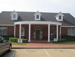
Chandler Library | |
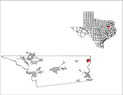
 Location of Chandler, Texas | |
 | |
| Coordinates: 32°18′26″N 95°28′46″W / 32.30722°N 95.47944°WCoordinates: 32°18′26″N 95°28′46″W / 32.30722°N 95.47944°W | |
| Country | United States |
| State | Texas |
| County | Henderson |
| Government | |
| • Type | General Law |
| • Mayor | Libby Fulgham |
| Area | |
| • Total | 3.6 sq mi (9.2 km2) |
| • Land | 3.5 sq mi (9.1 km2) |
| • Water | 0.0 sq mi (0.1 km2) |
| Elevation | 404 ft (123 m) |
| Population (2010) | |
| • Total | 2,734 |
| • Density | 781.1/sq mi (300.4/km2) |
| Time zone | Central (CST) (UTC-6) |
| • Summer (DST) | CDT (UTC-5) |
| ZIP code | 75758 |
| Area code(s) | 903 |
| FIPS code | 48-14224[1] |
| GNIS feature ID | 1332643[2] |
Chandler is a city in Henderson County, Texas, United States at the northern end of Lake Palestine. The population was 2,734 at the 2010 census.
Geography
Chandler is located at 32°18′26″N 95°28′46″W / 32.30722°N 95.47944°W (32.307206, -95.479340).[3]
According to the United States Census Bureau, the city has a total area of 3.5 square miles (9.1 km2), of which, 3.5 square miles (9.1 km2) of it is land and 0.1 square miles (0.26 km2) of it (1.41%) is water.
Demographics
| Historical population | |||
|---|---|---|---|
| Census | Pop. | %± | |
| 1970 | 765 | — | |
| 1980 | 1,308 | 71.0% | |
| 1990 | 1,630 | 24.6% | |
| 2000 | 2,099 | 28.8% | |
| 2010 | 2,734 | 30.3% | |
| Est. 2015 | 2,949 | [4] | 7.9% |

As of the census[1] of 2000, there were 2,099 people, 817 households, and 588 families residing in the city. The population density was 598.9 people per square mile (231.6/km²). There were 877 housing units at an average density of 250.2 per square mile (96.7/km²). The racial makeup of the city was 84.18% White, 13.15% African American, 0.29% Native American, 0.76% Asian, 0.29% from other races, and 1.33% from two or more races. Hispanic or Latino of any race were 0.81% of the population.
There were 817 households out of which 31.7% had children under the age of 18 living with them, 56.9% were married couples living together, 12.4% had a female householder with no husband present, and 28.0% were non-families. 25.3% of all households were made up of individuals and 13.8% had someone living alone who was 65 years of age or older. The average household size was 2.47 and the average family size was 2.96.
In the city the population was spread out with 24.4% under the age of 18, 6.1% from 18 to 24, 28.2% from 25 to 44, 21.2% from 45 to 64, and 20.2% who were 65 years of age or older. The median age was 39 years. For every 100 females there were 84.1 males. For every 100 females age 18 and over, there were 78.9 males.
The median income for a household in the city was $38,641, and the median income for a family was $50,000. Males had a median income of $36,125 versus $26,615 for females. The per capita income for the city was $19,075. About 8.2% of families and 9.8% of the population were below the poverty line, including 9.7% of those under age 18 and 11.0% of those age 65 or over.
Public amenities

Winchester Park is located on the southern end of Chandler. It boasts 3 baseball fields, a playground, 2 pavilions, 2 concession areas, a lake and a walking trail.
Economy
An array of businesses can be found in Chandler. Some examples are Brookshire's Grocery store and San Pedro's Mexican restaurant.
Education
The City of Chandler is served by the Brownsboro Independent School District. There are two public school campuses located in Chandler: Chandler Elementary School and Chandler Intermediate School.
Notable former residents
- Ralph Yarborough, politician
Ronnie Jack Smiley
See also
| Wikinews has related news: Small Texas town hosts large baseball tournament |
References
- 1 2 "American FactFinder". United States Census Bureau. Archived from the original on 2013-09-11. Retrieved 2008-01-31.
- ↑ "US Board on Geographic Names". United States Geological Survey. 2007-10-25. Retrieved 2008-01-31.
- ↑ "US Gazetteer files: 2010, 2000, and 1990". United States Census Bureau. 2011-02-12. Retrieved 2011-04-23.
- ↑ "Annual Estimates of the Resident Population for Incorporated Places: April 1, 2010 to July 1, 2015". Retrieved July 2, 2016.
- ↑ "Census of Population and Housing". Census.gov. Archived from the original on May 11, 2015. Retrieved June 4, 2015.
Municipalities and communities of Henderson County, Texas, United States | ||
|---|---|---|
| Cities |  | |
| Towns | ||
| Unincorporated communities | ||
| Ghost towns | ||
| Footnotes | ‡This populated place also has portions in an adjacent county or counties | |