Chanthaburi Province
| Chanthaburi จันทบุรี | ||
|---|---|---|
| Province | ||
| ||
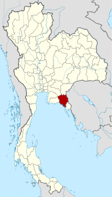 Map of Thailand highlighting Chanthaburi Province | ||
| Country |
| |
| Capital | Chanthaburi | |
| Government | ||
| • Governor | Witurat Srinam (since 2016) | |
| Area | ||
| • Total | 6,338 km2 (2,447 sq mi) | |
| Area rank | Ranked 34th | |
| Population (2014) | ||
| • Total | 527,350[1] | |
| • Rank | Ranked 52nd | |
| • Density rank | Ranked 56th | |
| Time zone | ICT | |
| ISO 3166 code | TH-22 | |

Chanthaburi (Thai: จันทบุรี; Chong: จันกะบูย, chankabui,[2] lit: "Lady Chan, Who wear a pan on her head"[3]) is a province (changwat) of Thailand. It is in the east of Thailand, on the border with Battambang and Pailin of Cambodia and on the shore of the Gulf of Thailand. Neighbouring provinces are Trat in the east and Rayong, Chonburi, Chachoengsao, and Sa Kaeo to the west and north.
History
After the Paknam crisis in 1893, French colonial troops occupied Chanthaburi, returning it in 1905 when Thailand gave up ownership of the western part of Cambodia. A significant minority of Chanthaburi citizens are native Vietnamese, who came there in three waves: first in the 19th century during anti-Catholic persecutions in Cochin China; a second wave in the 1920s to 1940s fleeing from French Indochina; and a third wave after the communist victory in Vietnam in 1975. The town of Chanthaburi has been the seat of a Bishop of Chanthaburi since 1944.
Geography

While the southern part of the province is on the shore of the Gulf of Thailand and thus is mostly coastal alluvial plains, the hinterlands of the province are quite mountainous. The Chanthaburi mountain range in the north has the highest elevation of the province, the 1,556 m high Soi Dao Nua Peak. The main river of the province is the Chanthaburi River.
Together with the neighboring province, Trat, Chanthaburi is a center of gemstone mining, especially rubies and sapphires. Tropical fruits are also among the main products of the province. In 2000, it produced nearly 380,000 tonnes of durian, which was 45.57% of Thailand's durian production, approximately 27% of the entire world's production.[4][5]
Within provincial boundaries lie three national parks: Namtok Phlio National Park;[6] Khao Khitchakut National Park;[7] and Khao Sip Ha Chan National Park.[8]
Symbols
The provincial seal shows the moon surrounded by an aura. Inside the moon disc is a rabbit, as in Thai folklore the dark areas on the moon (maria) form the shape of a rabbit. The seal symbolizes the peace and tranquility of the province. The moon also refers to the provincial name, "City of Moon".
The flag of the province also shows the seal in the middle, a white rabbit on a yellow moon disc, on a blue disc. The background of the flag is red, with the name of province in yellow written below the seal.
The provincial tree is Diospyros decandra. The provincial flower is an orchid.
The provincial slogan is Magnificent waterfalls, fruit city, good breeding peppercorns, loads of gems, Chanthabun mat, fertile nature, gathering place of King Taksin the Great's Liberation Army
Administrative divisions
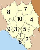
The province is subdivided in 10 districts (amphoe). These are further subdivided into 76 subdistricts (tambon) and 690 villages (muban).
References
- ↑ "Population of the Kingdom" (PDF). Department of Provincial Affairs (DOPA) Thailand (in Thai). 2014-12-31. Retrieved 19 Mar 2015.
- ↑ องค์ บรรจุน. สยามหลากเผ่าหลายพันธุ์. กรุงเทพฯ: มติชน, 2553, หน้า 128 (Thai)
- ↑ "ชอง จันทะบูย ฤาลมหายใจเฮือกสุดท้าย". OK Nation (in Thai). 19 October 2012. Retrieved 20 May 2016.
- ↑ http://www.foodmarketexchange.com/datacenter/product/fruit/durian/details/durain_02_grow.html
- ↑ http://www.foodmarketexchange.com/datacenter/product/fruit/durian/details/durain_07_production.htm
- ↑ "Namtok Phlio National Park". Department of National Parks (Thailand). Retrieved 25 September 2015.
- ↑ "Khao Khitchakut National Park". Department of National Parks (Thailand). Retrieved 25 September 2015.
- ↑ "Khao Sip Ha Chan National Park". Department of National Parks (Thailand). Retrieved 25 September 2015.
External links
 Chanthaburi travel guide from Wikivoyage
 |
Chachoengsao Province Chonburi Province |
Sa Kaew Province | Battambang Province, |
|
| Rayong Province | |
Pailin Province, | ||
| ||||
| | ||||
| Gulf of Thailand | Trat Province |
Coordinates: 12°36′37″N 102°06′10″E / 12.61028°N 102.10278°E