Charles B. Wheeler Downtown Airport
| Charles B. Wheeler Downtown Airport | |||||||||||||||
|---|---|---|---|---|---|---|---|---|---|---|---|---|---|---|---|
|
| |||||||||||||||
| IATA: MKC – ICAO: KMKC – FAA LID: MKC | |||||||||||||||
| Summary | |||||||||||||||
| Airport type | Public | ||||||||||||||
| Owner/Operator | Kansas City Aviation Department | ||||||||||||||
| Serves | Kansas City, Missouri | ||||||||||||||
| Elevation AMSL | 757 ft / 231 m | ||||||||||||||
| Coordinates | 39°07′23″N 094°35′34″W / 39.12306°N 94.59278°WCoordinates: 39°07′23″N 094°35′34″W / 39.12306°N 94.59278°W | ||||||||||||||
| Website | www.FlyMKC.com | ||||||||||||||
| Map | |||||||||||||||
 MKC Location of airport in Missouri | |||||||||||||||
| Runways | |||||||||||||||
| |||||||||||||||
| Statistics (2011) | |||||||||||||||
| |||||||||||||||
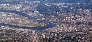
Charles B. Wheeler Downtown Airport (IATA: MKC[2], ICAO: KMKC, FAA LID: MKC) is a city owned, public use airport serving Kansas City, Missouri, United States.[1] Located in Clay County,[1] this facility is included in the National Plan of Integrated Airport Systems, which categorized it as a general aviation reliever airport.[3]
History
This airport replaced Richards Field as Kansas City's main airport. It was dedicated as New Richards Field in 1927 by Charles Lindbergh and was soon renamed Kansas City Municipal Airport. Its prominent tenant was Trans World Airlines (TWA) which was headquartered in Kansas City. The airport was built in the Missouri River bottoms next to the rail tracks at the Hannibal Bridge. At the time air travel was considered to be handled in conjunction with rail traffic.
The airport had limited area for expansion (Fairfax Airport across the Missouri River in Kansas City, Kansas covered a larger area). Airplanes had to avoid the 200-foot (60 m) Quality Hill and the Downtown Kansas City skyline south of the south end of the main runway. In the early 1960s an FAA memo called it "the most dangerous major airport in the country" and urged that no further federal funds be spent on it. Kansas City replaced the airport in 1972 with Kansas City International Airport.
The April 1957 Official Airline Guide (OAG) showed:
- Braniff International Airways - 40 weekday departures
- Trans World Airlines (TWA) - 39
- Continental Airlines - 9
- United Air Lines - 4
- Delta Air Lines - 2
- Ozark Airlines - 2
- Central Airlines - 2
The downtown airport has been renamed for Charles Wheeler who was mayor when Kansas City International opened. Richards Road which serves the airport is named for John Francisco Richards II, a Kansas City airman killed in World War I (and whose name was also applied to Richards Field and Richards-Gebaur Air Force Base).
Despite concerns about the airport being unsafe, Air Force One frequently uses it during Presidential visits.
Today the airport is used for corporate and recreational aviation. The terminal building today houses VML, a global advertising and marketing agency headquartered in Kansas City. Its location near downtown has excellent highway access.
It is home to the National Airline History Museum and the TWA Museum. Though the National Airline History Museum primarily contains artifacts from TWA (due to most of its volunteers are local retired TWA employees), the museum is dedicated to airline history in general. The TWA Museum is housed in the original Terminal that it was founded in at 10 Richards Road and is dedicated to the History of TWA. The airport also hosts the Aviation Expo (Air Show), most years, usually in August.
Facilities and aircraft
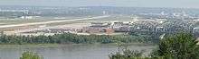
Charles B. Wheeler Downtown Airport covers an area of 700 acres (283 ha) at an elevation of 757 feet (231 m) above mean sea level.[1] It has two runways: 1/19 is 6,827 by 150 feet (2,081 x 46 m) with a concrete surface[1] with an EMAS at both ends.[4] 3/21 is 5,050 by 100 feet (1,539 x 30 m) with an asphalt surface.[1]
Construction on runway 1-19 is complete and both runways are in use to their full length.
Taxiway H was at one time part of runway 17/35. This runway was closed after an FAA decision on the amount of required separation between terminal buildings and the runway.
The airport is on the north side of the confluence of the Kansas River and Missouri River. Levees protected the airport relatively well during the Great Flood of 1951 and the Great Flood of 1993 although there was standing water. The 1951 flood devastated the Fairfax airport and caused Kansas City to build what would become Kansas City International Airport away from the river to keep the TWA overhaul base in the area after it had been destroyed in the flood at Fairfax.
Kansas City, MO Aviation Department announced plans on October 17, 2006 to build a $20 million aircraft hangar complex at the Charles B. Wheeler Downtown Airport including: 122 T-hangars, 13 box hangars, a 40,000-square-foot (4,000 m2) terminal building with offices, a pilots' lounge, meeting rooms and a destination restaurant.
For the 12-month period ending September 30, 2011, the airport had 67,793 aircraft operations, an average of 185 per day: 71.5% general aviation, 26% air taxi, 2.2% military, and 0.3% scheduled commercial. At that time there were 189 aircraft based at this airport: 47.6% single-engine, 28.6% multi-engine, 22.2% jet, and 1.6% helicopter.[1]
Cargo
| Airlines | Destinations |
|---|---|
| AirNet Express | Columbus-Rickenbacker |
Accidents and incidents
- On March 31, 1931, Notre Dame Coach Knute Rockne was killed on Transcontinental & Western Air Flight 599 from Kansas City to Los Angeles when the Fokker Trimotor broke up in a storm over Bazaar, Kansas. Rockne had been visiting his sons at Pembroke-Country Day School. The crash nearly put TWA out of business because it highlighted its aging fleet. The crash ushered in a golden era for TWA when it replaced the aging fleet with state-of-the-art aircraft.
- On January 16, 1942, Transcontinental & Western Air Flight 3 to Los Angeles impacted Mount Potosi in Nevada after a refueling stop in Las Vegas killing 22. Actress Carole Lombard was among the victims.
- On June 30, 1956, Trans World Airlines flight 2, a Lockheed Super Constellation, was bound for Kansas City Downtown Airport when it collided with a United Airlines Douglas DC-7 over the Grand Canyon. All 128 aboard both aircraft were killed.
- On May 22, 1962 Continental Airlines Flight 11 en route from Chicago O'Hare International Airport to Kansas City Downtown Airport exploded over Unionville, Missouri. All 45 on board were killed.
- On July 1, 1965, Continental Airlines Flight 12 from Los Angeles International Airport landed in heavy rain and was unable to stop due to hydroplaning. It impacted a blast mound and broke into 3 pieces but all 66 on board survived.
- On August 6, 1966, Braniff Airways Flight 250 left Kansas City Downtown Airport headed for Omaha and crashed near Falls City, Nebraska killing all 42 on board.
- On August 20, 2011, pilot Bryan Jensen was killed when his plane crashed during the Kansas City Air Expo.[5]
- On August 5, 2013, a construction contractor working on a taxiway near runway 1, discovered human remains buried in the ground.[6]
See also
References
- 1 2 3 4 5 6 7 FAA Airport Master Record for MKC (Form 5010 PDF). Federal Aviation Administration. Effective November 15, 2012.
- ↑ "Airline and Airport Code Search (MKC: Kansas City / Downtown)". International Air Transport Association (IATA). Retrieved March 14, 2014.
- ↑ "2011–2015 NPIAS Report, Appendix A" (PDF). faa.gov. Federal Aviation Administration. October 4, 2010. Archived from the original (PDF, 2.03 MB) on 2012-09-27.
- ↑ "Downtown airport boasts a new runway safety system". KansasCity.com. November 6, 2009.
- ↑ "Pilot Dies In KC Air Show". KMBC. August 20, 2011. Retrieved August 20, 2011.
- ↑ "Human remains found at KC downtown airport". KCTV. August 5, 2013.
External links
- Charles B. Wheeler Downtown Airport, official site
- Aerial image as of February 2002 from USGS The National Map
- Airport diagram as of 1956
- FAA Airport Diagram (PDF), effective November 10, 2016
- FAA Terminal Procedures for MKC, effective November 10, 2016
- Resources for this airport:
- FAA airport information for MKC
- AirNav airport information for KMKC
- ASN accident history for MKC
- FlightAware airport information and live flight tracker
- NOAA/NWS latest weather observations
- SkyVector aeronautical chart, Terminal Procedures