Great Flood of 1951
In mid-July 1951, heavy rains led to a great rise of water in the Kansas River and other surrounding areas of the central United States. Flooding resulted in the Kansas, Neosho, Marais Des Cygnes, and Verdigris river basins. The damage in June and July 1951 exceeded $935 million in an area covering eastern Kansas and Missouri, which, adjusting for inflation, is nearly $8.52 billion in 2016.[1] The flood resulted in the loss of 17 lives and displaced 518,000 people.[2]
Flood

The 1951 flood in Kansas began in May with the flood of the Big Creek, (a tributary of the Smoky Hill River) in Hays after eleven inches of rain in two hours. The creek overflowed, flooding Hays (the location of Fort Hays State College) to a depth of four feet in most locations inhabited by the coeds on campus, necessitating a midnight flight from the barracks (by families of the G.I. Bill) and dorms to the Stadium's third floor, which was still dry. Dr. Charles F. Wiest, Emeritus Professor of Philosophy and Religion, and his seven-year-old daughter perished when their home caved in with the weight of the water while he was saving prized texts in his basement. All records at the college were ruined and no graduation was held on the appointed date of May 23. Graduates were mailed their diplomas a month later.
The flooding continued into June 1951 with heavy rains that month. The flooding reached its worst stages when between 8 and 16 inches fell on the region between July 9 and July 13. The flood levels reached their highest point since the Great Flood of 1844 and Flood of 1903. July 13 experienced the single greatest levels of flood and led to the greatest amount of destruction by flood experienced in the Midwest as of that date.
The actual flood-levels are not accurately known for the Kansas River, as the water crested above all official flood gauges. However, between Manhattan and Bonner Springs flood levels were between 4 and 6 feet (1.2 and 1.8 m) above all previous records. The Marais Des Cygnes River, Verdigris River, and Neosho River crested more than 9 feet (2.7 m) above previous records.
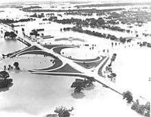
The heaviest initial damage by the flood crest was to Manhattan and Ft. Riley. Barracks at the Fort were destroyed, and in Manhattan the downtown business district was deluged under 8 feet (2.4 m) of water and two people were killed.[3] Following this, Topeka and Lawrence were also damaged by the same crest. Approximately 24,000 people were evacuated from Topeka.
The flood caused the Missouri River to change course at St. Joseph, Missouri cutting off the downtown area from Rosecrans Memorial Airport. In the aftermath the United States Army Corps of Engineers formalized the change by dredging its new channel. St. Joseph residents must now cross the Pony Express Bridge and go through Elwood, Kansas in order to reach the airport.
In Kansas City, the flood began running over the top of the levees protecting the Argentine and Armourdale areas, resulting in the evacuation of 15,000 people. Houses in Armourdale had water all the way to their roofs. The flood devastated the Kansas City Stockyards in the West Bottoms at the confluence of the Kansas and Missouri Rivers. The Stockyards would never fully recover. The flood destroyed the TWA overhaul base at Fairfax Airport in Kansas City, Kansas prompting the city of Kansas City, Missouri, to relocate TWA to a new airport in Platte County, Missouri that was to become Kansas City International Airport.
On July 13, a total of 1,074,000 acres (4346 km²) in Kansas and 926,000 acres (3750 km²) in Missouri were flooded.
The crest continued downstream passing through Boonville, Missouri on July 17, Jefferson City, Missouri on July 18, Hermann, Missouri on July 19, and St. Charles, Missouri on July 20 resulting in further flooding.
On July 17, President Harry Truman toured the damage by airplane, as far west as Manhattan, and declared the disaster "one of the worst this country has ever suffered from water."
Flood levels
Here are the measured river crest levels that the various rivers reached in the region affected.
Kansas River
| City | River crest | Height above flood stage | Date of measurement |
|---|---|---|---|
| Manhattan | 33.4 ft (10.2 m) | 15.4 ft (4.7 m) | July 13 |
| Wamego | 30.56 ft (9.31 m) | 11.6 ft (3.5 m) | July 13 |
| Topeka | 40.8 ft (12.4 m) | 14.8 ft (4.5 m) | July 13 |
| Lecompton | 30.23 ft (9.21 m) | 13.25 ft (4.04 m) | July 13 |
| Lawrence | 29.9 ft (9.1 m) | 11.9 ft (3.6 m) | July 13 |
| De Soto | 24.87 ft (7.58 m) | 09.41 ft (2.87 m) | July 13 |
Marais Des Cygnes River
| City | River crest | Height above flood stage | Date of measurement |
|---|---|---|---|
| Ottawa | 42.97 ft (13.10 m) | 11.97 ft (3.65 m) | July 11 |
Neosho River
| City | River crest | Height above flood stage | Date of measurement |
|---|---|---|---|
| Emporia | 33.4 ft (10.2 m) | 13.4 ft (4.1 m) | July 11 |
| Neosho Rapids | 34.3 ft (10.5 m) | 12.3 ft (3.7 m) | July 11 |
| Leroy | 34.48 ft (10.51 m) | 11.48 ft (3.50 m) | July 12 |
| Burlington | 41.53 ft (12.66 m) | 14.53 ft (4.43 m) | July 12 |
Outcome
Following this flood a series of levees and reservoirs were constructed throughout eastern Kansas. This new network of flood control structures helped to prevent widespread damage when the region was hit later by the Great Flood of 1993.
Prior to the flood there were five federal flood control dams in operation in the Kansas River basin:
- Bonny Dam in Colorado
- Enders Dam and Medicine Creek Dam in Nebraska
- Cedar Bluff Dam and Kanopolis Dam in Kansas
Several others had been planned by the United States Army Corps of Engineers and the Bureau of Reclamation, both authorized by the Flood Control Act of 1944.
Since then, many dams have been constructed so that a total of eighteen dams now control the flow of the Kansas River, such as Webster Dam and Kirwin Dam on tributaries of the Solomon River in Kansas. Many other reservoirs and levees were built in nearby in other basins were also built as part of a response to this flood, such as in the Osage River basin above the Lake of the Ozarks.
In North Lawrence there is a building shaped like a teepee. A mark on the side of the building indicates how high the water was around the building. The mark is about 7 feet up the side of the building.
In 2011 a painting of the flood "Flood Disaster" by Thomas Hart Benton sold for $1.9 million in an auction at Sotheby's in New York City. Benton had made the painting at the time of the flood and sent lithographs to every member of Congress to support a flood appropriations bill.[4][5]
Comparison to other big floods

Channeling and levee construction have altered how the floods have hit various areas along the Missouri River. Here is a comparison of the three big floods since the early 19th century.
- Great Flood of 1844 - This was the biggest flood of the three in terms of rate of discharge at Westport Landing in Kansas City. It is estimated that 625,000 cubic feet per second (17,700 m³/s) was discharged in the flood. However the crest, on July 16, 1844, was almost a foot lower than the 1993 flood.
- Great Flood of 1951 - The 1951 flood was the second biggest in terms of rate of discharge at 573,000 cubic feet per second (16,200 m³/s). The 1951 crest on July 14, 1951, was almost two feet (0.6 m) lower than the 1844 flood and three feet (1 m) lower than 1993. However, the flood was the most devastating of all modern floods for Kansas City since its levee system was not built to withstand it. It destroyed the city's stockyards and forced the building of an airport away from the Missouri River bottoms.
- Great Flood of 1993 - The 1993 flood was the highest of any of the three but had the lowest discharge at 541,000 ft³/s (15,300 m³/s). While the 1993 flood had devastating impacts elsewhere, Kansas City survived it relatively well because of levees improvements after the 1951 flood.
See also
References
- ↑ The Inflation Calculator. Retrieved on 2006-11-30.
- ↑ "1951 flood painting sells for nearly .9M in NYC". Fox News. May 19, 2011.
- ↑ Davis, Kenneth (1953). River on the Rampage. Doubleday.
- ↑ "1951 flood painting sells for nearly 1.9M in NYC". Fox News. May 19, 2011.
- ↑ 1951 Benton flood painting sells for $1.9 million (includes photo of painting)
External links
- NOAA Article on the 1951 Flood
- NOAA Report (PDF) on the 1951 flood with a comparison to the 1993 flood
- Access documents, photographs, and other primary sources on Kansas Memory, the Kansas State Historical Society's digital portal