Chatom, Alabama
| Chatom, Alabama | |
|---|---|
| Town | |
| Town of Chatom | |
|
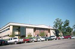
The Washington County Courthouse in September 2007 | |
 Location in Washington County and the state of Alabama | |
| Coordinates: 31°27′41″N 88°14′52″W / 31.46139°N 88.24778°WCoordinates: 31°27′41″N 88°14′52″W / 31.46139°N 88.24778°W | |
| Country | United States of America |
| State | Alabama |
| County | Washington |
| Area | |
| • Total | 10.9 sq mi (28.2 km2) |
| • Land | 10.9 sq mi (28.2 km2) |
| • Water | 0 sq mi (0 km2) |
| Elevation | 210 ft (64 m) |
| Population (2010) | |
| • Total | 1,288 |
| • Density | 109.4/sq mi (42.3/km2) |
| Time zone | Central (CST) (UTC-6) |
| • Summer (DST) | CDT (UTC-5) |
| ZIP code | 36518 |
| Area code(s) | 251 |
| FIPS code | 01-14008 |
| GNIS feature ID | 0115982 |
| Website | http://www.chatom.org/ |
Chatom is a town in Washington County, Alabama, United States. It incorporated in 1949.[1] Chatom is the county seat of Washington County, holding the distinction since 1907.[2] The town's population was 1,288 as of the 2010 United States Census, up from 1,193 in 2000.
Geography
Chatom is located at 31°27′42″N 88°14′53″W / 31.461656°N 88.248051°W.[3] According to the United States Census Bureau, the town has a total area of 10.9 square miles (28 km2), all land.
Demographics
| Historical population | |||
|---|---|---|---|
| Census | Pop. | %± | |
| 1950 | 609 | — | |
| 1960 | 993 | 63.1% | |
| 1970 | 1,059 | 6.6% | |
| 1980 | 1,122 | 5.9% | |
| 1990 | 1,094 | −2.5% | |
| 2000 | 1,193 | 9.0% | |
| 2010 | 1,288 | 8.0% | |
| Est. 2015 | 1,237 | [4] | −4.0% |
| U.S. Decennial Census[5] 2013 Estimate[6] | |||
As of the census[7] of 2000, there were 1,193 people, 449 households, and 308 families residing in the town. The population density was 109.7 people per square mile (42.3/km2). There were 523 housing units at an average density of 48.1 per square mile (18.6/km2). The ethnic makeup of the town was 67.23% White, 32.10% Black or African American, 0.42% Native American, 0.08% from other races, and 0.17% from two or more races. 0.50% of the population were Hispanic or Latino of any race.
There were 449 households out of which 38.1% had children under the age of 18 living with them, 48.6% were married couples living together, 18.0% had a female householder with no husband present, and 31.4% were non-families. 28.7% of all households were made up of individuals and 15.4% had someone living alone who was 65 years of age or older. The average household size was 2.48 and the average family size was 3.10.
In the town the population was spread out with 27.9% under the age of 18, 9.1% from 18 to 24, 23.9% from 25 to 44, 19.3% from 45 to 64, and 19.9% who were 65 years of age or older. The median age was 35 years. For every 100 females there were 83.8 males. For every 100 females age 18 and over, there were 73.4 males.
The median income for a household in the town was $31,319, and the median income for a family was $41,563. Males had a median income of $36,518 versus $19,750 for females. The per capita income for the town was $16,650. About 17.3% of families and 23.5% of the population were below the poverty line, including 34.4% of those under age 18 and 20.9% of those age 65 or over.
2010 census
As of the census[8] of 2010, there were 1,288 people, 458 households, and 326 families residing in the town. The population density was 118.2 people per square mile (45.7/km2). There were 521 housing units at an average density of 47.8 per square mile (18/km2). The ethnic makeup of the town was 68.2% White, 31.1% Black or African American, 0% Native American, 0.3% from other races, and 0.4% from two or more races. 0.6% of the population were Hispanic or Latino of any race.
There were 458 households out of which 33.8% had children under the age of 18 living with them, 46.9% were married couples living together, 20.7% had a female householder with no husband present, and 28.8% were non-families. 26.2% of all households were made up of individuals and 11.8% had someone living alone who was 65 years of age or older. The average household size was 2.49 and the average family size was 3.02.
In the town the population was spread out with 26.3% under the age of 18, 7.6% from 18 to 24, 23.9% from 25 to 44, 24.4% from 45 to 64, and 17.8% who were 65 years of age or older. The median age was 38.8 years. For every 100 females there were 90.3 males. For every 100 females age 18 and over, there were 95.7 males.
The median income for a household in the town was $23,250, and the median income for a family was $27,375. Males had a median income of $47,500 versus $28,235 for females. The per capita income for the town was $13,431. About 28.3% of families and 35.3% of the population were below the poverty line, including 56.3% of those under age 18 and 6.1% of those age 65 or over.
Climate
The climate in this area is characterized by hot, humid summers and generally mild to cool winters. According to the Köppen Climate Classification system, Chatom has a humid subtropical climate, abbreviated "Cfa" on climate maps. [9]
| Climate data for Chatom, Alabama | |||||||||||||
|---|---|---|---|---|---|---|---|---|---|---|---|---|---|
| Month | Jan | Feb | Mar | Apr | May | Jun | Jul | Aug | Sep | Oct | Nov | Dec | Year |
| Average high °C (°F) | 16 (60) |
18 (65) |
22 (72) |
26 (79) |
30 (86) |
33 (91) |
34 (93) |
33 (92) |
31 (88) |
27 (80) |
21 (70) |
17 (62) |
26 (78) |
| Average low °C (°F) | 2 (36) |
3 (38) |
7 (44) |
11 (52) |
16 (60) |
19 (66) |
21 (69) |
20 (68) |
18 (64) |
11 (52) |
6 (43) |
3 (37) |
11 (52) |
| Average precipitation mm (inches) | 140 (5.5) |
140 (5.5) |
157 (6.2) |
124 (4.9) |
130 (5) |
124 (4.9) |
160 (6.3) |
122 (4.8) |
117 (4.6) |
84 (3.3) |
109 (4.3) |
147 (5.8) |
1,552 (61.1) |
| Source: Weatherbase [10] | |||||||||||||
Notable natives
- Rusty Jackson, former NFL punter for the Los Angeles Rams and Buffalo Bills
- Shawna Thompson, member of country music duo Thompson Square
References
- ↑ http://www.encyclopediaofalabama.org/article/h-2546
- ↑ "Find a County". National Association of Counties. Archived from the original on 2011-05-31. Retrieved 2011-06-07.
- ↑ "US Gazetteer files: 2010, 2000, and 1990". United States Census Bureau. 2011-02-12. Retrieved 2011-04-23.
- ↑ "Annual Estimates of the Resident Population for Incorporated Places: April 1, 2010 to July 1, 2015". Retrieved July 2, 2016.
- ↑ "U.S. Decennial Census". Census.gov. Archived from the original on May 11, 2015. Retrieved June 6, 2013.
- ↑ "Annual Estimates of the Resident Population: April 1, 2010 to July 1, 2013". Retrieved June 3, 2014.
- ↑ "American FactFinder". United States Census Bureau. Archived from the original on 2013-09-11. Retrieved 2008-01-31.
- ↑ "American FactFinder". United States Census Bureau. Archived from the original on 2013-09-11. Retrieved 2015-08-14.
- ↑ Climate Summary for Chatom, Alabama
- ↑ "Weatherbase.com". Weatherbase. 2013. Retrieved on November 7, 2013.
Municipalities and communities of Washington County, Alabama, United States | ||
|---|---|---|
| Towns | 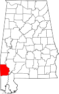 | |
| CDPs | ||
| Unincorporated communities | ||
| Ghost towns | ||
| Footnotes | ‡This populated place also has portions in an adjacent county or counties | |