Chauga Mound
 Location within Georgia today | |
| Location |
Westminster, South Carolina, Oconee County, South Carolina, |
|---|---|
| Region | Oconee County, South Carolina |
| Coordinates | 34°36′30.42″N 83°10′0.34″W / 34.6084500°N 83.1667611°W |
| History | |
| Founded | Middle Archaic |
| Abandoned | 18th century |
| Periods |
Jarett Phase (1100 to 1200) Tugalo Phase (1500 to 1600) |
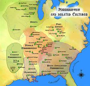
| Cultures | South Appalachian Mississippian culture |
| Site notes | |
| Excavation dates | 1953, 1958, 1959 |
| Archaeologists | Joseph R. Caldwell, Carl Miller, Arthur R. Kelly, Robert S. Neitzel |
| Architecture | |
| Architectural styles | platform mound, plaza |
| Architectural details | Number of temples: 1 |
The Chauga Mound (38OC1) is an archaeological site once located on the northern bank of the Tugaloo River 1,200 feet (370 m) north of the mouth of the Chauga River in Oconee County, South Carolina in the Lake Hartwell Basin. The mound is now inundated by Lake Hartwell. The mound and village portion of the site was built by peoples of the South Appalachian Mississippian culture (a regional variation of the Mississippian culture)[1]
Site description
The site is a mound and village that once sat on a natural levee about 100 feet (30 m) from the Tugaloo River at its confluence with the Chauga River.
Site chronology
There exist four distinct periods of occupation. The first period occurs during the Middle Archaic, as indicated by quartz and some scattered campsites. Phase two encompasses the first six levels of the mound and dates to the Jarett Phase (1100 to 1200), a local variation of the Etowah Culture. The third phase encompasses the final four stages of the mound construction and dates to the Tugalo Phase (1500 to 1600), a local manifestation of the Lamar Phase.
The final period of occupation dates from the Estatoe Phase to the early 18th century. It is associated with the historic Cherokee, an Iroquoian -speaking people who migrated into this area from the north.[2]
Mound

Originally standing about 12 feet (3.7 m) in height, the platform mound was constructed in 10 stages. Extensive damage through erosion and amateur digging have resulted in only the first four stages to have distinguishable form and purpose, while also decreasing the height of the mound to 8 feet (2.4 m). Stage 1 of the mound began as a low truncated rectangular pyramid about 2.2 feet (0.67 m) in height, which was probably used as a dance platform or dias. The fill for this mound came from the midden area of a previous Woodland period settlement; it was followed by a thinner semi-impermeable blue-grey clay cap. Stages 2–6 follow the same pattern. The clay cap had a low rim and trough around the base of the mound and in some cases extended to as much as 10 feet (3.0 m) from the base of the mound. The nature of the impervious clay and the trough to carry away rainwater helped to protect the interior basketloaded fill from erosion. At Stage 2 the mound was 45 feet (14 m) across at the base and with a summit roughly 25 feet (7.6 m) square and several feet higher than Stage 1. On top of this mound a structure was added. During these stages, smooth boulders from the river were incorporated into the mound, possibly to help stabilize the shape. Stages 7–10 did not have the clay cap feature and mound construction seems to occur only on the southern and eastern sides of the mound. These stages may have been to add an apron-like extension or ramp out from the main body of the mound.[3]
Burials
There are more than sixty burials at the Chauga site,[4] and more than thirty burials within the mound itself. The mound contains artifacts ranging from stone tools, potsherds and ornaments made of shells, copper plates,[5] rocks and minerals, many of which were deposited as grave goods with the burials.[3] Among the artifacts found at the site is a 30 millimetres (1.2 in) steatite plate with an anthropozoomorphic human-headed winged figure of a style often associated with the Southeastern Ceremonial Complex.[6]
Excavations
Joseph R. Caldwell first excavated there in 1953 and he was later followed by Carl Miller in 1958. The most complete excavation took place under the leadership of Arthur R. Kelly and Robert S. Neitzel from August, 1958 to January 1, 1959. Kelly and Nietzel performed salvage archaeology on the site in conjunction with the U.S. National Park Service while working at the University of Georgia with the hope of salvaging as much information as possible before the Hartwell Basin flooded the site.
See also
References
- ↑ "Southeastern Prehistory:Mississippian and Late Prehistoric Period". National Park Service. Archived from the original on 2008-06-07. Retrieved 2012-04-10.
- ↑ Hally, David J. (1998-08-01). "Chauga". In Gibbon, Guy; Kenneth M., Ames. Archaeology of Prehistoric Native America: An Encyclopedia. Routledge. pp. 143–144. ISBN 978-0815307259.
- 1 2 Kelly, Arthur R.; Neitzel, Robert S. (May 1961). "Chauga Mound and Village Site(38Oc1)in Oconee County, South Carolina" (PDF). University of Georgia Laboratory of Archaeology Series Report No. 3.
- ↑ Rodning, Christopher B. (2015). "Mortuary Patterns and Community History at the Chauga Mound and Village Site, Oconee County, South Carolina". Southeastern Archaeology. 34 (3): 171. Retrieved 20 October 2016.
- ↑ Roberts Thompson, Amanda D.; Williams, Mark (2015). "A Fresh Look at a Little-Known Southeastern Copper Plate". Southeastern Archaeology. 34 (2): 151. Retrieved 20 October 2016.
- ↑ Clemens de Baillou (October 1968). "Notes on Symbolism" (PDF). Southern Indian Studies. University of North Carolina. 20: 14.
External links
| Archaeological cultures |
|
|---|---|
| Archaeological sites |
|
| Human remains | |
| Miscellaneous |
|
| |