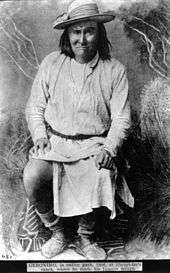
Chiricahua
 Location of Apache tribes in the late 18th century (Ch – Chiricahua, WA – Western Apache, M – Mescalero, J – Jicarilla, L – Lipan, Pl – Plains Apache | |
| Total population | |
|---|---|
| 650[1] | |
| Regions with significant populations | |
|
( | |
| Fort Sill | 712 |
| New Mexico | 149 |
| Languages | |
| English, Chiricahua Apache language | |
| Religion | |
| Christianity, Native American Church, traditional tribal religion | |
| Related ethnic groups | |
| Kiowa-Apache, Jicarilla Apache, Lipan Apache, Mescalero Apache, Western Apache, Navajo | |
Chiricahua (/ˌtʃɪrᵻˈkɑːwə/ US dict: chĭr′·ĭ·kâ′·wə) are a band of Apache Native Americans, based in the Southern Plains and Southwest United States. Culturally related to other Apache peoples, Chiricahua historically shared a common area, language, customs, and intertwined family relations. At the time of European contact, they had a territory of 15 million acres (61,000 km2) in Southwestern New Mexico and Southeastern Arizona in the United States and in Northern Sonora and Chihuahua in Mexico.
Today Chiricahua are enrolled in two federally recognized tribes in the United States: the Fort Sill Apache Tribe, located near Apache, Oklahoma with a reservation in Los Lunas, New Mexico,[2] and the Mescalero Apache Tribe of the Mescalero Reservation near Ruidoso, New Mexico. The San Carlos Apache Tribe, Arizona does have Chiricahua Apache people there also.
Name
The Chiricahua Apache were initially given their name by the Spanish. They are also known as the Chiricagui, Apaches de Chiricahui, Chiricahues, Chilicague, Chilecagez, and Chiricagua. The White Mountain Apache, including the Cibecue and Bylas groups of the Western Apache, called them Ha'i’ą́há and the San Carlos Apache called them Hák'ą́yé means ″'Eastern Sunrise, i.e. People in the East". Navajo call the Chiricahua Chíshí.
Their autonym for themselves is depending on the dialect simply Nde, Ne, Néndé, Héndé or Hen-de - ″The People, Men″, they never called themselves ″Apaches″; outsiders - Americans, Mexicans or other Indians - they called simply ⁿdáa or Indah / N'daa with two meaning: ″strange people, non-Apache people″ or ″Enemy″, but this can although be the word for ″eye″. Sometimes it is noted that all Apaches called the Americans and European settlers (with exception of the Mexicans) as Pindah-Lickoyee / Pinda-lick-o-yi ("White Eyes"), but this seems an appellation from Mescalero and Lipan Apache bands, the Chiricahua bands called the whites daadatlijende (″Blue/green eye people″) or 'Indaaɫigáí / Indaaɫigánde (″white skinned or pale colored people″ or literally ″strange, not Apache people, which are white skinned″). £igá' means "it is white" or it can be translated as "it is pale colored", the í on the end usually translates as "the one that is", but in the context of human beings, can mean "the group who are".
Please see the Bands section below for more names of bands and sub-bands of the Chihuahua (Central Apache).
Culture and organization
Several loosely affiliated bands of Apache came improperly to be usually known as the Chiricahuas. These included the Chokonen (recte: Tsokanende), the Chihenne (recte: Tchihende), the Nednai (Nednhi) and Bedonkohe (recte, both of them together: Ndendahe). Today, all are commonly referred to as Chiricahua, but they were not historically a single band nor the same Apache division, being more correctly identified, all together, as "Central Apaches".
Many other bands and groups of Apachean language-speakers ranged over eastern Arizona and the American Southwest. The bands that are grouped under the Chiricahua term today had much history together: they intermarried and lived alongside each other, and they also occasionally fought with each other. They formed short-term as well as longer alliances that have caused scholars to classify them as one people.[3]
The Apachean groups and the Navajo peoples were part of the Athabaskan migration into the North American continent from Asia, across the Bering Strait from Siberia. As the people moved south and east into North America, groups splintered off and became differentiated by language and culture over time. Some anthropologists believe that the Apache and the Navajo were pushed south and west into what is now New Mexico and Arizona by pressure from other Great Plains Indians, such as the Comanche and Kiowa. Among the last of such splits were those that resulted in the formation of the different Apachean bands whom the later Europeans encountered: the southwestern Apache groups and the Navajo. Although both speaking forms of Southern Athabaskan, the Navajo and Apache have become culturally distinct.
History
%2C_called_Dutchy_Chiricahua_scout_(F19052_DPLW).jpg)
The Tsokanende (Chiricahua) Apache division was once led, from the beginning of the 18th century, by chiefs such as Pisago Cabezon, Relles, Posito Moraga, Yrigollen, Tapilà, Teboca, Vivora, Miguel Narbona, Esquinaline, and finally Cochise (whose name was derived from the Apache word Cheis, meaning "having the quality of oak") and, after his death, his sons Tahzay and, later, Naiche, under the guardianship of Cochise's war chief and brother-in-law Nahilzay, and the independent chiefs Chihuahua, Ulzana, Skinya and Pionsenay; Tchihende (Mimbreño) people was led, during the same period, by chiefs as Juan Josè Compa, Fuerte a.k.a. Soldado Fiero, Mangas Coloradas, Cuchillo Negro, Delgadito, Ponce, Nana, Victorio, Loco, Mangus; Ndendahe Apache people, in the meanwhile, was led by Mahko and, after him, Mano Mocha, Coleto Amarillo, Luis, Laceres, Felipe, Natiza, and finally Juh and Goyaałé (known to the Americans as Geronimo). After Victorio's death, Nana, Geronimo, Mangus (youngest Mangas Coloradas' son) and youngest Cochise's son Naiche were the last leaders of the Central Apaches, and their mixed Apache group was the last to continue to resist U.S. government control of the American Southwest.[4]
European-Apache relations
From the beginning of EuropeanAmerican/Apache relations, there was conflict between them, as they competed for land and other resources, and had very different cultures. Their encounters were preceded by more than 100 years of Spanish colonial and Mexican incursions and settlement on the Apache lands.[5] The United States settlers were newcomers to the competition for land and resources in the Southwest, but they inherited its complex history, and brought their own attitudes with them about American Indians and how to use the land. By the Treaty of Guadalupe Hidalgo of 1848, the US took on the responsibility to prevent and punish cross-border incursions by Apache who were raiding in Mexico.[6]
The Apache viewed the United States colonists with ambivalence, and in some cases enlisted them as allies in the early years against the Mexicans. In 1852, the US and some of the Chiricahua signed a treaty, but it had little lasting effect.[7] During the 1850s, American miners and settlers began moving into Chiricahua territory, beginning encroachment that had been renewed in the migration to the Southwest of the previous two decades.
This forced the Apachean people to change their lives as nomads, free on the land. The US Army defeated them and forced them into the confinement of reservation life, on lands ill-suited for subsistence farming, which the US proffered as the model of civilization. Today, the Chiricahua are preserving their culture as much as possible, while forging new relationships with the peoples around them. The Chiricahua are a living and vibrant culture,[8] a part of the greater American whole and yet distinct based on their history and culture.
Hostilities
Although they had lived peaceably with most Americans in the New Mexico Territory up to about 1860,[9] the Chiricahua became increasingly hostile to American encroachment in the Southwest after a number of provocations had occurred between them.
In 1835, Mexico had placed a bounty on Apache scalps which further inflamed the situation. In 1837 Warm Springs Mimbreños' head chief and famed raider, Soldado Fiero a.k.a. Fuerte was killed by Mexican soldiers of the garrison at Janos (only two days' travel from Santa Rita del Cobre), and his son Cuchillo Negro succeeded him as head chief. In the same 1837, the American John (a.k.a. James) Johnson invited the Coppermine Mimbreños in the Pinos Altos area to trade with his party (near the mines at Santa Rita del Cobre, New Mexico and, when they gathered around a blanket on which pinole (a ground corn flour) had been placed for them, Johnson and his men opened fire on the Chihenne with rifles and a concealed cannon loaded with scrap iron, glass, and a length of chain. They killed about 20 Apache, including the chief Juan José Compá.[10] Mangas Coloradas is said to have witnessed this attack, which inflamed his and other Apache warriors' desires for vengeance for many years; he led the survivors to safety and subsequently, together with Cuchillo Negro, took Mimbreño revenge. The historian Rex W. Strickland argued that the Apache had come to the meeting with their own intentions of attacking Johnson's party, but were taken by surprise.[11] In 1839 scalp-hunter James Kirker was employed by Robert McKnight to re-open the road to Santa Rita del Cobre.
After the conclusion of the US/Mexican War (1848) and the Gadsden Purchase (1853), Americans began to enter the territory in greater numbers. This increased the opportunities for incidents and misunderstandings. Anyway, the Apaches, including Mangas Coloradas and Cuchillo Negro, were not at first hostile to the Americans, considering them enemies of their own Mexican enemies.
Cuchillo Negro, with Ponce, Delgadito, Victorio and other Mimbreño chiefs, signed a treaty at Fort Webster in April 1853, but, during the spring of 1857 the U.S. Army set out on a campaign, led by Col. Benjamin L.E. deBonneville, Col. Dixon S. Miles (3° Cavalry from Fort Thorn) and Col. William W. Loring (commanding a Mounted Rifles Regiment from Albuquerque), against Mogollon and Coyotero Apaches: Loring's Pueblo Indian scouts found out and attacked an Apache rancheria in the Canyon de Los Muertos Carneros (May 25, 1857), where Cuchillo Negro and some Mimbreño Apache were resting after a raid against the Navahos. Some Apaches, including Cuchillo Negro himself, were killed.
In December 1860, after several bad incidents provoked by the miners led by James H. Tevis in the Pinos Altos area, Mangas Coloradas went to Pinos Altos, New Mexico to try to convince the miners to move away from the area he loved and to go to the Sierra Madre and seek gold there, but they tied him to a tree and whipped him badly.[12] His Mimbreño and Ndendahe followers and related Chiricahua bands were incensed by the treatment of their respected chief. Mangas had been just as great a chief in his prime (during the 1830s and 1840s), along with Cuchillo Negro, as Cochise was then becoming.[13]
In 1861, the US Army seized and killed some of Cochise's relatives near Apache Pass, in what became known as the Bascom Affair. Remembering how Cochise had escaped, the Chiricahua called the incident "cut the tent."[14] In 1863, Gen. James H. Carleton set out leading a new campaign against the Mescalero Apache, and Capt. Edmund Shirland (10° California Cavalry) invited Mangas Coloradas for a "parley" but, after he entered the U.S. camp to negotiate a peace, the great Mimbreño chief was arrested and convicted in Fort McLane, where, probably after Gen. Joseph R. West's orders, Mangas Coloradas was killed by American soldiers (Jan. 18, 1863). His body was mutilated by the soldiers, and his people were enraged by his murder. The Chiricahuas began to consider the Americans as "enemies we go against them." From that time, they waged almost constant war against US settlers and the Army for the next 23 years. Cochise, his brother-in-law Nahilzay (war chief of Cochise's people), Chihuahua, Skinya, Pionsenay, Ulzana and other warring chiefs became a nightmare to settlers and military garrisons and patrols. In the meantime, the great Victorio, Delgadito (soon killed in 1864), Nana, Loco, young Mangus (last son of Mangas Coloradas) and other minor chiefs led on the warpath the Mimbreños, Chiricahuas' cousins and allies, and Juh led the Ndendahe (Nednhi and Bedonkohe together).
In 1872, General Oliver O. Howard, with the help of Thomas Jeffords, succeeded in negotiating a peace with Cochise. The US established a Chiricahua Apache Reservation with Jeffords as US Agent, near Fort Bowie, Arizona Territory. It remained open for about 4 years, during which the chief Cochise died (from natural causes).[15] In 1877, about three years after Cochise's death, the US moved the Chiricahua and some other Apache bands to the San Carlos Apache Indian Reservation, still in Arizona. The mountain people hated the desert environment of San Carlos, and some frequently began to leave the reservation and sometimes raid neighboring settlers. They surrendered to General Nelson Miles in 1886. The best-known warrior leader of the renegades, although he was not considered a 'chief', was the forceful and influential Geronimo. He and Naiche (the son of Cochise and hereditary leader after Tahzay's death) together led many of the resisters during those last few years of freedom.

They made a stronghold in the Chiricahua Mountains, part of which is now inside Chiricahua National Monument, and across the intervening Willcox Playa to the northeast, in the Dragoon Mountains (all in southeastern Arizona). In late frontier times, the Chiricahua ranged from San Carlos and the White Mountains of Arizona, to the adjacent mountains of southwestern New Mexico around what is now Silver City, and down into the mountain sanctuaries of the Sierra Madre (of northern Mexico). There they often joined with their Nednai Apache kin.
General George Crook, then General Miles' troops, aided by Apache scouts from other groups, pursued the exiles until they gave up. Mexico and the United States had negotiated an agreement allowing their troops in pursuit of the Apache to continue into each other's territories.[16] This prevented the Chiricahua groups from using the border as an escape route, and as they could gain little time to rest and consider their next move, the fatigue, attrition and demoralization of the constant hunt led to their surrender.
The final 34 hold-outs, including Geronimo and Naiche, surrendered to units of General Miles' forces in September 1886. From Bowie Station, Arizona, they were entrained, along with most of the other remaining Chiricahua (as well as the Army's Apache scouts), and exiled to Fort Marion, Florida. At least two Apache warriors, Massai and Gray Lizard, escaped from their prison car and made their way back to San Carlos Arizona in a 1,200-mile (1,900 km) journey to their ancestral lands.
After a number of Chiricahua deaths at the Fort Marion prison near St. Augustine, Florida, the survivors were moved, first to Alabama, and later to Fort Sill, Oklahoma. Geronimo's surrender ended the Indian Wars in the United States.[17] However, another group of Chiricahua (a.k.a. the Nameless Ones or Bronco Apache) were not captured by U.S. forces and refused to surrender. They escaped over the border to Mexico, and settled in the remote Sierra Madre mountains. There they built hidden camps, raided homes for cattle and other food supplies, and engaged in periodic firefights with units of the Mexican Army and police. Most were eventually captured or killed by soldiers or by private ranchers armed and deputized by the Mexican government.[18]
Eventually, the surviving Chiricahua prisoners were moved to the Fort Sill military reservation in Oklahoma. In August 1912, by an act of the U.S. Congress, they were released from their prisoner of war status as they were thought to be no further threat. Although promised land at Fort Sill, they met resistance from local non-Apache. They were given the choice to remain at Fort Sill or to relocate to the Mescalero reservation near Ruidoso, New Mexico. Two-thirds of the group, 183 people, elected to go to New Mexico, while 78 remained in Oklahoma.[19] Their descendants still reside in these places. At the time, they were not permitted to return to Arizona because of hostility from the long wars. in 1912 many different Apache bands returned to San Carlos Apache lands after their release from Fort Sill Apache Reservation.
Bands
.jpg)


Since the "band" as a unit was much more important than "tribe" in Chiricahua culture, the Chiricahua had no name for themselves (autonym) as a people. The name Chiricahua is most likely the Spanish rendering of the Opata word Chihuicahui or Chiguicagui ('mountain of the wild turkey') for the Chiricahua Mountains, later corrupted into Chiricahui/Chiricahua. The Chiricahua tribal territory encompassed today's SE Arizona, SW New Mexico, NE Sonora and NW Chihuahua. The Chiricahua range extended to the east as far as the Rio Grande Valley in New Mexico and to the west as far as the San Pedro River Valley in Arizona, north of Magdalena just below present day Hwy I-40 corridor in New Mexico and with the town Ciudad Madera (276 km northwest of the state capital, Chihuahua, and 536 km southwest of Ciudad Juárez (formerly known as Paso del Norte) on the Mexico–United States border), as their southernmost range.[20]
According to Morris E. Opler (1941), the Chiricahuas consisted of three bands:
- Chíhéne or Chííhénee’ 'Red Paint People' (also known as the Eastern Chiricahua, Warm Springs Apache, Gileños, Ojo Caliente Apache, Coppermine Apache, Copper Mine, Mimbreños, Mimbres, Mogollones, Tcihende),
- Ch'úk'ánéń or Ch'uuk'anén (also known as the Central Chiricahua, Ch'ók'ánéń, Cochise Apache, Chiricahua proper, Chiricaguis, Tcokanene), or the Sunrise People;
- Ndé'indaaí or Nédnaa'í 'Enemy People'[21] known as the Southern Chiricahua, Chiricahua proper, Pinery Apache, Ne'na'i), or "those ahead at the end".
Schroeder (1947) lists five bands:
- Mogollon
- Copper Mine
- Mimbres
- Warm Spring
- Chiricahua proper
The Chiricahua-Warm Springs Fort Sill Apache tribe in Oklahoma say they have four bands in Fort Sill: (some of the Arizona Apaches did not return to San Carlos or Fort Apache, White Mountain Apache warrior Eyelash is buried in Fort Sill cememtry, Southern Tonto Apache Chief/Scout Hosay is buried in Fort Apache cememtery, Hosay has family in Fort Sill and San Carlos today)
- Chíhéne (recte Tchi-he-nde, also known as the Warm Springs and Coppermine Mimbreño bands, Chinde),
- Chukunen (recte Tsoka-ne-nde, also known as the Chiricahua band, Chokonende),
- Bidánku (recte Bedonkohe Ndendahe, also known as Bidanku, Bedonkohe (?), Bronco),
- Ndéndai (recte Nednhi Ndendahe, also known as Ndénai, Nednai).
Today they use the word Chidikáágu (derived from the Spanish word Chiricahua) to refer to the Chiricahua in general, and the word Indé, to refer to the Apache in general.
Other sources list these and additional bands (only the Chokonen and Chihuicahui local groups of the Chokonen band were considered by Chiricahua tribal members to be the real Chiricahua people):
- Chokonen, Chukunende or Tsokanende[22] (aka Ch’ók’ánéń, Tsoka-ne-nde, Tcokanene, Chu-ku-nde, Chukunen, Ch’úk’ánéń, Ch’uuk’anén - ‘Ridge of the Mountainside People’, proper or Central Chiricahua)[23]
- Chokonen local group (lived west of Safford, Arizona, along the upper reaches of the Gila River, along the San Francisco River in the north to the Mogollon Mountains in New Mexico in the east and the San Simon Valley to the southwest, northeastern local group - headed by Chief Chihuahua (Kla-esh) and his segundo (war chief) and brother Ulzana)
- Chihuicahui group (lived in SE Arizona in the Huachuca Mountains west of the San Pedro River, in the northwest along a line of today's Benson, Johnson, Willcox, and north along the San Simon River to east of SW New Mexico, controlled the southern Pinaleno, Winchester, Dos Cabezas, Chiricahua, Dragoon and Mule Mountains, southwestern local group - headed by Cochise and after him by his sons, therefore known as Cochise Apache)
- Cai-a-he-ne local group (′Sun Goes Down People, i.e. People of the West′, were the westernmost of all Chihuicahui, western local group)
- Tse-ga-ta-hen-de local group (′Rock Pocket People′, lived in the Chiricahua Mountains)
- Dzil-dun-as-le-n local group (′Rocks At Foot of Grass-Expanse′, lived in the Dragoon Mountains)
- Dzilmora local group (in SW New Mexico in the Alamo Hueco, Little Hatchet and in the Big Hatchet Mountains (which were known to the Apache as Dzilmora), southeastern local group)
- Animas local group (lived south of the Rio Gila, and west of the San Simon Valley in the Peloncillo Mountains (called by Apache Dziltilcil - "Black Mountain") along the Arizona-New Mexico border south to the Guadalupe Canyon and eastward in the Animas Valley and Animas Mountains in SW New Mexico, southern local group)
- local group (today no longer known by name) (lived in NE Sonora and adjacent Arizona, in Guadalupe Canyon, along the San Bernardino River, northwestern parts of the Sierra San Luis, in the Batepito Valley with the Sierra Pitaycachi, east of Fronteras, as their stronghold)
- local group (today no longer known by name) (lived east of Fronteras in der Sierra Pilares de Teras in Sonora)
- local group (today no longer known by name) (lived in the Sierra de los Ajos northeast of the Sonora River, along the Bavispe River towards Fronteras in the north)
- Bedonkohe, Bidánku or Bidankande (Bi-dan-ku - 'In Front of the End People', Bi-da-a-naka-enda or Bedonkohe Ndendahe - 'Standing in front of the enemy', lived in West New Mexico between the San Francisco River in the West and the Gila River to the southeast, lived in the Tularosa Mountains and in their stronghold, the Mogollon Mountains, therefore often called Mogollon Apaches, were also known - together with other Apache local groups living along the Gila River and in the Gila Mountains - as Gileños / Gila Apaches, Northeastern Chiricahua - Geronimo, a prominent leader and medicine man (but not a chief) belonged to this band)
- local group (today no longer known by name) (lived in the Mogollon Mountains)
- local group (today no longer known by name) (lived also in the Mogollon Mountains)
- local group (today no longer known by name) (lived in the Tularosa Mountains)
- Chihenne, Chihende or Tchihende (aka Chi-he-nde, Tci-he-nde, Chíhéne, Chííhénee’ - 'Red Painted People', their autonym could relate to the mineral red coloration of the copper-containing tribal area, often called Copper Mine, Ojo Caliente / Warm Springs, Mimbreños / Mimbres and Gileños / Gila Apaches, improperly Eastern Chiricahua)
- Warm Springs Apache (the vicinity of Ojo Caliente (Spanish for Hot Springs) was their favourite retreat and was known to the Apache as Tih-go-tel - ′four broad plains′)
- northern Warm Springs local group (lived in the northeast of the Bedonkohe in the Datil, Magdalena and Socorro Mountains, the Plains of San Agustin, and from today's Quemado east toward the Rio Grande, northern local group - headed by Victorio)[24]
- southern Warm Springs local group (Warm Springs proper, settled around Ojo Caliente near present-day Monticello[25] along the Cañada Alamosa, between the Cuchillo Negro Creek and the Animas Creek, controlled the San Mateo as well as the Black Range west of the Rio Grande to the Rio Gila, used the warm springs in the vicinity of Truth or Consequences—hence called Warm Springs or Ojo Caliente Apaches, southern local group - headed by Cuchillo Negro)
- Gileños / Gila Apache (often used as a collective name for different Apache groups living along the Gila River; sometimes for all Chiricahua local groups and sometimes for the Aravaipa / Arivaipa Apache and Pinaleño / Pinal Apache of the Western Apache)
- Ne-be-ke-yen-de local group (′Country of People′ or ′Earth They Own It People′, presumably a mixed Chihenne-Bedonkohe local group, lived southwest of the Gila River, centered around the Santa Lucia Springs in the Little Burro and Big Burro Mountains, controlled the Pinos Altos Mountains, Pyramid Mountains and the vicinity of Santa Rita del Cobre along the Mimbres River in the east, then called Gileños / Gila Apaches, after discovering profitable copper mines at Santa Rita del Cobre they were called Copper Mine Apaches, western local group - headed by Mangas Coloradas, an Bedonkohe by birth, and later by Loco)[26]
- Mimbreño / Mimbres local group (lived in southeast-central New Mexico, between the Mimbres River and the Rio Grande up in the Mimbres Mountains and the Cook's Range, hence called Mimbreño / Mimbres Apaches, eastern local group; often the name Mimbreños is used to identify the whole Chihenne people, sometimes it is just thought of simply as an aggregation of some families belonging to the Chihenne people around the Mimbres Agency established by temporary Indian agent James M. Smith in 1853)
- local group (today no longer known by name) (lived in southern New Mexico in the Pyramid Mountains and Florida Mountains (called by the Chihenne Dzilnokone—Long Hanging Mountain) moved to the Rio Grande in the east and south to the Mexican border, southern group)
- Warm Springs Apache (the vicinity of Ojo Caliente (Spanish for Hot Springs) was their favourite retreat and was known to the Apache as Tih-go-tel - ′four broad plains′)
- Nednhi, Nde’ndai or Ndendahe (aka Ndéndai, Nde-nda-i, Nédnaa’í, Ndé’indaaí, Ndé’indaande, Ndaandénde - 'Enemy People', 'People who make trouble', the Mexicans adopted it as Bronco Apaches - ′Wild, Untamed Apaches′, lived in Sierra Madre Occidental and deserts of NW Chihuahua, NO Sonora and SE Arizona, therefore often called Sierre Madre Apaches, Southern Chiricahua)[27]
- Nednhi / Ndendahe Apache (they were subdivided in three local groups)
- Janeros local group (aka real Nednhi, lived in NW Chihuahua and NE Sonora, south into the Sierra San Luis, Sierra del Tigre, Sierra de Carcay, Sierra de Boca Grande, west beyond the Aros River to Bavispe, east along the Janos River and Casas Grandes River toward the Lake Guzmán in the northern part of the Guzmán Basin, because they traded at the presidio of Janos they were called Janeros Apache, because they preferred living in the nearly inaccessibly Sierra Madre Occidental, their autonym for themselves was Dzilthdaklizhéndé - ′Blue Mountain People, i.e. People of the Sierra Madre′, northern local group - headed by Juh)and the Hakaye people were part of Sierra Madre Mountains of Sonora Mexico.
- Tu-ntsa-nde local group (′Big Water People, i.e. People along the Aros River′, their stronghold called Guaynopa was in the bend of the Papigochic River (Aros River) east of the border of Sonora in the vicinity of a mountain, which called the Apache Dzil-da-na-tal - ′Mountain Holding Head Up And Peering Out′, smallest local group)
- Haiahende local group (′People of the Rising Sun, i.e. People of the East′, lived in the Peloncillo Mountains, Animas Mountains and Florida Mountains in SE Arizona and in New Mexico Bootheel and south into the deserts and mountains of NE of Sonora and the Mexican Plateau in NW Chihuahua, eastern local group)
- Carrizaleños local group (lived exclusively in Chihuahua, between the presidios of Janos in the west and Carrizal and Lake Santa Maria in the east, south toward Corralitos, Casas Grandes and Agua Nuevas 60 miles (97 km) north of Chihuahua, controlled the southern part of the Guzmán Basin, and the mountains along the Casas Grandes, Santa Maria and Carmen River, likely called Tsebekinéndé—'Stone House People' or 'Rock House People', southeastern group)
- Pinaleños / Pinery local group (lived south of Bavispe, between the Bavispe River and Aros River in NE Sonora and NW Chihuahua, controlled the Sierra Huachinera, Sierra de los Alisos and Sierra Nacori Chico, the mountains had a large stock of Apache Pine forest—hence they were called Pinaleños / Pinery Apaches, southwestern local group).
- Nednhi / Ndendahe Apache (they were subdivided in three local groups)
The Chokonen, Chihenne, Nednhi, and Bedonkohe had probably up to three other groups, named respectively after their leaders or homelands. By the end of the 19th century, surviving Apache no longer identified these groups. They may have been wiped out (like the Pinaleño-Nednhi) or had joined more powerful groups. For instance, the remnant of the Carrizaleño-Nedhni camped together with their northern kin, the Janero-Nednhi.
The Carrizaleňo-Nednhi shared overlapping territory in the surroundings of Casas Grandes and Agua Nuevas with the Tsebekinéndé, a southern Mescalero band (which was often called Aguas Nuevas by the Spanish). The Spanish referred to the Apache band by the same name of Tsebekinéndé. These two different Apache bands were often confused with each other. (Similar confusion arose over distinguishing the Janeros-Nednhi of the Chiricahua (Dzilthdaklizhéndé) and the Dzithinahndé of the Mescalero.
Notable Chiricahua Apache people
- Mangas Coloradas, (in Apache: La-choy Ko-kun-noste - "Red Sleeve″, rendering of his Apache nickname as Kan-da-zis Tlishishen - "Red Shirt" or "Pink Shirt", also Dasoda-hae - "He Just Sits There", ca. 1793–1863), war chief of the Copper Mines local group of the Tchihende people and principal chief after Juan Josè Compà's death
- Cuchillo Negro, ("Black Knife", in Apache: Baishan - ″Knife″) (ca. 1796 – May 24, 1857), war chief of the southern Warm Springs local group of the Tchihende people and principal chief after Fuerte's death
- Cochise, (in Apache: Shi-ka-She or A-da-tli-chi - "having the quality of strength of an oak″, after the Whites called him Cochise, the Apache adopted it as K'uu-ch'ish or Cheis), (ca. 1805–1874), chief of the Chihuicahui local group of the Tsokanende people
- Delgadito, (“Little Thin”, “Skinny”, in Apache: Tudeevia or Dudeevia), (ca. 1810–1864), principal chief of the Copper Mine local group of the Tchihende people after Mangas Coloradas' death
- Loco, (″crazy″, ″mad″ or "'crazy' enough to trust the white men″) (ca. 1820–1905), principal chief of the Copper Mine local group of the Tchihende people after Delgadito's death
- Nahilzay (aka Ny-Ith-Shizeh), (ca. 1827–after 1882), war chief and brother-in-law of Cochise, principal supporter of Tahzay and, later, of Naiche, as principal chiefs of the Tsokanende people against Chihuahua, Skinya and Pionsenay; captured by the Mexicans near Casas Grandes in the summer 1882
- Chihuahua (aka Chewawa, by the Apache also known as Kla-esh or Tłá’í’ez - “To push something under something else with your foot”), (1ca. 825–1901), youngest brother of Ulzana, but chief of their band, fought under Cochise orders, but didn't recognize Cochise's sons' leadership
- Skinya, (aka Haske-ne-l-a - ″Angry, He Stares at It″, ca. 1825–1876), head captain and medicine man, eldest brother of Pionsenay, fought under Cochise orders, brother-in-law of Naiche, but didn't recognize Cochise's sons' leadership, was killed by Naiche
- Pionsenay, (ca. 1830–ca. 1878), youngest brother of Skinya, fought under Cochise orders, but didn't recognize Cochise's sons' leadership, was badly wounded by Tahzay and probably killed by the Mexicans near Janos
- Dahteste, was the sister of Ilth-goz-ay, the wife of Chihuahua, chief of the Chokonen local group, woman warrior and companion of the famous woman warrior Lozen
- Gouyen, (aka Góyą́ń - "the one who is wise" or "Wise Woman", ca. 1857–1903), woman from the Warm Springs group of Tchihende people noted for her heroism; with her son Kaywaykla and her second husband Ka-ya-ten-nae she escaped the Battle of Tres Castillos, her infant daughter was said to have been killed in the attack
- Geronimo, (aka Goyaałé - "one who yawns"), (1829–1909), warrior, medicine man of the Bedonkohe Ndendahe band
- Juh, (aka Ho, Whoa, and sometimes Who - "Long Neck", others said that he was called Ho / Whoa / Who because he stuttered and could hardly talk at all when he became excited, his son Daklugie said that his real name was Ya-Natch-Cln - ″See Far Ahead″ or "He-sees-ahead" because of Juh’s several Powers, including the gift of prophecy, because of his success in raiding he was also known as Tan-Dɨn-Bɨl-No-Jui - ″He Brings Many Things With Him″), (ca. 1825–1883), medicine man and chief of the Janero local group of Nednhi band, after Victorio's dead he became the last dominant war Ieader, had three sons: Delzhinne (aka Talline or El-ge-de) and Daklegon (both captured by Mexicans and never heard again) and Asa Daklugie
- Lozen, ("Dextrous Horse Thief", ca. 1840-1890), woman warrior and prophet of the Tchihende people, sister of Victorio and companion of the woman warrior Dahteste
- Massai, (ca. 1847–1906/1911), warrior of the Mimbres Tchihende band
- Naiche (aka Nache, Nachi, or Natchez - "meddlesome one" or "mischief maker"), (ca. 1857–1919), second son of Cochise, was the final hereditary chief of the Chihuicahui local group of the Tsokanende people
- Nana, ("Grandma" or "Lullaby", in Apache: Kas-tziden - “Broken Foot” or Haškɛnadɨltla - “Angry, He is Agitated”), (ca. 1810–1896), war chief of the Warm Springs Tchihende people under Cuchillo Negro leadership and principal lieutenant to Victorio after his rising
- Mangus (ca. 1835–1901), youngest son of Mangas Coloradas and chief of the Copper Mine Tchihende people
- Taza (aka Tazi; Tazhe; Tah-ze; Tahzi; Tahzay, ca. 1843–1876), son of Cochise and his successor as chief of the Chihuicahui local group of Tsokanende people
- Victorio, (Bidu-ya, Beduiat, "he who checks his horse", ca. 1825–1880), chief of the Warm Springs Tchihende (Mimbreño) people, principal chief of the Mimbreño Apache (1864–1880) and leader of Mescalero, Ndendahe and Chiricaha peoples
- Ulzana (aka Josanni, Jolsanie or Ozaní’ - ″Tanned buckskin″ or Bį-sópàn - ″Big Buckskin″) (ca. 1821 - 1909), war chief under his eldest brother Chihuahua of the Chokonen local group of Tsokanende people, leader of a very famous raid through New Mexico and Arizona in 1885
- Fun (1866–1892, Yiy-gholl, Yiy-joll, Yiy-zholl - ″Smoke Goes Out″, also known as Larry Fun), warrior and according to Apache custom considered "half-brother" of Perico and Geronimo
- Ka-ya-ten-nae (aka Ka-e-te-nay, Kaytennae, Kadhateni, Kaidine or Kieta - "Fights Without Arrows", "Cartridges All Gone", from: "Kay" or "Kah" (arrow) - "Yah Te" (to fight without) - "Nnè" (man or that man), war chief (segundo) of Nana, then chief of the Warm Springs Tchihende people, second husband of the heroic Gouyen and stepfather of Kaywaykla
- Tso-ay ("Peaches") Scout for general Crook
- Mildred Cleghorn, gained federal recognized and served as first tribal chairperson of the Fort Sill Apache Tribe, elected in 1976
- Bob Haozous, sculptor
- Allan Houser, sculptor, educator
- Robert Roche (b. 1947), executive director of the American Indian Education Center in Cleveland, Ohio, anti-mascot activist
See also
Chiricahua language in popular culture
- Blueberry (film)
- The Missing (film) Tommy Lee Jones and other cast members learned to speak Chiricahua for the film. A dialect of the Apache language, with only about 300 speakers worldwide.(we still speak the Chiricahua dialect on the San Carlos Apache Rez today this is and Apache views) [28] The movie was screened for Apache's living in the Mescalero reservation to rave reviews, who understood every word onscreen and inspired many students to take pride in learning their native language.[29]
References
- ↑ 2011 Oklahoma Indian Nations Pocket Pictorial Directory. Archived May 12, 2012, at the Wayback Machine. Oklahoma Indian Affairs Commission. 2011: 15. Retrieved 3 Jan 2012.
- ↑ "Fort Sill Apache Tribe Receives U.S. Reservation Proclamation Following a 125 Year Wait". Reuters. 23 November 2011. Retrieved 25 November 2015.
- ↑ Debo, pp. 9-13.
- ↑ Thrapp, p.366.
- ↑ Thrapp p.6-8
- ↑ Thrapp p. 7
- ↑ Thrapp p.19
- ↑ "Chiricahua Apache Indian Nation". Chiricahuaapache.org. Retrieved 2010-03-11.
- ↑ Debo p.42.
- ↑ Roberts: p.36.
- ↑ Strickland, Rex W. (Autumn 1976) "The Birth and Death of a Legend: The Johnson Massacre of 1837"], Arizona and the West, Vol. 18, No. 3. p.257-86.
- ↑ Roberts p.37
- ↑ Roberts p. 35
- ↑ Roberts p.21-29
- ↑ Thrapp p.168
- ↑ Roberts p.223-4.
- ↑ Thrapp p.366-7.
- ↑ Salopek, Paul, Mexicans Recall Last Apaches Living in Sierra Madre, Chicago Tribune, 7 September 1997
- ↑ Debo p.447-8
- ↑ "Fort Sill Apache Tribe – Tribal Territory". Fortsillapache-nsn.gov. Retrieved 2013-11-06.
- ↑ "Tribal History". Fortsillapache-nsn.gov. Retrieved 2012-07-16.
- ↑ three variants of Chiricahua band names are listed: First: i.e. Chokonen is now the common / usual form, Second: Chukunende is used by Fort Sill Apache Tribe of Oklahoma, Third: Tsokanende is another Transcription
- ↑ Edwin R. Sweeney: Cochise: Chiricahua Apache Chief, University of Oklahoma Press 1995, ISBN 978-0-8061-2606-7
- ↑ Kathleen P. Chamberlain, Victorio: Apache Warrior and Chief, Norman: University of Oklahoma Press, 2007. ISBN 978-0-8061-3843-5
- ↑ Monticello (originally named Cañada Alamosa, Spanish for "Cottonwood Canyon") was headquarters for the Southern Apache Agency before a post was established at nearby Ojo Caliente in 1874. About 500 Apaches lived at Cañada Alamosa in 1870. Cochise and his Chiricahuas visited the area in 1871. Most of the Apaches were gone by 1877. The Chiricahuas called it Kegotoi - "Dilapidated Houses".
- ↑ Edwin R. Sweeney. Mangas Coloradas: Chief of the Chiricahua Apaches, Norman: University of Oklahoma Press, 1998. ISBN 978-0-8061-3063-7
- ↑ William B. Griffen: Apaches at War and Peace: The Janos Presidio 1750-1858, University of Oklahoma Press 1998, ISBN 978-0-8061-3084-2
- ↑ "Not Dead Yet: Ten Best Modern Westerns - Page 2 of 11 - The Film Box". The Film Box. Retrieved 2015-11-15.
- ↑ "Apaches praise 'The Missing' for language accuracy | Peninsula Clarion". peninsulaclarion.com. Retrieved 2015-11-15.
Cited works
- Debo, Angie. (1976) Geronimo: The Man, His Time, His Place, Norman: University of Oklahoma Press. ISBN 0-8061-1828-8.
- Roberts, David. (1993) Once They Moved Like the Wind, New York: Simon & Schuster. ISBN 0-671-702211
- Thrapp, Dan L. (1988) The Conquest of Apacheria, Norman: University of Oklahoma Press. ISBN 0-8061-1286-7
Bibliography
- Castetter, Edward F. and Opler, Morris E. (1936). The ethnobiology of the Chiricahua and Mescalero Apache: The use of plants for foods, beverages and narcotics. Ethnobiological studies in the American Southwest, (Vol. 3); Biological series (Vol. 4, No. 5); Bulletin, University of New Mexico, whole, (No. 297). Albuquerque: University of New Mexico Press.
- Hoijer, Harry and Opler, Morris E. (1938). Chiricahua and Mescalero Apache texts. The University of Chicago publications in anthropology; Linguistic series. Chicago: University of Chicago Press. (Reprinted 1964 by Chicago: University of Chicago Press; in 1970 by Chicago: University of Chicago Press; & in 1980 under H. Hoijer by New York: AMS Press, ISBN 0-404-15783-1).
- Opler, Morris E. (1933). An analysis of Mescalero and Chiricahua Apache social organization in the light of their systems of relationship. Unpublished doctoral dissertation, University of Chicago.
- Opler, Morris E. (1935). The concept of supernatural power among the Chiricahua and Mescalero Apaches. American Anthropologist, 37 (1), 65–70.
- Opler, Morris E. (1936). The kinship systems of the Southern Athabaskan-speaking tribes. American Anthropologist, 38 (4), 620–633.
- Opler, Morris E. (1937). An outline of Chiricahua Apache social organization. In F. Egan (Ed.), Social anthropology of North American tribes (pp. 171–239). Chicago: University of Chicago Press.
- Opler, Morris E. (1938). A Chiricahua Apache's account of the Geronimo campaign of 1886. New Mexico Historical Review, 13 (4), 360–386.
- Opler, Morris E. (1941). An Apache life-way: The economic, social, and religious institutions of the Chiricahua Indians. Chicago: The University of Chicago Press. (Reprinted in 1962 by Chicago: University of Chicago Press; in 1965 by New York: Cooper Square Publishers; in 1965 by Chicago: University of Chicago Press; & in 1994 by Lincoln: University of Nebraska Press, ISBN 0-8032-8610-4).
- Opler, Morris E. (1942). The identity of the Apache Mansos. American Anthropologist, 44 (1), 725.
- Opler, Morris E. (1946). Chiricahua Apache material relating to sorcery. Primitive Man, 19 (3–4), 81–92.
- Opler, Morris E. (1946). Mountain spirits of the Chiricahua Apache. Masterkey, 20 (4), 125–131.
- Opler, Morris E. (1947). Notes on Chiricahua Apache culture, I: Supernatural power and the shaman. Primitive Man, 20 (1–2), 1–14.
- Opler, Morris E. (1983). Chiricahua Apache. In A. Ortiz (Ed.), Southwest (pp. 401–418). Handbook of North American Indians (Vol. 10). Washington, D.C.: Smithsonian Institution.
- Opler, Morris E.; & French, David H. (1941). Myths and tales of the Chiricahua Apache Indians. Memoirs of the American folk-lore society, (Vol. 37). New York: American Folk-lore Society. (Reprinted in 1969 by New York: Kraus Reprint Co.; in 1970 by New York; in 1976 by Millwood, NY: Kraus Reprint Co.; & in 1994 under M. E. Opler, Morris by Lincoln: University of Nebraska Press. ISBN 0-8032-8602-3).
- Opler, Morris E.; & Hoijer, Harry. (1940). The raid and war-path language of the Chiricahua Apache. American Anthropologist, 42 (4), 617–634.
- Schroeder, Albert H. (1974). A study of the Apache Indians: Parts IV and V. Apache Indians (No. 4), American Indian ethnohistory, Indians of the Southwest. New York: Garland.
- Seymour, Deni J. (2002) Conquest and Concealment: After the El Paso Phase on Fort Bliss. Conservation Division, Directorate of Environment, Fort Bliss. Lone Mountain Report 525/528. This document can be obtained by contacting [email protected].
- Seymour, Deni J. (2003) Protohistoric and Early Historic Temporal Resolution. Conservation Division, Directorate of Environment, Fort Bliss. Lone Mountain Report 560-003. This document can be obtained by contacting [email protected].
- Seymour, Deni J. (2003) The Cerro Rojo Complex: A Unique Indigenous Assemblage in the El Paso Area and Its Implications For The Early Apache. Proceedings of the XII Jornada Mogollon Conference in 2001. Geo-Marine, El Paso.
- Seymour, Deni J. (2004) A Ranchería in the Gran Apachería: Evidence of Intercultural Interaction at the Cerro Rojo Site. Plains Anthropologist 49(190):153-192.
- Seymour, Deni J. (2004) Before the Spanish Chronicles: Early Apache in the Southern Southwest, pp. 120 –142. In "Ancient and Historic Lifeways in North America’s Rocky Mountains." Proceedings of the 2003 Rocky Mountain Anthropological Conference, Estes Park, Colorado, edited by Robert H. Brunswig and William B. Butler. Department of Anthropology, University of Northern Colorado, Greeley.
- Seymour, Deni J. (2007) Sexually Based War Crimes or Structured Conflict Strategies: An Archaeological Example from the American Southwest. In Texas and Points West: Papers in Honor of John A. Hedrick and Carol P. Hedrick, edited by Regge N. Wiseman, Thomas C. O’Laughlin, and Cordelia T. Snow, pp. 117–134. Papers of the Archaeological Society of New Mexico No. 33. Archaeological Society of New Mexico, Albuquerque.
- Seymour, Deni J. (2007) Apache, Spanish, and Protohistoric Archaeology on Fort Bliss. Conservation Division, Directorate of Environment, Fort Bliss. Lone Mountain Report 560-005. With Tim Church
- Seymour, Deni J. (2007) An Archaeological Perspective on the Hohokam-Pima Continuum. Old Pueblo Archaeology Bulletin No. 51 (December 2007):1-7. (This discusses the early presence of Athapaskans.)
- Seymour, Deni J. (2008) Despoblado or Athapaskan Heartland: A Methodological Perspective on Ancestral Apache Landscape Use in the Safford Area. Chapter 5 in Crossroads of the Southwest: Culture, Ethnicity, and Migration in Arizona's Safford Basin, pp. 121–162, edited by David E. Purcell, Cambridge Scholars Press, New York.
- Seymour, Deni J. (2008) A Pledge of Peace: Evidence of the Cochise-Howard Treaty Campsite. Historical Archaeology 42(4):154-179. With George Robertson.
- Seymour, Deni J. (2008) Apache Plain and Other Plainwares on Apache Sites in the Southern Southwest. In "Serendipity: Papers in Honor of Frances Joan Mathien," edited by R.N. Wiseman, T.C O'Laughlin, C.T. Snow and C. Travis, pp 163–186. Papers of the Archaeological Society of New Mexico No. 34. Archaeological Society of New Mexico, Albuquerque.
- Seymour, Deni J. (2008) Surfing Behind The Wave: A Counterpoint Discussion Relating To “A Ranchería In the Gran Apachería.” Plains Anthropologist 53(206):241-262.
- Seymour, Deni J. (2008) Pre-Differentiation Athapaskans (Proto-Apache) in the 13th and 14th Century Southern Southwest. Chapter in edited volume under preparation. Also paper in the symposium: The Earliest Athapaskans in Southern Southwest: Implications for Migration, organized and chaired by Deni Seymour, Society for American Archaeology, Vancouver.
- Seymour, Deni J. (2009) Evaluating Eyewitness Accounts of Native Peoples along the Coronado Trail from the International Border to Cibola. New Mexico Historical Review 84(3):399-435.
- Seymour, Deni J. (2009) Distinctive Places, Suitable Spaces: Conceptualizing Mobile Group Occupational Duration and Landscape Use. International Journal of Historical Archaeology 13(3): 255-281.
- Seymour, Deni J. (2009) Nineteenth-Century Apache Wickiups: Historically Documented Models for Archaeological Signatures of the Dwellings of Mobile People. Antiquity 83(319):157-164.
- Seymour, Deni J. (2009) Comments On Genetic Data Relating to Athapaskan Migrations: Implications of the Malhi et al. Study for the Apache and Navajo. American Journal of Physical Anthropology 139(3):281-283.
- Seymour, Deni J. (2009) The Cerro Rojo Site (LA 37188) -- A Large Mountain-Top Ancestral Apache Site in Southern New Mexico. Digital History Project. New Mexico Office of the State Historian.
- Seymour, Deni J. (2010) Cycles of Renewal, Transportable Assets: Aspects of the Ancestral Apache Housing Landscape. Accepted at Plains Anthropologist.
- Seymour, Deni J. (2010) Contextual Incongruities, Statistical Outliers, and Anomalies: Targeting Inconspicuous Occupational Events. American Antiquity. (Winter, in press)
External links
| Wikimedia Commons has media related to Apaches. |
- Indian Nations Indian Territory Archives - Ft. Sill Apache
- Fort Sill Apache Tribal Chairman Jeff Housers Website
- Chiricahua and Mescalero Apache Texts
- Allan Houser, Chiricahua Apache artist
- List of some Chiricaua warriors, probably from Thrapp's Biography
| Contemporary peoples native to Arizona | |
|---|---|
| Prehistoric cultures in Arizona | |
See also: List of Indian reservations in Arizona | |