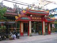
Cholon, Ho Chi Minh City
| Cholon, Ho Chi Minh City | |||||||||||||||
 Binh Tay Market in Cholon | |||||||||||||||
| Chinese name | |||||||||||||||
|---|---|---|---|---|---|---|---|---|---|---|---|---|---|---|---|
| Chinese | 堤岸[1][2] | ||||||||||||||
| Literal meaning | embankment | ||||||||||||||
| |||||||||||||||
| Vietnamese name | |||||||||||||||
| Vietnamese alphabet | Chợ Lớn | ||||||||||||||
| Hán-Nôm | 𢄂𡘯[3] | ||||||||||||||
Chợ Lớn (![]() listen) is a quarter of Ho Chi Minh City (formerly Saigon), in Vietnam. It lies on the west bank of the Saigon River, having Bình Tây Market as its central market. Cholon consists of the western half of District 5 as well as several adjoining neighborhoods in District 6. The quarter is long inhabited by Chinese people, and is considered the largest Chinatown in the world by area.
listen) is a quarter of Ho Chi Minh City (formerly Saigon), in Vietnam. It lies on the west bank of the Saigon River, having Bình Tây Market as its central market. Cholon consists of the western half of District 5 as well as several adjoining neighborhoods in District 6. The quarter is long inhabited by Chinese people, and is considered the largest Chinatown in the world by area.

The Vietnamese name Cholon literally means "big" (lớn) "market" (chợ). The Chinese name (and original name) of Cholon is 堤岸 (pronounced Tai-Ngon in Cantonese and Dī'àn in Mandarin,[1][2] which means "embankment" (French: quais). The Vietnamese reading of the Chinese name is Đê Ngạn, but this is rarely used. Vietnamese speakers exclusively use the name Chợ Lớn, while Chinese speakers (both inside Vietnam and in China) are the only users of the original Chinese name.
In 1778, the Hoa (Chinese minority of Vietnam) living in Biên Hòa had to take refuge in what is now Cholon because they were retaliated against by the Tây Sơn forces for their support of the Nguyễn lords. In 1782, they were again massacred by the Tây Sơn and had to rebuild. They built high embankments against the flows of the river, and called their new settlement Tai-Ngon (meaning "embankment" in Cantonese).
Cholon was incorporated as a city in 1879, 11 km from Saigon. By the 1930s, it had expanded to the city limit of Saigon. On 27 April 1931, Cholon and the neighbouring city Saïgon were merged to form a single city called ‘Saigon–Cholon’. The official name, however, never entered everyday vernacular and the city continued to be referred to as ‘Saigon’. ‘Cholon’ was dropped from the city's official name in 1956, after Vietnam gained independence from France in 1955.[4]
During the Vietnam War, soldiers and deserters from the United States Army maintained a thriving black market at Cholon, trading in various American and especially U.S Army-issue items. This was the area, near the Quan Âm Pagoda where photojournalist Eddie Adams took his famous execution photograph.[5] Four Australian journalists were also killed in Cholon during the Tet Offensive in 1968.[6]
Today, Cholon especially attracts many Mainland Chinese and Taiwanese tourists.
Notable residents
- Yvon Petra - He was born in Cholon. He is best remembered as the last Frenchman to win the Wimbledon championships men's singles title in 1946.
- Cao Văn Viên - Chief of the Joint General Staff of the Army of the Republic of Vietnam from 1966 to 1975.[7][8]
- Gontran de Poncins - French author, aristocrat and adventurer lived here in 1955. He resided in the Sun Wah hotel, keeping an illustrated journal which was published as From a Chinese City (published in 1957). "He chose Cholon, the Chinese riverbank community snuggled up to Saigon, because he suspected the ancient customs of a national culture endure longer in remote colonies than in the motherland. In effect, he was studying a bit of ancient China."[9]
- Charles Tran Van Lam
See also
| Wikimedia Commons has media related to Chinatown, Ho Chi Minh City. |
External links
 "Cholon". Encyclopædia Britannica. 6 (11th ed.). 1911. p. 267.
References
- 1 2
- 1 2
- ↑
- ↑ P. 61, Historic Dictionary of Ho Chi Minh City (written by Justin Corfield; published by Anthem Press in 2013)
- ↑ Faber, John (1978). Great News Photos and the Stories Behind Them. Courier Dover Publications. p. 136.
- ↑ Colebatch, Hal G.P (30 October 2009). "The Saigon media slaughter". The Australian. Retrieved 2013-11-06.
- ↑ St. George, Donna. "Cao Van Vien, 1921-2008." Washington Post. January 2, 2009.
- ↑ Kinnard, Douglas. The War Managers: American Generals Reflect on Vietnam. Reprint ed. Cambridge, Massachusetts: Da Capo Press, 1991. ISBN 0-306-80449-2
- ↑ Book product description.
Coordinates: 10°44′56″N 106°39′00″E / 10.749°N 106.65°E