Christies Beach, South Australia
| Christies Beach Adelaide, South Australia | |||||||||||||
|---|---|---|---|---|---|---|---|---|---|---|---|---|---|
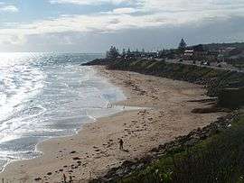 View of the Christies Beach coastline from Witton Bluff | |||||||||||||
 Christies Beach | |||||||||||||
| Coordinates | 35°08′06″S 138°28′37″E / 35.13494°S 138.476960°ECoordinates: 35°08′06″S 138°28′37″E / 35.13494°S 138.476960°E | ||||||||||||
| Population | 4,832 (2006 Census)[1] | ||||||||||||
| Established | 1925[2] | ||||||||||||
| Postcode(s) | 5165[3] | ||||||||||||
| Location | 26 km (16 mi) from Adelaide city centre | ||||||||||||
| LGA(s) | City of Onkaparinga | ||||||||||||
| State electorate(s) | Reynell[4] | ||||||||||||
| Federal Division(s) | Kingston[5] | ||||||||||||
| |||||||||||||
| |||||||||||||
| Footnotes |
Coordinates[2] Location[3] Climate[6] Adjoining suburbs[2] | ||||||||||||
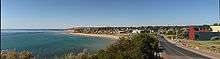
Christies Beach is a seaside suburb in the southern Adelaide metropolitan area, within the City of Onkaparinga. The area is scenic and hence popular with photographers as Witton Bluff provides a natural vantage point over the entire suburb and beyond.
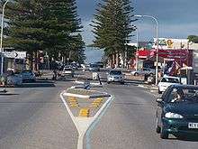
Christies Beach boasts a unique commercial strip running the entire length of Beach Road and is identified as a primary coastal node in the Adelaide Metropolitan area (Planning SA, 2007). Christies Beach also features one of the few remaining main road classified Esplanades in Metropolitan Adelaide, providing direct access to the beach on Gulf St Vincent.
Christies Beach has its own postcode of 5165, and is adjacent to the suburbs of Christie Downs and Noarlunga Centre to the east, Port Noarlunga to the south, and O'Sullivan Beach to the north.
Development
The very first development to occur along the coast of Christies Beach can be traced back to pre-colonization times, almost 40,000 years ago. The indigenous Kaurna people used the coastal area of Christies Beach (at the time known as Mullawirratingga) as a place for seasonal residence. They constructed structures known as a ‘Wodli’, which are small shelters made of branches and leaves. These structures were semi-permanent, only lasting the length of the summer period, after which they were then disassembled (City of Onkaparinga, 2005).
The first European development along the Christies Beach coastline was constructed in the 1830s. A whaling station was constructed along the coast, influenced by the rising price of whale bone overseas, the abundant Southern Right Whale population during the summer breeding season and the vantage point of Gulf St Vincent from Witton Bluff. By the 1840s the seasonal whale population dwindled down to unprofitable levels with the whales changing their migration route, and the whalers left the area to pursue other activities (Colwell, 1972) (Towler, 1986).
An area of surveyed land covering Glenelg to Witton Bluff (Christies Beach) known as District B, was made available for settlement in 1838. Many farmers took plots of land along the Anderson Creek (now known as Christies Creek). In 1895 Lambert Christie and his wife Rosa established a farm that covered the area where Christies Beach is now situated. The entire area remained a land of farming communities until 1923. This is when Rosa Christie created the first subdivision in the area, it was named Christie Beach. With this subdivision and other such residential allocations in the area road and rail transportation was improved. The improvement in transportation south of Adelaide gave Christies Beach an increase in tourists and holiday makers who were looking for a coastal experience. Many tourists decided to build cottages and holiday shacks on Witton Bluff and down onto the beach itself (City of Onkaparinga, 2005).
With the influx of visitors and new residents to the area the Christies Beach Progressive Association was formed to provide good foreshore amenities, such as beach access, toilets, showers, etc. Foreshore developments led to the creation of new shops and services on the Esplanade and nearby Gulfview and Beach Roads. By the late 1950s demand for residence in the area skyrocketed, this propelled commercial and industrial developments in the Lonsdale district with the opening of Port Stanvac Oil Refinery and Chrysler (later Mitsubishi) engine plant and also in Noarlunga with the relocation of the train line and the construction of Colonnades Shopping Centre (Colwell, 1972) (City of Onkaparinga, 2005).
Christie Beach Post Office opened on 3 April 1945 and was renamed Christies Beach around 1961. Christies Beach North office opened on 5 June 1962.[7]
Future Development
Existing foreshore developments include toilet facilities, benches, shelter, barbecue facilities, native vegetation plantations, fencing, informational signage, beach access stairs, & paved footpaths on both sides of the Esplanade. Recently all overhead power lines along the Esplanade have been converted to underground power lines to improve the scenic value of the foreshore. Future development plans for the Christies Beach foreshore established under the Metropolitan Coast Park Plan include the allocation of parking areas to remove on the side of the road parking, continued planting of native vegetation and the creation of more open recreation grass spaces, & converting the footpath into a multi-recreational path that can be used by walkers and cyclists alike and is connected to similar coastal paths along coasts further north and south, & changing the flow of traffic along the coast so as to turn it into a recreational road, rather than a thoroughfare.
Sport
The central sporting hub for the Christies Beach area is the John Bice Memorial Oval, home of the Christies Beach Football Club, Southern Districts Cricket Club and the Christies Beach Sports and Social Club.
Morrow Road Bridge
The Morrow Road bridge over Christies Creek, a Local Heritage place, was once the main road bridge linking Christies Beach to O'Sullivan Beach. The structure is thought to be the only remaining example of a wooden road bridge in the former Noarlunga Council area.[8]

Citations and references
- Citations
- ↑ Australian Bureau of Statistics (25 October 2007). "Christies Beach (State Suburb)". 2006 Census QuickStats. Retrieved 19 July 2010.
- 1 2 3 "Search result for "Christies Beach (SUB)" (Record no. SA0013925) with the following layers selected - "Suburbs and Localities" and " Place names (gazetteer)"". Property Location Browser. Government of South Australia. Retrieved 2 November 2016.
- 1 2 "Christies Beach, South Australia (Postcode)". postcodes-australia.com. Retrieved 13 November 2016.
- ↑ "District of Reynell Background Profile". ELECTORAL COMMISSION SA. 2014.
- ↑ "Map of the Federal division of Kingston" (PDF). Australian Electoral Commission. 2011. Retrieved 28 July 2015.
- ↑ "Monthly climate statistics: Summary statistics Noarlunga (nearest weather station)". Commonwealth of Australia , Bureau of Meteorology. Retrieved 11 October 2016.
- ↑ Premier Postal History. "Post Office List". Premier Postal Auctions. Retrieved 26 May 2011.
- ↑ "Heritage Places - Bridge across Christie Creek". City of Onkaparinga. City of Onkaparinga. Retrieved 12 April 2016.
- References
- Australian Bureau of Statistics. (2006). People occupying high or medium density housing - Christies Beach. Australian Census 2006.
- City of Noarlunga. (1997). Noarlunga Coastal Management Plan. Adelaide: Rust PPK Pty Ltd.
- City of Onkaparinga. (2004). Christies Beach Coastal Precinct. Adelaide: Rust PPK Pty Ltd.
- City of Onkaparinga. (1930). History of Christies Beach. Retrieved 23 August 2007, from Local Studies On-Line: http://www.onkaparingacity.com/libraries/localstudies/view_details.asp?RefID=1200
- Colwell, M. (1972). The History of the Noarlunga District. Adelaide: Scrymgour & Sons.
- Planning SA. (2001). Adelaide Metropolitan Coast Park Concept Plan. Adelaide: PPK Environment & Infrastructure Pty Ltd.
- Planning SA. (17 May 2007). Christies Beach. Retrieved 27 August 2007, from Planning SA: http://www.planning.sa.gov.au/go/open-space-and-urban-design/open-space-projects/metropolitan-open-space-system/coast-park/example-projects/christies-beach
- Planning SA. (2001). Precinct 3 - Mid South Coast. Adelaide: PPK Environment & Infrastructure Pty Ltd.
- Planning SA. (2001). Summary of Adelaide Metropolitan Coast Park Concept Plan. Adelaide: PPK Environment & Infrastructure Pty Ltd.
- Towler, D. (1986). A Fortunate Locality. Adelaide: Peacock Publications.
- Turner, A. (1994). Fingers crossed for a revival. The Advertiser, pg14.
| Wikimedia Commons has media related to Christies Beach, South Australia. |