Old Noarlunga, South Australia
| Old Noarlunga Adelaide, South Australia | |||||||||||||
|---|---|---|---|---|---|---|---|---|---|---|---|---|---|
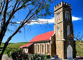 Old Noarlunga Church | |||||||||||||
 Old Noarlunga | |||||||||||||
| Coordinates | 35°10′57″S 138°30′05″E / 35.18248°S 138.501470°ECoordinates: 35°10′57″S 138°30′05″E / 35.18248°S 138.501470°E | ||||||||||||
| Population | 1,252 (2006 census)[1] | ||||||||||||
| Established | 1840 | ||||||||||||
| Postcode(s) | 5168[2] | ||||||||||||
| Location | 30 km (19 mi) from Adelaide | ||||||||||||
| LGA(s) | City of Onkaparinga | ||||||||||||
| |||||||||||||
| Footnotes |
Location[2] Coordinates[3] Adjoining suburbs[3] | ||||||||||||
Old Noarlunga (formerly Noarlunga) is a suburb in the Australian state of South Australia located about 30 kilometres (19 mi) south of the state capital of Adelaide. Originally settled around 1840, the town retains its village atmosphere in spite of encroaching suburbia. At the 2006 census, Old Noarlunga had a population of 1,252.[1]
History
In 1850 the South Australia Company laid out the 'No-orlunga Township' at the 'Horseshoe', Onkaparinga River. The name "No-orlunga" supposedly comes from the Kaurna word meaning 'fishing place'.[4]
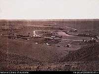
In the early years of settlement, the surrounding area was cleared for wheat farming, and a flour mill was built in the town in 1843 along with wharves used to transport produce down the Onkaparinga River to Port Noarlunga via barge. The town still has a stone bridge across the Onkaparinga, making the town a focal point for travel further down the coast. 1856 saw the formation of the District Council of Noarlunga.
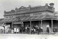
By the 1860s the town had a post office, a council chamber, two churches, a public pound, two hotels, a mill, a brewery and a brickworks.[4]
Old Noarlunga became a well known sporting venue, visited by cycling clubs and throughout the 20th century the town was a popular stopping point for tourists on the way to beaches in the region.[4]
1972 saw Main South Road bypass the town and in 1978, by council resolution it became Old Noarlunga. Many local residents at the time were not in favour of the townships name change.
See also
Notes
- 1 2 Australian Bureau of Statistics (25 October 2007). "Old Noarlunga (State Suburb)". 2006 Census QuickStats. Retrieved 17 October 2011.
- 1 2 "Old Noarlunga, South Australia (Postcode)". postcodes-australia.com. Retrieved 17 October 2016.
- 1 2 "Search result for " Old Noarlunga (LSUB)" (Record no SA0053556) with the following layers selected - "Suburbs and Localities" and " Place names (gazetteer)"". Property Location Browser. Government of South Australia. Retrieved 17 October 2016.
- 1 2 3 "Old Noarlunga, European History and Heritage". City of Onkaparinga. Retrieved 17 October 2016.