City of Morwell
| City of Morwell Victoria | |||||||||||||
|---|---|---|---|---|---|---|---|---|---|---|---|---|---|
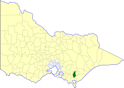 Location in Victoria | |||||||||||||
| Population | 27,320 (1992)[1] | ||||||||||||
| • Density | 40.727/km2 (105.482/sq mi) | ||||||||||||
| Established | 1892 | ||||||||||||
| Area | 670.81 km2 (259.0 sq mi) | ||||||||||||
| Council seat | Morwell | ||||||||||||
| County | Buln Buln, Tanjil | ||||||||||||
 | |||||||||||||
The City of Morwell was a local government area about 150 kilometres (93 mi) east-southeast of Melbourne, the state capital of Victoria, Australia. The city covered an area of 670.81 square kilometres (259.0 sq mi), and existed from 1892 until 1994.
History
Originally split between the Shires of Traralgon and Narracan, Morwell was first incorporated as a shire on 22 May 1892. On 11 December 1916, parts of the Boolarra and Yinnar ridings were annexed to the Shire of Mirboo. On 24 September 1947, under the terms of the State Electricity Commission (Yallourn Area) Act 1947, a town was proclaimed on 3.05 square kilometres (754 acres) at the Narracan-Morwell border; this self-governing area, under the auspices of the State Electricity Commission of Victoria, came to be known as the Yallourn Works Area, and at one point housed over 5,000 workers from nearby coal mines. On 28 August 1955, the Borough of Moe was severed from Narracan and incorporated, and land from Morwell's western riding was annexed to it. On 23 September 1990, Morwell was proclaimed a city.[2]
On 2 December 1994, the City of Morwell was abolished, and, along with the Cities of Moe and Traralgon, the Shire of Traralgon, and parts of the Shires of Narracan and Rosedale, was merged into the newly created City of Latrobe.[3]
Wards
The City of Morwell was divided into six wards on 3 August 1991, each of which elected two councillors:
- Churchill Ward
- Rural Ward
- West Ward
- North Ward
- East Ward
- South Ward
Towns and localities
- Boolarra
- Budgeree
- Churchill
- Darlimurla
- Driffield
- Gunyah
- Hazelwood
- Hazelwood North
- Jeeralang
- Jumbuk
- Livingston
- Morwell
- Yallourn North
- Yinnar
- Yinnar South
Population
| Year | Population |
|---|---|
| 1954 | 13,033 |
| 1958 | 15,460* |
| 1961 | 18,359 |
| 1966 | 20,773 |
| 1971 | 22,453 |
| 1976 | 22,654 |
| 1981 | 25,361 |
| 1986 | 26,743 |
| 1991 | 26,461 |
* Estimate in the 1958 Victorian Year Book.
References
- ↑ Australian Bureau of Statistics, Victoria Office (1994). Victorian Year Book. pp. 49–52. ISSN 0067-1223.
- ↑ Victorian Municipal Directory. Brunswick: Arnall & Jackson. 1992. pp. 433–434. Accessed at State Library of Victoria, La Trobe Reading Room.
- ↑ Australian Bureau of Statistics (1 August 1995). Victorian local government amalgamations 1994-1995: Changes to the Australian Standard Geographical Classification (PDF). Commonwealth of Australia. p. 8. ISBN 0-642-23117-6. Retrieved 2008-01-05.