Geography of French Polynesia
This article describes the geography of French Polynesia.
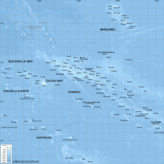
Map of French Polynesia
French Polynesia is located in Oceania. It is an archipelago in the South Pacific Ocean, about half way between South America and Australia (Geographic coordinates: 15°00′S 140°00′W / 15.000°S 140.000°W). Its area is about 4,167 km² (around 130 islands),[1] of which 3,827 km² is land and 340 km² is (inland) water. It has a coastline of 2,525 km but no land borders with order countries.
- Maritime claims
-
- Territorial sea: 12 nautical mile
- Exclusive economic zone: 200 nautical mile
- Climate
- Tropical, but moderate
- Terrain
- Mixture of rugged high islands and low islands with reefs
- Elevation extremes
-
- Lowest point: Pacific Ocean 0 m
- Highest point: Mont Orohena ( Tahiti ) 2,241 m
- Natural resources
- Timber, fish, cobalt, hydropower
- Land use
-
- Arable land: 0.68%
- Permanent crops: 6.28%
- Other: 93.03% (2012)
- Irrigated land
- 10 km2 (2003)
- Natural hazards
- Occasional cyclonic storms in January
- Environment - current issues
- NA
- Geography - note
- Includes five archipelagoes: four volcanic islands and one coral; Makatea in French Polynesia is one of the three great phosphate rock islands in the Pacific Ocean - the others are Banaba (Ocean Island) in Kiribati and Nauru
See also
References
- ↑ Kingfisher Geography Encyclopedia. ISBN 1-85613-582-9. Page 546
This article is issued from Wikipedia - version of the 8/19/2016. The text is available under the Creative Commons Attribution/Share Alike but additional terms may apply for the media files.