Close City, Texas
| Close City, Texas | |
|---|---|
| Unincorporated community | |
|
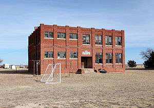
Close City school built 1919, abandoned 1965 | |
 Close City  Close City | |
| Coordinates: 33°12′39″N 101°29′14″W / 33.21083°N 101.48722°WCoordinates: 33°12′39″N 101°29′14″W / 33.21083°N 101.48722°W | |
| Country |
|
| State |
|
| County | Garza |
| Region | Llano Estacado |
| Established | 1906 |
| Founded by | C. W. Post |
| Elevation[1] | 2,933 ft (894 m) |
| Time zone | CST (UTC-6) |
| ZIP code | 79343 |
| Area code | 806 |
| Website | Handbook of Texas |
Close City is an unincorporated community in western Garza County, about 6.5 mi (10.5 km) west-northwest of Post, Texas. This small rural community lies on the high plains of the Llano Estacado in West Texas.
The rare motorist that happens to pass through the remote small town of Close City today may be unaware that, at the turn of the century, the town site was chosen as the original location of Post City, a model community and grand social experiment conceived by C. W. Post, an American breakfast cereal and foods manufacturer.[2] In the early 1890s, Post developed a popular caffeine-free coffee substitute called Postum and later made a fortune on breakfast cereals such as Grape Nuts and Post Toasties.[3] As Post's wealth grew, his interests began to expand into other areas. One project that had always intrigued him was the creation of a planned community of model homes and industry.[3] His success in the prepared foods industry provided the financial resources to make this dream a reality.
C. W. Post initially chose a site on the high plains of the Llano Estacado for his projected settlement.[4] Construction of Post City began at the original site until surveyors discovered that the town was 11 mi (18 km) from the geographical center of Garza County.[2] State law required a county seat to be located no more than 5 mi (8.0 km) from the center of a county and thus the chosen site could not serve as county seat.[3] Post ordered work to stop and he shifted resources to a site located nearer the center of the county. The new site, located below the Caprock, is the present-day location of Post, Texas.
The original town site was renamed Close City, named after Post's son-in-law, E. B. Close (Edward Bennett Close), who married his daughter Marjorie Merriweather Post in 1905.[5] Although some residents stayed, the town developed slowly and consequently remained a small rural community. Today, Close City is primarily a farming community and is surrounded by numerous sections of plowed land. The primary crop is cotton but lesser amounts of grain sorghum and winter wheat are also grown in the area. Crops are grown on a mixture of irrigated and dryland farms. Water for irrigation is pumped from the underlying Ogallala Aquifer and is applied using center pivot irrigation systems. The Ogallala Aquifer is quickly becoming depleted and, sometime in the future, all farms may have to revert to dryland agriculture.
In 1909, Close City students attended school in a one-room wooden schoolhouse. In 1919, George Samson and Jimmie Napier built a new brick schoolhouse, which served the community well until 1965, when Close City School was consolidated with Post, Texas.[6]
The only paved road that passes through Close City is Farm to Market Road 399. Close City is 2 mi (3.2 km) north of U.S. Highway 380 and 3 mi (4.8 km) west of U.S. Highway 84. The BNSF Railway, which extends from Post to Lubbock, passes 5 mi (8.0 km) to the east.
See also
References
- ↑ "Close City". Geographic Names Information System. United States Geological Survey.
- 1 2 Julius A. Amin, "Close City, TX," Handbook of Texas Online, http://www.tshaonline.org/handbook/online/articles/hrc72, accessed December 31, 2011, Published by the Texas State Historical Association.
- 1 2 3 Charles D. Eaves and C. A. Hutchinson. 1952. Post City, Texas. Austin: Texas State Historical Association, 171 pp.
- ↑ Donald R. Abbe and Paul H. Carlson. 2008. Historic Garza County: an Illustrated History. San Antonio: Historical Pub. Network, p. 23.
- ↑ Recorded Texas Historic Landmark: Old Close City School, erected in 1968 by the Texas Historical Commission, marker number 3710.
- ↑ Linda Puckett. 2010. Images of America: Garza County. Arcadia Publishing, p. 39.
External links
- U.S. Geological Survey Geographic Names Information System: Close City
- Close City, TX from the Handbook of Texas Online
- Public domain photos of the Llano Estacado
Municipalities and communities of Garza County, Texas, United States | ||
|---|---|---|
| City | 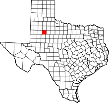 | |
| Unincorporated communities | ||