Columbia, Mississippi
| Columbia, Mississippi | |
|---|---|
| City | |
|
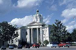
Marion County courthouse in Columbia | |
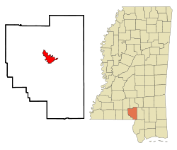 Location of Columbia, Mississippi | |
 Columbia, Mississippi Location in the United States | |
| Coordinates: 31°15′24″N 89°49′44″W / 31.25667°N 89.82889°WCoordinates: 31°15′24″N 89°49′44″W / 31.25667°N 89.82889°W | |
| Country | United States |
| State | Mississippi |
| County | Marion |
| Area | |
| • Total | 6.4 sq mi (16.6 km2) |
| • Land | 6.4 sq mi (16.5 km2) |
| • Water | 0.0 sq mi (0.0 km2) |
| Elevation | 148 ft (45 m) |
| Population (2000) | |
| • Total | 6,603 |
| • Density | 1,033.5/sq mi (399.0/km2) |
| Time zone | Central (CST) (UTC-6) |
| • Summer (DST) | CDT (UTC-5) |
| ZIP code | 39429 |
| Area code(s) | 601 |
| FIPS code | 28-15340 |
| GNIS feature ID | 0668715 |
Columbia is a city in Marion County, Mississippi, which was formed six years before Mississippi was admitted to statehood. Columbia was named for Columbia, South Carolina, from which many of the early settlers had migrated. The population was 6,603 as of the 2000 census. It is the county seat of Marion County.[1]
History
Columbia is the county seat of Marion County, Mississippi. Marion county was created out of Amite county in 1811, encompassing the southwest quarter of the current state of Mississippi. Before statehood in 1816, there were three territorial census/poll tax records taken of what was deemed Marion County at the time. These records reveal that during 1813, several LOTT men arrived and settled on the Pearl River in what is now Columbia. In 1813, William Lot was the largest slave holder near present-day Columbia, owning 28 slaves. There were five men, who settled south of present-day Columbia on 2,789 acres of land with 65 slaves. North of present-day Columbia, on what was the earliest attempt at a town, was Timothy Terrell on 3,151 acres with 32 slaves.
The land on which the current City of Columbia resides was first purchased for cash on April 18, 1820,by William Lott and John Lott. This land is Township 3 East, Range 18 West, Section 5 (640 acres),which is the center of the City of Columbia today. Other early patent holders of Columbia include James Phillips, Jr., and John Cooper (1825),in Section 4 next to John and William Lott.[2][3]
Columbia was officially incorporated on June 25, 1819, becoming the fourth municipality in the state of Mississippi. It served as the temporary capital of Mississippi from November, 1821, when the 5th session of the Mississippi Legislature first met there, until 1822. In that year, a special session of the legislature met in Columbia, inaugurating Governor Walter Leake, and selecting LeFleur's Bluff (now Jackson) as the permanent capital..
Columbia, "The City of Charm on the River Pearl", has always been in danger of flooding, due to its bordering the Pearl River. The county courthouse, and records dating back to pre-statehood, has managed to survive war, floods, tornadoes and hurricanes. In its first 100 years, Columbia relied on the Pearl River for transportation of goods. The river was much deeper and wider than it is now. Steamboat captains, such as John Black, lived in Columbia.[4]
During the Civil War, United States troops under the command of General Davidson camped outside Columbia, taking provisons from the citizens of the Conferdate States of America. The courthouse was spared. The Southern Claims Commission Files detail these events.[5]
During the Civil Rights Movement, Columbia, and Marion County were the site of the most peaceful demonstrations, due to the diligent insistence of non-violence by Sheriff John Homer Willoughby. The town is known for its citizens ability to work together.[6]
In 2004, Columbia suffered extensive damage from super storm Katrina. Once again, the courthouse survived. There was no looting, and citizens worked together with local churches, civic officials, and law enforcement to provide for citizens during the extensive power loss. Individuals immediately began helping their neighbors clear roads and escape being trapped in debris.
Former Mississippi governor and Columbia native Hugh L. White introduced white squirrels to the area, and they are still common in Columbia City Park. His home still stands yoday, a stately reminder of architecture of the past.
Pictures of Old Columia http://www.msmarion.com/columbiastreet.html
On December 23, 2014, an EF3 tornado ripped through areas around Columbia, killing four people and causing widespread damage.
Geography
Columbia is located on the east bank of the Pearl River and is 81 miles south of Jackson, Mississippi and 103 miles north of New Orleans, Louisiana. According to the United States Census Bureau, the city has a total area of 6.4 square miles (17 km2), all land.
Demographics
| Historical population | |||
|---|---|---|---|
| Census | Pop. | %± | |
| 1870 | 66 | — | |
| 1900 | 507 | — | |
| 1910 | 2,029 | 300.2% | |
| 1920 | 2,826 | 39.3% | |
| 1930 | 4,833 | 71.0% | |
| 1940 | 6,064 | 25.5% | |
| 1950 | 6,124 | 1.0% | |
| 1960 | 7,117 | 16.2% | |
| 1970 | 7,587 | 6.6% | |
| 1980 | 7,733 | 1.9% | |
| 1990 | 6,815 | −11.9% | |
| 2000 | 6,603 | −3.1% | |
| 2010 | 6,582 | −0.3% | |
| Est. 2015 | 6,229 | [7] | −5.4% |
As of the census[9] of 2000, there were 6,603 people, 2,497 households, and 1,620 families residing in the city. The population density was 1,033.5 people per square mile (399.0/km²). There were 2,821 housing units at an average density of 441.6 per square mile (170.5/km²). The racial makeup of the city was 62.56% White, 35.64% African American, 0.39% Native American, 0.44% Asian, 0.18% from other races, and 0.79% from two or more races. Hispanic or Latino of any race were 0.77% of the population.
There were 2,497 households out of which 29.5% had children under the age of 18 living with them, 41.5% were married couples living together, 19.7% had a female householder with no husband present, and 35.1% were non-families. 32.4% of all households were made up of individuals and 18.1% had someone living alone who was 65 years of age or older. The average household size was 2.38 and the average family size was 3.01.
In the city the population was spread out with 23.9% under the age of 18, 10.0% from 18 to 24, 26.0% from 25 to 44, 19.3% from 45 to 64, and 20.8% who were 65 years of age or older. The median age was 38 years. For every 100 females there were 88.1 males. For every 100 females age 18 and over, there were 83.7 males.
The median income for a household in the city was $19,644, and the median income for a family was $28,493. Males had a median income of $28,173 versus $17,847 for females. The per capita income for the city was $12,592. About 24.5% of families and 29.7% of the population were below the poverty line, including 41.0% of those under age 18 and 24.3% of those age 65 or over.
Government and infrastructure
The Mississippi Department of Human Services's Division of Youth Services operated the Columbia Training School in unincorporated Marion County, near Columbia.[10][11]
The mayor of Columbia is Robert R. Bourne, who was recently voted into office after defeating incumbent Reed Houston in the primary election.
Education
The City of Columbia is served by the Columbia School District, with Columbia High School as the public high school, and Columbia Academy, a private Christian school.
Notable people
- Jeff Bates - country music artist
- Gil Carmichael - businessman, transportation specialist, Republican politician, born in Columbia in 1927[12]
- Peggy Dow (Peggy Varnadow Helmerich) - film actress and philanthropist
- Jim Dunaway - NFL player for the Buffalo Bills and Miami Dolphins
- Reverend John Ford - pioneering Methodist minister and early political leader
- Bobby Hamilton - two-time Super Bowl winner with NFL's New England Patriots
- Gerry E. Hinton (1930–2000) - former member of Louisiana State Senate and Slidell, Louisiana City Council
- Claudis James - (1943-2013) NFL player
- General Benjamin Lee - military leader and early political figure
- Sylvester Magee - reportedly the last living American slave, died here in 1971
- Joseph T. "Joe" Owens - (1945-2013) NFL player
- Eddie Payton - pro football player
- Walter Payton - (1954-1999) NFL player in Pro Football Hall of Fame, born in Columbia
- Hugh L. White - former Columbia mayor and two-term Governor of Mississippi
December 23, 2014 tornado
At approximately 2:25PM, an EF3 tornado (as graded on the Enhanced Fujita Scale) hit Columbia, killing 2 people and requiring 50 people to receive treatment at Marion General Hospital. The tornado damaged several buildings in Columbia causing Governor Phil Bryant to declare a state of emergency for Jones and Marion Counties to offer state resources.[13]
References
| Wikimedia Commons has media related to Columbia, Mississippi. |
- ↑ "Find a County". National Association of Counties. Archived from the original on 2011-05-31.
- ↑ Mississippi State and Territorial Census
- ↑ Bureau of Land Management
- ↑ 1880 US Fed Census, Columbia, Marion Co, MS
- ↑ http://www.msmarion.com/history1863.html
- ↑ Columbian-Progress newspaper, 1960-1964,
- ↑ "Annual Estimates of the Resident Population for Incorporated Places: April 1, 2010 to July 1, 2015". Retrieved July 2, 2016.
- ↑ "Census of Population and Housing". Census.gov. Archived from the original on May 11, 2015. Retrieved June 4, 2015.
- ↑ "American FactFinder". United States Census Bureau. Archived from the original on 2013-09-11. Retrieved 2008-01-31.
- ↑ "Columbia city, Mississippi." U.S. Census Bureau. Retrieved on July 21, 2010.
- ↑ "Public Appearance Calendar Governor Ronnie Musgrove For the Week of December 31, 2001 Archived October 16, 2010, at the Wayback Machine.." Mississippi Department of Archives and History. Retrieved on July 21, 2010. "Columbia Training School 1730 Highway 44 Columbia, MS."
- ↑ "Gilbert E. Carmichael papers" (PDF). librarymsstate.edu. Retrieved May 5, 2014.
- ↑ "Four People Killed, 50 Others Injured After Tornado Hits Mississippi". Claudia Koerner. Retrieved 2014-12-25.
Municipalities and communities of Marion County, Mississippi, United States | ||
|---|---|---|
| Cities | 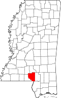 | |
| CDP | ||
| Other unincorporated communities | ||