Ponce Historic Zone
| Ponce Historic Zone Zona Histórica de Ponce | |
|---|---|
| Historic Zone | |
|
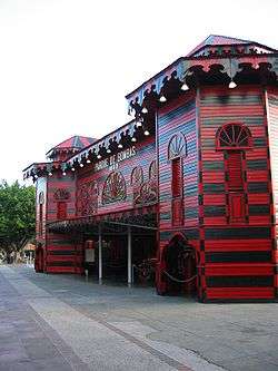
Parque de Bombas, the iconic symbol of the Historic Zone | |
| Nickname(s): La Perla del Sur | |
| Motto: Ponce es Ponce | |
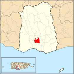 Map of the Historic Zone within the municipality of Ponce |
The Ponce Historic Zone (La Zona Histórica de Ponce) is a historic district in downtown Ponce, Puerto Rico, consisting of buildings and structures with architecture that date to the late nineteenth and early twentieth centuries.
The zone was originally designated in 1962, and initially included only the center core of the city, but it has since been expanded to include a much larger area.[1] On November 17, 2005, then-Governor of Puerto Rico, Aníbal Acevedo Vilá, signed Executive Order Number 72, approving the historic Ponce center as a Historic Center of First Order.[2] The zone goes by various names, including Ponce Tradicional (Traditional Ponce),[3] Ponce Centro (Ponce Center),[4] Ponce Histórico (Historic Ponce),[5] and Distrito Histórico (Historic District).[6]
Location
The zone is located in what is commonly called Ponce Pueblo ("Ponce Town") – the central downtown and oldest area of the city. While there are several roads that lead to it, the most typical point of entry is via PR-1 which, at its southern terminus, becomes Lolita Tizol street[7] and turns into Isabel street, leading to the heart of Ponce at the Plaza Las Delicias. A map of the area covered by the Ponce Historic Zone is available from the government of the municipality of Ponce.[8]
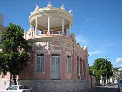
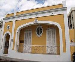
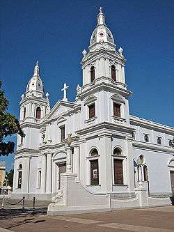
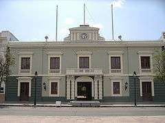
In addition to Plaza Las Delicias with its unique Parque de Bombas and Nuestra Señora de la Guadalupe Cathedral, the zone includes landmarks such as Ponce City Hall, Armstrong-Poventud Residence, Ponce High School, and Panteón Nacional Román Baldorioty de Castro. Numerous other attractions in this historic area are listed in the NRHP, such as Banco de Ponce, Casa Paoli, and Casa de la Masacre. Others, such as Teatro Fox Delicias, Teatro La Perla, Plaza de Mercado, Hotel Meliá, and Paseo Atocha are not listed but possess significant historical value.[9] Street corners in most of this zone have chamfered corners (Spanish: esquinas de chaflán), typical of Barcelona, Spain.
Ponce en Marcha
In recent years an intensive $440 million[10][11] revitalization project called "Ponce en Marcha"[12] ("Ponce on the Move") has increased the city's historic area from 260 to 1,046 buildings.[13] The Ponce en Marcha project was conceived in 1985 by then governor Rafael Hernández Colón during his second term in La Fortaleza. A significant number of buildings in Ponce are listed in the National Register of Historic Places.[14] The nonprofit Project for Public Places[15] listed the historic downtown Ponce city center as one of the 60 of the World's Great Places, for its "graciously preserved showcase of Caribbean culture".[16] The Ponce en Marcha project has given even more form to the definition, establishment, and development of the Ponce Historic Zone. The plan is the result of litigation between the Government of the Autonomous Municipality of Ponce and the Government of Puerto Rico.[17]
The Ponce en Marcha plan projects involve several departments of the Government of Puerto Rico:[18]
- The Puerto Rico Departamento de la Vivienda must complete the "Riberas del Bucaná III" residential project, and rehabilitate housing in the Baldorioty, La Ponderosa, and Lomas de Guaraguao sectors. It must rehabilitate the homes in the Puerto Viejo sector in barrio Playa plus 200 units of uninhabited lots citywide, restart the program "Tu Ciudad Renace", and demolish the housing project "Residencial Las Terrazas".
- The Puerto Rico Autoridad de Carreteras must comply with the construction of the bridge at the intersection of PR-2 and Punto Oro, the two projects required to complete the Anillo de Circunvalación de Ponce, and three bridges over Avenida Maruca.
- The Puerto Rico Autoridad de Edificios Públicos, must swap land belonging to the Puerto Rico Police Marine Unit in exchange for improvements to "Parque Julio González", and must complete the construction of the Ponce Headquarters of the Puerto Rico Police.
- The Puerto Rico Autoridad de Energía Eléctrica must complete Phase III of the burial of aerial cabling within the "Zona Histórica", as well as Phase VI.
- The Puerto Rico Autoridad de Acueductos Alcantarillados must complete the design of the water filtration plant at barrio Cerrillos, the acquisition of land for its construction and its distribution network.
- The Puerto Rico Autoridad de los Puertos must expand the runway and taxiway at Mercedita Airport and build the maintenance building.
- The Puerto Rico Departamento de Recursos Naturales must comply with the construction of the Portugués and Bucaná rivers lineal park, as well as the canalization of the Matilde, Pastillo y Canas rivers and the development of the La Matilde Natural Reserve and the Caja de Muertos Light.
Designation categories
Structures within the historic zone are classified into four categories:[19]
- The first consists of structures "with a monumental historic value", and part of the city’s heritage.
- The second is for those structures that while lacking a monumental historic value, possess some qualities of historic, architectural, or cultural interest.
- The third category includes those structures of contextual value. These are those structures that may not intrinsically possess historic, architectural, or cultural value individually, they but do enhance the area when they are considered contextually, as part of a larger group, as part of urban characteristic, or as part of the architecture of a section of a street.
- And finally, category 4 is reserved for those structures that exist within the historic zone but whose value has not been assessed, that is, they are unclassified.
Sub-zones
The historic zone itself consists of three distinct sub-zones:[20]
- First Order Zone – This zone is limited to the area immediately surrounding Plaza Las Delicias. This is the original historic zone, created in 1962.
- Second Order Zone – This is a zone that was added in 1989 further increasing the perimeter of the area around Plaza Las Delicias.
- Third Order Zone – This zone was added in 1992, and it covered the communities of Mariani, Belgica, and parts of Clausells, and Cantera. It was also extended, for the first time, east of Rio Portugues, to cover the community of La Alhambra.
In August, 2003, Mayor Cordero favored a measure to exclude Belgica, Claussells, and Cantera — all poor, low-income communities — from the historic zone.[20]
See also
- National Register of Historic Places in Ponce, Puerto Rico
| Wikimedia Commons has media related to Ponce Historic Zone. |
References
- ↑ Mario Santana. Revitalizacion por Ley. El Nuevo Dia. 12 February 2004.
- ↑ Executive Order Number 72, of November 17, 2005 Retrieved May 4, 2010.
- ↑ Apoyo Ponceño al Parquimetro. El Nuevo Dia. 13 January 2007. Retrieved 5 May 2010.
- ↑ Great Public Places: Ponce Center City. Maria Fernanda Vallecillo. Project for Public Spaces, New York, New York. "Ponce Center City." Retrieved 11 December 2009.
- ↑ Explore Puerto Rico. "Historic Ponce." Page 240. Retrieved 11 December 2009.
- ↑ Frommer's Portable Puerto Rico. Darwin Porter and Danforth Prince. Volume 10. Second Ed. Wiley Publishing. Pages 7-8. "Historic District." Retrieved 11 December 2009.
- ↑ Culminan Fiestas del Tricentenario. El Nuevo Dia. March 12, 1992. Page 105.
- ↑ Mapa Interactivo. Government of the Autonomous Municipality of Ponce. Accessed 10 October 2011.
- ↑ Restauran Cine Teatro en Ponce. El Nuevo Dia. May 18, 1991.
- ↑ Introduction to Ponce. Frommer's $440M Renovation Project. Retrieved December 4, 2005.
- ↑ Welcome to Puerto Rico: Ponce. Nearly one half a billion dollars have been spent preserving the colonial core of Ponce. Retrieved November 30, 2009.
- ↑ Identity, Power, and Place @ the Margins. Revolutionary Ideas in Planning. Proceeding of the 1998 National Planning Conference. By Wanda I. Mills. AICP Press. Ponce en Marcha. Retrieved November 30, 2009.
- ↑ Explore Puerto Rico. By Harry S. Pariser. Page 242 Downtown revitalization brought historic buildings up to 1,046. Retrieved December 7, 2009.
- ↑ National Register of Historic Places - buildings and structures
- ↑ Great Public Places: Ponce Center City. Project for Public Spaces, New York, New York. By Maria Fernanda Vallecillo. Project for Public Spaces. Retrieved November 30, 2009.
- ↑ 60 of the World's Great Places. Project for Public Spaces: Thirty Years of Placemaking. New York, New York. Retrieved November 30, 2009.
- ↑ Denuncia Seilhamer Rodríguez: Imponen trabas al futuro de Mercedita. Jason Rodríguez Grafal. La Perla del Sur. Ponce, Puerto Rico. Retrieved 11 October 2011.
- ↑ Arturo Picó Valls: Confía en juez del pleito Ponce en Marcha. Reinaldo Millán. La Perla del Sur. Ponce, Puerto Rico. Retrieved 21 October 2011.
- ↑ Cambios en la Normas en Busca de Repoblar. El Nuevo Dia. June 9, 2006. By Mario Santana Ortiz.
- 1 2 Revitalizacion por Ley. El Nuevo Dia. February 12, 2004.
Coordinates: 18°00′41.6874″N 66°36′50.22″W / 18.011579833°N 66.6139500°W