Tolland, Connecticut
| Tolland, Connecticut | ||
|---|---|---|
| Town | ||
| ||
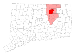 Location in Tolland County, Connecticut | ||
| Coordinates: 41°52′19.85″N 72°22′10.06″W / 41.8721806°N 72.3694611°WCoordinates: 41°52′19.85″N 72°22′10.06″W / 41.8721806°N 72.3694611°W | ||
| Country | United States | |
| State | Connecticut | |
| NECTA | Hartford | |
| Region | Capitol Region | |
| Incorporated | 1715 | |
| Government | ||
| • Type | Council-manager | |
| • Town manager | Steven Werbner | |
| • Town council |
Jack Scavone (R), Chm. George Baker (R), Vice Chm. Rick Field (D) Jan Rubino (D) William Eccles (R) Ben Stanford (R) Paul Krasusky (D) | |
| Area | ||
| • Total | 40.3 sq mi (104.4 km2) | |
| • Land | 39.7 sq mi (102.9 km2) | |
| • Water | 0.6 sq mi (1.5 km2) | |
| Elevation | 656 ft (200 m) | |
| Population (2010) | ||
| • Total | 15,052 | |
| • Density | 372.6/sq mi (145.3/km2) | |
| Time zone | Eastern (UTC-5) | |
| • Summer (DST) | Eastern (UTC-4) | |
| ZIP code | 06084 | |
| Area code(s) | 860 | |
| FIPS code | 09-76290 | |
| GNIS feature ID | 0212667 | |
| Website |
www | |

Tolland is a town in Tolland County, Connecticut, United States. The population was 15,052 at the 2010 census.
History
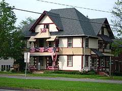
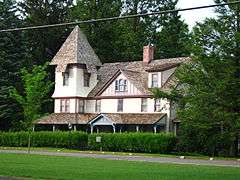
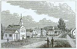
Tolland was named in May, 1715, and incorporated in May, 1722. According to some, the town derives its name from being a toll station on the old road between Boston and New York. Alternatively, its name could have been taken after Tolland in Somerset, England. Today Interstate 84, the main highway connecting New York City, Hartford, Connecticut and Boston, bisects Tolland, but the town retains a charming village feel. Tolland Green is the informal center of the community, and a national historic district. The Green's features include an old-fashioned penny candy and antiques store known to locals as the 'Red and White'; the town's original 19th-century town hall, now an arts center; the 'Old Tolland Jail' museum; the 'Tolland Inn' bed and breakfast; and the Hicks-Stearns Museum, a restored Victorian house. The architectural styles on display, including the white steeples of several churches, are reminiscent of a picture-postcard New England scene. The town is also home to the supposedly haunted 'Benton Homestead'.
Many of the town's adults work in Hartford, located about 25 minutes away, often at one of the city's many insurance companies, or for the neighbouring University of Connecticut in Storrs to the south. A family-oriented town, the landscape of Tolland is primarily composed of large houses, and mansions on plots of around two acres. Undeveloped, forested land covers the area between the town's many residential developments. Containing two state forests and several municipal parks, the town retains a relatively rural character.
In September 2006 Tolland opened the new Tolland High School to support the growing number of students. The town is also expanding with new commercial and residential developments.
Tolland is an affluent town, and has ranked among "Best places to live in America" by CNN/Money magazine in the "small town" category several times:
| Year | Ranking |
|---|---|
| 2005 | 29th[1] |
| 2009 | 27th[2] |
| 2011 | 37th[3] |
| 2015 | 34th[4] |
In April 2008, Wes Craven began filming scenes for his 2009 movie My Soul to Take inside the former Tolland High School.[5]
Geography
According to the United States Census Bureau, the town has a total area of 40.3 sq mi (104.4 km2), of which 39.7 sq mi (102.8 km2) is land and 0.58 sq mi (1.5 km2) (1.46%) is water.
Nearby towns include Coventry, Ellington, Mansfield, Stafford, Vernon, and Willington, Connecticut.
| Climate data for Tolland, Connecticut | |||||||||||||
|---|---|---|---|---|---|---|---|---|---|---|---|---|---|
| Month | Jan | Feb | Mar | Apr | May | Jun | Jul | Aug | Sep | Oct | Nov | Dec | Year |
| Average high °F (°C) | 33 (1) |
37 (3) |
44 (7) |
56 (13) |
67 (19) |
75 (24) |
79 (26) |
78 (26) |
71 (22) |
60 (16) |
50 (10) |
38 (3) |
57.3 (14.2) |
| Average low °F (°C) | 18 (−8) |
22 (−6) |
28 (−2) |
38 (3) |
47 (8) |
57 (14) |
62 (17) |
60 (16) |
53 (12) |
42 (6) |
35 (2) |
24 (−4) |
40.5 (4.8) |
| Average precipitation inches (mm) | 3.79 (96.3) |
3.47 (88.1) |
4.44 (112.8) |
4.53 (115.1) |
3.97 (100.8) |
4.46 (113.3) |
3.94 (100.1) |
3.81 (96.8) |
4.09 (103.9) |
4.60 (116.8) |
4.57 (116.1) |
4.21 (106.9) |
49.88 (1,267) |
| Source: [6] | |||||||||||||
Demographics
| Historical population | |||
|---|---|---|---|
| Census | Pop. | %± | |
| 1820 | 1,597 | — | |
| 1850 | 1,406 | — | |
| 1860 | 1,310 | −6.8% | |
| 1870 | 1,216 | −7.2% | |
| 1880 | 1,169 | −3.9% | |
| 1890 | 1,037 | −11.3% | |
| 1900 | 1,036 | −0.1% | |
| 1910 | 1,126 | 8.7% | |
| 1920 | 1,040 | −7.6% | |
| 1930 | 1,064 | 2.3% | |
| 1940 | 1,192 | 12.0% | |
| 1950 | 1,659 | 39.2% | |
| 1960 | 2,950 | 77.8% | |
| 1970 | 7,857 | 166.3% | |
| 1980 | 9,694 | 23.4% | |
| 1990 | 11,001 | 13.5% | |
| 2000 | 13,146 | 19.5% | |
| 2010 | 15,052 | 14.5% | |
| Est. 2014 | 14,872 | [7] | −1.2% |
As of the census[9] of 2000, there were 13,146 people, 4,586 households, and 3,788 families residing in the town. The population density was 331.0 people per square mile (127.8/km²). There were 4,665 housing units at an average density of 117.5 per square mile (45.4/km²). The racial makeup of the town was 97.36% White, 0.57% African American, 0.08% Native American, 1.19% Asian, 0.02% Pacific Islander, 0.39% from other races, and 0.81% from two or more races. Hispanic or Latino of any race were .75% of the population.
There were 4,586 households out of which 42.3% had children under the age of 18 living with them, 74.4% were married couples living together, 1.9% had a female householder, and 17.4% were non-families. 13.0% of all households were made up of individuals and 4.1% had someone living alone who was 65 years of age or older. The average household size was 2.83 and the average family size was 3.12.
In the town the population was spread out with 28.3% under the age of 18, 5.4% from 18 to 24, 31.7% from 25 to 44, 26.8% from 45 to 64, and 7.7% who were 65 years of age or older. The median age was 37 years. For every 100 females there were 99.3 males. For every 100 females age 18 and over, there were 97.1 males. The median income for a household in the town was $135,398 as of Census 2000, and, according to CNN/Money magazine's 2009 "Best Places to Live", the median income for a family in 2009 was $136,772.[2] Males had a median income of $91,659 versus $57,795 for females. The per capita income for the town was $54,571. About .6% of families and .7% of the population were below the poverty line, including .5% of those under age 18 and .2% of those age 65 or over.
Government
Tolland was governed by town meeting until November 1973, when it adopted a new charter.[10] The principal governing body of Tolland is the elected Town Council, which is responsible for making policy and major decisions about the town's future. The day-to-day operations of the town are handled by a Town Manager, a paid professional appointed by the Council and charged with implementing and executing Council policy and decisions.
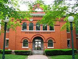
The Council consists of seven unpaid members elected in a general election in the town every two years. Currently, the Council consists of four Republicans and three Democrats, and was elected in November 2013. The council selects their own chair and vice-chairpersons, with the chair traditionally being the highest vote-getter among the four majority-party members and the vice-chair the highest among the minority party members. Except for Executive Sessions (which are usually held to re-negotiate contracts with Town employees) meetings are open to the public and contain a time for citizens to address the Council from the floor. As of December 2005, meetings were held on the 2nd and 4th Tuesdays of the month at 7:30pm at the Hicks Municipal Building at 21 Tolland Green.
Notable locations
- The Daniel Benton Homestead was built in 1720 and is the oldest home in Tolland. It is now a museum.[11]
- The Old County Jail and Museum (Tolland, Connecticut) is a property including the 1856 jail which operated until 1968 and attached Jailer's home.[12]
On the National Register of Historic Places
- Tolland County Courthouse- listed on the National Register of Historic Places (NRHP) in 1977.
- Tolland Green Historic District – founded in 1706 and added to the National Register of Historic Places in 1997.
Notable people
- Edward K. Beale (1970-), Author, USCG helicopter pilot during Hurricane Katrina; raised in Tolland and graduated from Tolland High School.
- Daniel C. Burbank (1961–), NASA astronaut; raised in Tolland and graduated from Tolland High School.
- Henry D. Cogswell (1820–1900), dentist and a crusader in the temperance movement; born in Tolland.[13]
- William W. Eaton (1816–1898), US Congressman and US Senator; born in Tolland and a resident of Tolland.[14]
- Jonathan Hatch Hubbard (1768–1849), US Congressman for Vermont; born in Tolland.[15]
- Charles R. Ladd (1822–1903), lawyer, politician and Massachusetts Auditor; born in Tolland.
- David Passaro (1966–), CIA contractor and former US Army Ranger; graduated from Tolland High School.[16]
- Shubal Stearns (1706–1771), evangelist, preacher of the Separate Baptists; resident of Tolland.[17]
- James Stevenson (1981–), actor; raised in Tolland.[18]
- Ingeborg B. Swanback (1940-1992), Connecticut 20th Century Pilgrim; Born in Munich Germany - resident of Tolland [19]
- Loren P. Waldo (1802–1881), lawyer and US Congressman; resident of Tolland.[20]
- Nancy Wyman, Lieutenant Governor of Connecticut and former State Controller; resident of Tolland.[21]
References
- ↑ http://money.cnn.com/magazines/moneymag/bplive/2005/snapshots/36588.html
- 1 2 http://money.cnn.com/magazines/moneymag/bplive/2009/snapshots/CS0976290.html
- ↑ http://money.cnn.com/magazines/moneymag/bplive/2011/snapshots/CS0976290.html
- ↑ http://time.com/money/3984469/tolland-connecticut-best-places-to-live-2015/
- ↑ http://www.upi.com/Entertainment_News/2008/04/05/Craven-filming-at-old-Conn-high-school/UPI-36431207411499/
- ↑ "Monthly Averages for Tolland, CT (06084)". Weather.com. March 2012. Retrieved March 18, 2012.
- ↑ "Annual Estimates of the Resident Population for Incorporated Places: April 1, 2010 to July 1, 2014". Retrieved June 4, 2015.
- ↑ "Census of Population and Housing". Census.gov. Retrieved June 4, 2015.
- ↑ "American FactFinder". United States Census Bureau. Retrieved 2008-01-31.
- ↑ http://www.tolland.org/about/
- ↑ http://www.tollandhistorical.org/danielbentonhomestead
- ↑ http://www.connecticutsar.org/sites/2009/06/the-old-county-jail-and-museum.html
- ↑ "Cogswell Fountain". Rockville CT. Retrieved October 24, 2012.
- ↑ "EATON, William Wallace, (1816 - 1898)". Biographical Directory of the United States Congress. Retrieved October 24, 2012.
- ↑ "HUBBARD, Jonathan Hatch, (1768 - 1849)". Biographical Directory of the United States Congress. Retrieved October 24, 2012.
- ↑ "Shubal Stearns (1706-1771)". The New York Times. Retrieved October 24, 2012.
- ↑ "Shubal Stearns (1706-1771)". North Carolina History Project. Retrieved October 24, 2012.
- ↑ "James Stevenson". IMDb. Retrieved October 24, 2012.
- ↑ Template:Library of congress catalog no: 77-73319
- ↑ "WALDO, Loren Pinckney, (1802 - 1881)". Biographical Directory of the United States Congress. Retrieved October 24, 2012.
- ↑ "LIEUTENANT GOVERNOR NANCY WYMAN". Office of the Lieutenant Governor. Retrieved October 24, 2012.
External links
- Tolland Town Government
- Ghost of The Benton Homestead
- Central Regional Tourism District
- 2005 CNN best Places to Live
Municipalities and communities of Tolland County, Connecticut, United States | ||
|---|---|---|
| Towns | 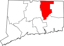 | |
| Other communities | ||
