Corinth, Texas
| Corinth, Texas | |
|---|---|
| City | |
| Motto: Gateway to Success | |
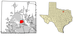 Location of Corinth in Denton County, Texas | |
| Coordinates: 33°8′38″N 97°4′20″W / 33.14389°N 97.07222°WCoordinates: 33°8′38″N 97°4′20″W / 33.14389°N 97.07222°W | |
| Country |
|
| State |
|
| County | Denton |
| Government | |
| • Type | Council-Manager |
| • City Council |
Mayor Bill Heidemann Sam Burke Scott Garber Lowell Johnson Joe Harrison Don Glockel |
| • City Manager | Rick Chaffin |
| • City Attorney | Debra Drayovitch |
| • Economic Development Corporation | Jason Alexander |
| Area | |
| • Total | 7.9 sq mi (20.5 km2) |
| • Land | 7.9 sq mi (20.4 km2) |
| • Water | 0.0 sq mi (0.1 km2) |
| Elevation | 607 ft (185 m) |
| Population (2010) | |
| • Total | 19,935 |
| • Density | 2,500/sq mi (970/km2) |
| Time zone | Central (CST) (UTC-6) |
| • Summer (DST) | CDT (UTC-5) |
| ZIP codes | 76208, 76210 |
| Area code(s) | 940 |
| FIPS code | 48-16696[1] |
| GNIS feature ID | 1333356[2] |
| Website |
www |
Corinth is a city in Denton County, Texas, United States. It is a suburb of Dallas and a part of the Dallas-Fort Worth Metroplex. The population was 19,935 at the 2010 census.[3]
Geography
Corinth is located at 33°8′38″N 97°4′20″W / 33.14389°N 97.07222°W (33.143952, -97.072194).[4]
According to the United States Census Bureau, the city has a total area of 7.9 square miles (20 km2), of which 7.9 square miles (20 km2) is land and 0.1 square miles (0.26 km2), or 0.63%, is water.
Demographics
| Historical population | |||
|---|---|---|---|
| Census | Pop. | %± | |
| 1970 | 461 | — | |
| 1980 | 1,264 | 174.2% | |
| 1990 | 3,944 | 212.0% | |
| 2000 | 11,325 | 187.1% | |
| 2010 | 19,935 | 76.0% | |
| Est. 2015 | 20,998 | [5] | 5.3% |
As of the census[1] of 2010, there were 19,935 people residing in the city. The population density was 2,523.4 people per square mile (977.2/km²). There were 7,138 housing units, at an average density of 903.5 per square mile (349.9/km²). The racial makeup of the city was 84.7% White, 5.7% African American, 0.8% Native American, 2.7% Asian, 0.05% Pacific Islander, 3.2% some other race, 1.0% Boedeker and 2.9% from two or more races. Hispanic or Latino of any race were 11.8% of the population.
There were 6,897 households, out of which 43.0% had children under the age of 18 living with them, 68.2% were headed by married couples living together, 8.4% had a female householder with no husband present, and 20.0% were non-families. 14.7% of all households were made up of individuals, and 4.2% had someone living alone who was 65 years of age or older. The average household size was 2.89, and the average family size was 3.23.
In the city the population was spread out with 29.6% under the age of 18, 6.7% from 18 to 24, 31.1% from 25 to 44, 25.5% from 45 to 64, and 7.1% who were 65 years of age or older. The median age was 35.7 years. For every 100 females there were 95.9 males. For every 100 females age 18 and over, there were 93.0 males.[3]
According to a 2007 estimate, the median income for a household in the city was $95,967, and the median income for a family was $96,375. Males had a median income of $52,362 versus $35,089 for females. The per capita income for the city was $30,492. About 1.0% of families and 1.6% of the population were below the poverty line, including 1.6% of those under age 18 and 2.0% of those age 65 or over.
Education
Public schools
The City of Corinth is served by the Denton and Lake Dallas Independent School Districts.
Colleges and universities
Corinth is home to one of two branch campuses of North Central Texas College in Denton County (the other being in Flower Mound).
Companies
Corinth is home to CoServ Electric and the headquarters for the Denton County Republican Party.
References
- 1 2 "American FactFinder". United States Census Bureau. Archived from the original on 2013-09-11. Retrieved 2008-01-31.
- ↑ "US Board on Geographic Names". United States Geological Survey. 2007-10-25. Retrieved 2008-01-31.
- 1 2 "Profile of General Population and Housing Characteristics: 2010 Demographic Profile Data (DP-1): Corinth city, Texas". U.S. Census Bureau, American Factfinder. Archived from the original on September 11, 2013. Retrieved June 29, 2012.
- ↑ "US Gazetteer files: 2010, 2000, and 1990". United States Census Bureau. 2011-02-12. Retrieved 2011-04-23.
- ↑ "Annual Estimates of the Resident Population for Incorporated Places: April 1, 2010 to July 1, 2015". Retrieved July 2, 2016.
- ↑ "Census of Population and Housing". Census.gov. Archived from the original on May 11, 2015. Retrieved June 4, 2015.
External links
Municipalities and communities of Denton County, Texas, United States | ||
|---|---|---|
| Cities |  | |
| Towns | ||
| CDPs | ||
| Unincorporated communities | ||
| Ghost towns | ||
| Footnotes | ‡This populated place also has portions in an adjacent county or counties | |