Crozier, Virginia
| Crozier, Virginia | |
|---|---|
| Unincorporated community | |
 Crozier, Virginia  Crozier, Virginia | |
| Coordinates: 37°38′13″N 77°47′50″W / 37.63694°N 77.79722°WCoordinates: 37°38′13″N 77°47′50″W / 37.63694°N 77.79722°W | |
| Country | United States |
| State | Virginia |
| County | Goochland |
| Elevation | 325 ft (99 m) |
| Time zone | Eastern (EST) (UTC-5) |
| • Summer (DST) | EDT (UTC-4) |
| ZIP code | 23039 |
| Area code(s) | 804 |
| GNIS feature ID | 1477238[1] |
Crozier is an unincorporated community in Goochland County, Virginia, United States. Crozier is located on Virginia State Route 6 5.8 miles (9.3 km) east-southeast of Goochland. Crozier has a post office with ZIP code 23039.[2]
The First Union School and Springdale are listed on the National Register of Historic Places.[3]
Crozier is the location of the Basic Correctional Officer's Academy, where the state's Correctional Officers are trained.
Climate
The climate in this area is characterized by hot, humid summers and generally mild to cool winters. According to the Köppen Climate Classification system, Crozier has a humid subtropical climate, abbreviated "Cfa" on climate maps.[4]
References
- ↑ "Crozier". Geographic Names Information System. United States Geological Survey.
- ↑ United States Postal Service (2012). "USPS - Look Up a ZIP Code". Retrieved 2012-02-15.
- ↑ National Park Service (2010-07-09). "National Register Information System". National Register of Historic Places. National Park Service.
- ↑ Climate Summary for Crozier, Virginia
Municipalities and communities of Goochland County, Virginia, United States | ||
|---|---|---|
| CDP | 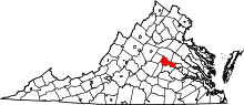 | |
| Unincorporated communities | ||
This article is issued from Wikipedia - version of the 7/27/2016. The text is available under the Creative Commons Attribution/Share Alike but additional terms may apply for the media files.