Cumberland City, Tennessee
| Cumberland City, Tennessee | |
|---|---|
| Town | |
|
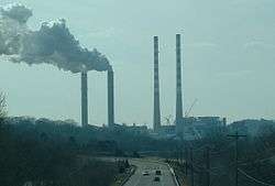
Cumberland Power Plant at Cumberland City | |
 Location of Cumberland City, Tennessee | |
| Coordinates: 36°23′26″N 87°38′27″W / 36.39056°N 87.64083°WCoordinates: 36°23′26″N 87°38′27″W / 36.39056°N 87.64083°W | |
| Country | United States |
| State | Tennessee |
| County | Stewart |
| Area | |
| • Total | 5.3 sq mi (13.7 km2) |
| • Land | 4.8 sq mi (12.5 km2) |
| • Water | 0.5 sq mi (1.2 km2) |
| Elevation | 384 ft (117 m) |
| Population (2010) | |
| • Total | 311 |
| • Density | 65.6/sq mi (25.3/km2) |
| Time zone | Central (CST) (UTC-6) |
| • Summer (DST) | CDT (UTC-5) |
| ZIP code | 37050 |
| Area code(s) | 931 |
| FIPS code | 47-18820[1] |
| GNIS feature ID | 1306226[2] |
Cumberland City is a town in Stewart County, Tennessee. The population was 311 at the 2010 census.[3] It is part of the Clarksville, TN — Kentucky Metropolitan Statistical Area.
Cumberland City is the site of a TVA Cumberland Power Plant along the Cumberland River that provides 2.6 gigawatts of electric power to much of the area, including the cities of Clarksville in Montgomery County and Dickson in Dickson County.
The power plant's towers (some of the tallest structures in the state) can be seen for at least 30 miles (48 km) away.
Geography
Cumberland City is located at 36°23′26″N 87°38′27″W / 36.39056°N 87.64083°W (36.390469, -87.640801).[4]
According to the United States Census Bureau, the town has a total area of 5.3 square miles (13.7 km2), of which 4.8 square miles (12 km2) is land and 0.5 square miles (1.3 km2), or 8.9% is water.
There is an impact crater centered at Wells Creek, just south of the Cumberland power plant.[5]
Demographics
| Historical population | |||
|---|---|---|---|
| Census | Pop. | %± | |
| 1890 | 244 | — | |
| 1920 | 400 | — | |
| 1930 | 313 | −21.7% | |
| 1960 | 314 | — | |
| 1970 | 416 | 32.5% | |
| 1980 | 276 | −33.7% | |
| 1990 | 319 | 15.6% | |
| 2000 | 316 | −0.9% | |
| 2010 | 311 | −1.6% | |
| Est. 2015 | 302 | [6] | −2.9% |
| Sources:[7][8] | |||
As of the census[1] of 2000, there were 316 people, 139 households, and 89 families residing in the town. The population density was 65.6 people per square mile (25.4/km²). There were 178 housing units at an average density of 37.0 per square mile (14.3/km²). The racial makeup of the town was 87.34% White, 7.91% African American, 0.63% Asian, 2.22% from other races, and 1.90% from two or more races. Hispanic or Latino of any race were 2.22% of the population.
There were 139 households out of which 24.5% had children under the age of 18 living with them, 43.2% were married couples living together, 14.4% had a female householder with no husband present, and 35.3% were non-families. 29.5% of all households were made up of individuals and 17.3% had someone living alone who was 65 years of age or older. The average household size was 2.27 and the average family size was 2.80.
In the town the population was spread out with 22.5% under the age of 18, 10.1% from 18 to 24, 23.4% from 25 to 44, 22.5% from 45 to 64, and 21.5% who were 65 years of age or older. The median age was 40 years. For every 100 females there were 91.5 males. For every 100 females age 18 and over, there were 88.5 males.
The median income for a household in the town was $21,750, and the median income for a family was $26,250. Males had a median income of $31,875 versus $17,500 for females. The per capita income for the town was $14,363. About 22.8% of families and 27.3% of the population were below the poverty line, including 37.9% of those under the age of 18 and 23.8% of those 65 and older.
Media
Radio Stations
- WTPR-FM 101.7 - "The Greatest Hits of All Time"
- WTPR-AM 710 - "The Greatest Hits of All Time"
References
- 1 2 "American FactFinder". United States Census Bureau. Archived from the original on 2013-09-11. Retrieved 2008-01-31.
- ↑ "US Board on Geographic Names". United States Geological Survey. 2007-10-25. Retrieved 2008-01-31.
- ↑ Tennessee Department of Economic and Community Development, Certified Population of Tennessee Incorporated Municipalities and Counties, State of Tennessee official website, 14 July 2011. Retrieved: 6 December 2013.
- ↑ "US Gazetteer files: 2010, 2000, and 1990". United States Census Bureau. 2011-02-12. Retrieved 2011-04-23.
- ↑ Wells Creek, Earth Impact Database http://www.unb.ca/passc/ImpactDatabase/images/wells-creek.htm
- ↑ "Annual Estimates of the Resident Population for Incorporated Places: April 1, 2010 to July 1, 2015". Retrieved July 2, 2016.
- ↑ "Census of Population and Housing: Decennial Censuses". United States Census Bureau. Retrieved 2012-03-04.
- ↑ "Incorporated Places and Minor Civil Divisions Datasets: Subcounty Resident Population Estimates: April 1, 2010 to July 1, 2012". Population Estimates. U.S. Census Bureau. Archived from the original on 17 June 2013. Retrieved 11 December 2013.
Municipalities and communities of Stewart County, Tennessee, United States | ||
|---|---|---|
| City | ||
| Towns | ||
| Unincorporated communities | ||
| Ghost town | ||
| Footnotes | ‡This populated place also has portions in an adjacent county or counties | |