Westwood, Queensland
| Westwood Queensland | |||||||||||||
|---|---|---|---|---|---|---|---|---|---|---|---|---|---|
 Westwood | |||||||||||||
| Coordinates | 23°36′51″S 150°9′24″E / 23.61417°S 150.15667°ECoordinates: 23°36′51″S 150°9′24″E / 23.61417°S 150.15667°E | ||||||||||||
| Population | 220 (2011 census)[1] | ||||||||||||
| Postcode(s) | 4702 | ||||||||||||
| Location |
| ||||||||||||
| LGA(s) | |||||||||||||
| State electorate(s) | Fitzroy | ||||||||||||
| Federal Division(s) | Flynn | ||||||||||||
| |||||||||||||
Westwood is a town in the Rockhampton Region and a locality split between the Rockhampton Region and the Shire of Banana in Queensland, Australia.[2][3][4] It was the first town gazetted by the Queensland Government. In the 2011 census, Westwood had a population of 220 people.[1]
Geography
Westwood is 50 kilometres (31 mi) south west of the city of Rockhampton. The Capricorn Highway passes through the town, and the intersection with the Leichhardt Highway is a few kilometres to the southwest. The town of Westwood consists of a handful of houses, a hotel, and a police station.The major industry of the area is cattle grazing. The northern half of the locality of Westwood is in Rockhampton Region while the southern part is in the Shire of Banana.[5]
History
Although towns such as Brisbane, Maryborough and Rockhampton had been gazetted by the New South Wales Government prior to the separation of Queensland, Westwood was the first town to be gazetted by the newly established Queensland Government on 23 May 1860. Although the area was named Prestone on the original survey plan, Queensland Governor George Bowen decided to name the town Westwood after Westwood House, the home of Sir John Pakington, the Secretary of State for the Colonies and War in 1852.[2][6]
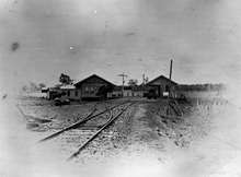
In 1867, the Great Northern Railway (now known as the Central Western Line) reached the area from Rockhampton, and Westwood became the railhead.[7] The first load of wool was railed from the town on 23 August.
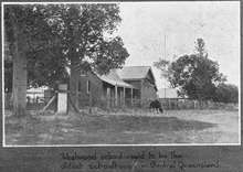
Westwood State School opened on 26 August 1872.[8][9]
The town was meant to be the railhead for only a short time; however, bureaucracy and financial difficulties for the state meant that the next section of the line did not commence construction until 1873. The significance of Westwood declined when the railhead moved further west.
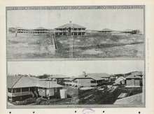
In 1919 a 64-bed sanitorium was opened in Westwood to treat miner's phthisis, a lung disease suffered by miners from working in dusty conditions. Later it treated patients with tuberculous. In 1953, a ¾ mile bitumen road was built from the Huxham railway siding (just to the north of Westwood) to the sanitorium and named Haigh Drive in memory of Leonard Garfield Haigh, the former chairman of the Rockhampton Hospitals Board from 2 June 1933 to 16 February 1953. Commencing with a tiled-roof waiting shed at the siding with a plaque commemorating Haigh, the drive to the sanitorium was flanked with peltophorum trees and was officially opened by James Larcombe (MLA for Rockhampton) in the presence of Haigh's widow on Sunday 1 November 1953.[10][11] More effective medical treatments for tuberculous resulted in the closure of the sanitorium in 1959, but the building continued to be used as a nursing home until the 1980s. The sanitorium buildings were then relocated or demolished; one is in use as a private home in Emerald.[12]
At the 2006 census, Westwood and the surrounding area had a population of 253.[13]
Heritage listings
Westwood has the following heritage-listed sites:
- remains of the Adolphus William Copper Smelter [14]
Education
Westwood State School is a government co-educational primary school (P-6) in Herbert Street. In 2014, the school had an enrolment of 9 children with 2 teachers (1 full-time equivalent).[15]
References
- 1 2 Australian Bureau of Statistics (31 October 2012). "Westwood". 2011 Census QuickStats. Retrieved 26 December 2015.
- 1 2 "Westwood - town (entry 37148)". Queensland Place Names. Queensland Government. Retrieved 27 December 2015.
- ↑ "Westwood - locality in Rockhampton Region (entry 48930)". Queensland Place Names. Queensland Government. Retrieved 27 December 2015.
- ↑ "Westwood - locality in Banana Shire (entry 49579)". Queensland Place Names. Queensland Government. Retrieved 27 December 2015.
- ↑ "Queensland Globe". State of Queensland. Retrieved 26 December 2015.
- ↑ "Westwood celebrates its place in Queensland's 150 year history". statements.qld.gov.au. Retrieved 2015-12-26.
- ↑ The Centenary of the Central Line Knowles, J.W. Australian Railway Historical Society Bulletin, September, 1967 pp181-202
- ↑ "Opening and closing dates of Queensland Schools". Queensland Government. Retrieved 26 December 2015.
- ↑ "Agency ID5823, Westwood State School". Queensland State Archives. Retrieved 26 December 2015.
- ↑ "HAIGH DRIVE OPENED.". The Central Queensland Herald (Rockhampton, Qld. : 1930 - 1956). Rockhampton, Qld.: National Library of Australia. 5 November 1953. p. 11. Retrieved 27 December 2015.
- ↑ "No title.". The Central Queensland Herald (Rockhampton, Qld. : 1930 - 1956). Rockhampton, Qld.: National Library of Australia. 5 November 1953. p. 11. Retrieved 27 December 2015."No title.". The Central Queensland Herald (Rockhampton, Qld. : 1930 - 1956). Rockhampton, Qld.: National Library of Australia. 5 November 1953. p. 11. Retrieved 27 December 2015.
- ↑ "Westwood Sanatorium on opening day 1919". www.achha.org.au. Retrieved 2015-12-26.
- ↑ Australian Bureau of Statistics (25 October 2007). "Westwood (Fitzroy Shire) (State Suburb)". 2006 Census QuickStats. Retrieved 2009-07-25.
- ↑ "Adolphus William Copper Smelter and Dee Township (entry 700013)". Queensland Heritage Register. Queensland Heritage Council. Retrieved 12 July 2013.
- ↑ "2014 Annual Report". Westwood State School. 30 June 2015. Retrieved 26 December 2015.
Further reading
- Hansen, Ronald James (1971), The geology of the Westwood Intrusion, Central Eastern Queensland, Brisbane
- Hanrahan, Gail Marguerite (1997), Westwood State School : 125 years, 26 August 1872-1997, Westwood State School
- Hoch, Isabel (2009), Medical care at Westwood 1919-1984, Rockhampton & District Historical Society, retrieved 27 December 2015
External links
| Wikimedia Commons has media related to Westwood, Queensland. |
- "Westwood". Central Queensland Family History Association Inc. Retrieved 26 December 2015.