Cusco Region
| Cusco Region | ||
|---|---|---|
| Region | ||
|
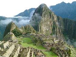
Machu Picchu, the lost city of the Inca | ||
| ||
.svg.png) Location of the Cusco region in Peru | ||
| Coordinates: 13°16′S 72°07′W / 13.26°S 72.11°WCoordinates: 13°16′S 72°07′W / 13.26°S 72.11°W | ||
| Country | Peru | |
| Subdivisions | 13 provinces and 108 districts | |
| Largest city | Cusco | |
| Capital | Cusco | |
| Government | ||
| • President | Hugo Gonzalez | |
| Area | ||
| • Total | 71,986 km2 (27,794 sq mi) | |
| Elevation(Capital) | 3,399 m (11,152 ft) | |
| Highest elevation | 4,801 m (15,751 ft) | |
| Lowest elevation | 532 m (1,745 ft) | |
| Population (2005 Census) | ||
| • Total | 1,171,503 | |
| • Density | 16/km2 (42/sq mi) | |
| UBIGEO | 08 | |
| Dialing code | 0484 | |
| ISO 3166 code | PE-CUS | |
| Principal resources | Gold, maize, barley, quinoa, and tea | |
| Poverty rate | 5.3% | |
| Percentage of Peru's GDP | 4.4% | |
| Website | www.regioncusco.gob.pe/ | |

Cusco (Quechua: Qosqo suyu, also spelled Cuzco) is a region in Peru. It is bordered by the Ucayali Region on the north; the Madre de Dios and Puno regions on the east; the Arequipa Region on the south; and the Apurímac, Ayacucho and Junín regions on the west. Its capital is Cusco, the capital of the Inca Empire.[1]
Provinces
- Acomayo (Acomayo)
- Anta (Anta)
- Calca (Calca)
- Canas (Yanaoca)
- Canchis (Sicuani)
- Chumbivilcas (Santo Tomás)
- Cusco (Cusco)
- Espinar (Yauri)
- La Convención (Quillabamba)
- Paruro (Paruro)
- Paucartambo (Paucartambo)
- Quispicanchi (Urcos)
- Urubamba (Urubamba)
Geography
The plain of Anta contains some of the best communal cultivated lands of the Cusco Region. It is located about 3,000 metres (9,800 ft) above sea level and is used to cultivate mainly high altitude crops such as potatoes, tarwi (edible lupin), barley and quinoa.
Languages
According to the 2007 Peru Census, the language learnt first by most of the residents was Quechua (51.40%) followed by Spanish (46.86%). The Quechua variety spoken in Cusco is Cusco Quechua. The following table shows the results concerning the language learnt first in the Cusco Region by province:[2]
| Province | Quechua | Aymara | Asháninka | Another native language | Spanish | Foreign language | Deaf or mute | Total |
|---|---|---|---|---|---|---|---|---|
| Acomayo | 22,262 | 12 | 2 | 4 | 3,117 | - | 52 | 25,449 |
| Anta | 36,512 | 42 | 3 | 10 | 15,248 | 8 | 132 | 51,955 |
| Calca | 43,008 | 101 | 4 | 117 | 18,128 | 13 | 142 | 61,513 |
| Canas | 32,790 | 31 | 6 | 11 | 2,910 | - | 40 | 35,788 |
| Canchis | 53,695 | 107 | 5 | 7 | 37,702 | 2 | 120 | 91,638 |
| Chumbivilcas | 64,087 | 102 | 9 | 1 | 6,063 | 2 | 104 | 70,368 |
| Cusco | 63,675 | 781 | 94 | 306 | 282,610 | 1,521 | 466 | 349,453 |
| Espinar | 40,594 | 120 | 8 | 1 | 18,116 | 6 | 71 | 58,916 |
| La Convención | 62,145 | 276 | 2,802 | 9,278 | 81,111 | 120 | 318 | 156,050 |
| Paruro | 26,707 | 53 | 5 | 1 | 2,192 | 1 | 42 | 29,001 |
| Paucartambo | 35,996 | 95 | 15 | 207 | 5,682 | 9 | 65 | 42,069 |
| Quispicanchi | 57,587 | 152 | 11 | 12 | 18,562 | 20 | 86 | 76,430 |
| Urubamba | 27,523 | 104 | 4 | 9 | 25,075 | 823 | 68 | 53,606 |
| Total | 566,581 | 1,976 | 2,968 | 9,964 | 516,516 | 2,525 | 1,706 | 1,102,236 |
| % | 51.40 | 0.18 | 0.27 | 0.90 | 46.86 | 0.23 | 0.15 | 100.00 |
Gallery
-
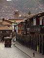
Balconies at the main square in Cusco
See also
Sources
- ↑ Official page (in Spanish)
- ↑ inei.gob.pe Archived January 27, 2013, at the Wayback Machine. INEI, Peru, Censos Nacionales 2007
External links
Peru's Lima Province is not part of any region. |