Daigle, Maine
| Daigle | |
|---|---|
| Town | |
|
Daigle, 1915 | |
 Daigle  Daigle | |
| Coordinates: 47°11′22″N 68°27′39″W / 47.18944°N 68.46083°WCoordinates: 47°11′22″N 68°27′39″W / 47.18944°N 68.46083°W | |
| Country | United States |
| State | Maine |
| County | Aroostook |
| Elevation | 712 ft (217 m) |
| Time zone | Eastern (EST) (UTC-5) |
| • Summer (DST) | EDT (UTC-4) |
| GNIS feature ID | 564738[1] |
.jpg)
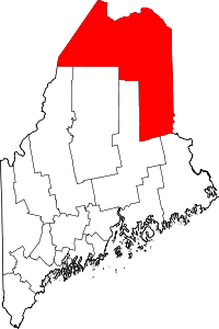
Daigle, Maine is a town in Aroostook County, Maine, United States.[1]
The settlement is located 8 mi (13 km) south of Fort Kent. Daigle Pond and Dam are located there.[2]
History
The first settlers were Vital Daigle and his wife Julie Cyr.[3] They came from Frenchville, Maine seeking a new home for their family.[4] The deed to the property was dated 1858, and listed 13 Daigle family members.[3]
Other settlers from Frenchville followed, and the small community of "Daigle" developed.[4]
In 1882, Vital Daigle developed a property called "New Canada Plantation" south of the family homestead, where Daigle manufactured lumber.[3][5]
The township adopted the name New Canada, as did the nearby town of New Canada.[6]
Daigle had a post office from 1899 to 1933,[7] and Vital Daigle was the first postmaster.[8]
A church called Holy Family Parish was built in 1906. A cemetery was also established. In 1909, the church was destroyed by fire, but was rebuilt the following year. The church closed in 2000 and was demolished, and a monument was erected to mark its place. The property was sold to the town of New Canada where a community center was to be built. The cemetery is extant, and contains the graves on many early families.[4][9]
References
- 1 2 U.S. Geological Survey Geographic Names Information System: Daigle
- ↑ U.S. Geological Survey Geographic Names Information System: Daigle Pond Dam
- 1 2 3 Ancestry Daig (March 16, 2011). "Vital Daigle". Find A Grave.
- 1 2 3 Roy, Ken. "Holy Family Parish History". Our Acadian, French-Canadian, and Maine Ancestors. Retrieved November 25, 2016.
- ↑ Maine Register or State Year-book and Legislative Manual. J. B. Gregory. 1888. p. 273.
- ↑ U.S. Geological Survey Geographic Names Information System: Town of New Canada
- ↑ U.S. Geological Survey Geographic Names Information System: Daigle Post Office (historical)
- ↑ "Aroostook County" (PDF). Doubleday Postal History. Retrieved November 25, 2016.
- ↑ U.S. Geological Survey Geographic Names Information System: Holy Family Cemetery