De Haan, Belgium
| De Haan | |||
|---|---|---|---|
| Municipality | |||
 | |||
| |||
 De Haan Location in Belgium | |||
|
Location of De Haan in West Flanders 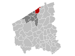 | |||
| Coordinates: 51°16′N 03°02′E / 51.267°N 3.033°ECoordinates: 51°16′N 03°02′E / 51.267°N 3.033°E | |||
| Country | Belgium | ||
| Community | Flemish Community | ||
| Region | Flemish Region | ||
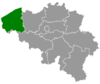
| Province | West Flanders | ||
| Arrondissement | Ostend | ||
| Government | |||
| • Mayor | Peter Breemersch (Bewust '12) | ||
| • Governing party/ies | Bewust '12 | ||
| Area | |||
| • Total | 42.17 km2 (16.28 sq mi) | ||
| Population (1 January 2016)[1] | |||
| • Total | 12,622 | ||
| • Density | 300/km2 (780/sq mi) | ||
| Postal codes | 8420, 8421 | ||
| Area codes | 059 - 050 | ||
| Website | www.dehaan.be | ||

De Haan (French: Le Coq; West Flemish: D'n Oane) is a place and a municipality located in the Belgian province of West Flanders. The municipality comprises the villages of De Haan proper, Klemskerke, Vlissegem and Wenduine. On January 1, 2006 De Haan had a total population of 11,925. The total area is 42.17 km² which gives a population density of 283 inhabitants per km².
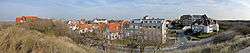
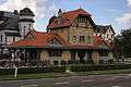
The coastal village of De Haan proper has maintained a low skyline so its many buildings in Belle Époque style are still prominently visible.
The town has an 18-hole golf course situated in its dunes, founded by King Leopold II in 1903. Today, it is the only links course in the country.
Its most famous resident was Albert Einstein, who lived in the villa "Savoyarde" for six months in 1933 after leaving Nazi Germany.
Photo gallery
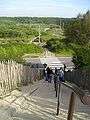 Dunes between De Haan and Wenduine
 Street in the Concessie
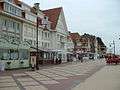 Beachfront Shops
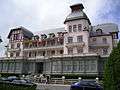 Municipal Hall of De Haan
Sports
Women's volleyball club Volley De Haan plays at the highest level of the Belgian league pyramid.
Transport
De Haan has stations on The Coast Tram.
References
- ↑ Population per municipality as of 1 January 2016 (XLS; 397 KB)
External links
| Wikimedia Commons has media related to De Haan, Belgium. |
- Official website - Information available in Dutch and limited information available in French, English and German
- photos of De Haan
 |
North Sea | Blankenberge | | |
| Bredene | |
Zuienkerke | ||
| ||||
| | ||||
| Ostend | Oudenburg, Jabbeke |