Delaware Route 48
| ||||
|---|---|---|---|---|
 | ||||
| Route information | ||||
| Maintained by DelDOT | ||||
| Length: | 7.09 mi[1] (11.41 km) | |||
| Existed: | 1936[2] – present | |||
| Major junctions | ||||
| West end: |
| |||
|
| ||||
| East end: |
| |||
| Location | ||||
| Counties: | New Castle | |||
| Highway system | ||||
| ||||

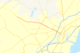
Delaware Route 48 (DE 48) is a state highway in New Castle County, Delaware. The route runs from DE 41 in Hockessin east to U.S. Route 13 Business (US 13 Bus.) in downtown Wilmington. The route passes through suburban areas of Wilmington such as Lancaster Pike, intersecting DE 100 and DE 141. DE 48 continues into Wilmington as Lancaster Avenue and intersects DE 2, where it splits into the one-way pair of Lancaster Avenue eastbound and Second Street westbound. Upon reaching downtown Wilmington, the route intersects Interstate 95 (I-95)/US 202 and DE 4 before continuing to the eastern terminus.
What is now DE 48 was originally built as the Lancaster Pike in 1817, a turnpike that was to connect Wilmington to the Gap and Newport Turnpike. The turnpike became county maintained in 1877. The Lancaster Pike became DE 48 by 1936, with the route continuing east through Wilmington to the Wilmington-Penns Grove Ferry across the Delaware River, where it connected to Route 48 in Penns Grove, New Jersey. The ferry was discontinued in 1949 and the eastern terminus of DE 48 was cut back to its current location by 1952.
Route description

DE 48 begins at an intersection with DE 41 in Hockessin, heading southeast on Lancaster Pike, a two-lane undivided road. The road runs through wooded areas and residential development, curving east and gaining a second westbound lane. The route widens into a four-lane divided highway and passes to the north of Delaware National Country Club before crossing the Wilmington and Western Railroad and Red Clay Creek. DE 48 comes to an intersection with DE 100/DE 141, at which point DE 100 forms a concurrency with DE 48. The two routes head southeast as a four-lane undivided road, passing through residential and commercial areas. The road crosses an East Penn Railroad line and runs to the north of a cemetery, with DE 100 splitting from DE 48 by turning south on South Dupont Road as it passes south of the Cab Calloway School of the Arts and Charter School of Wilmington.[3][4]
DE 48 continues into Wilmington as Lancaster Avenue and heads into areas of homes and businesses, with the eastbound direction narrowing to one lane at an intersection with Greenhill Avenue. Following this intersection, the route crosses over CSX's Philadelphia Subdivision on a bridge. The road narrows to two lanes and passes to the north of another cemetery. The route intersects DE 2, which follows the one-way pair of Lincoln Street northbound and Union Street southbound, in the Union Park Gardens neighborhood.[3][4]
At this point, DE 48 itself splits into a one-way pair that follows Lancaster Avenue eastbound and West Second Street westbound, with westbound DE 48 using westbound DE 2 (North Union Street) to get from West Second Street to Lancaster Avenue. The one-way pair carries two lanes in each direction. DE 48 continues into downtown Wilmington, where it crosses under a viaduct carrying I-95/US 202, with ramp connections to and from the southbound direction of I-95/US 202 via Jackson Street, which parallels I-95/US 202 to the west.[3][4]
Upon crossing under I-95/US 202, a westbound ramp to I-95/US 202 complements the eastbound direction of DE 48, with the road becoming Martin Luther King, Jr. Boulevard, a six-lane divided highway. Westbound DE 48 remains along one-way West Second Street, which carries three lanes. DE 48 intersects the eastern terminus of DE 4, which provides access to DE 48 from the northbound direction of I-95/US 202. The one-way pair continues further into the downtown and runs a short distance to the north of Amtrak's Northeast Corridor. The route intersects the southbound direction of US 13 Bus., which shifts west from North King Street to South Market Street where it intersects DE 48. Following the intersection with US 13 Bus. southbound, DE 48 follows the one-way pair of East Front Street eastbound and East Second Street westbound, passing to the north of Wilmington Station along the Northeast Corridor that serves Amtrak and SEPTA's Wilmington/Newark Line. DE 48 reaches its eastern terminus at an intersection with the northbound direction of US 13 Bus., which follows Walnut Street.[3][4]
DE 48 has an annual average daily traffic count ranging from a high of 30,195 vehicles at the DE 4 intersection to a low of 13,264 vehicles at the McKennans Church Road intersection near Hockessin.[1] The entire length of DE 48 is part of the National Highway System.[5]
History
The Wilmington Turnpike Company was founded on October 23, 1809 to build a turnpike from Wilmington to the Pennsylvania border, connecting to the Gap and Newport Turnpike. The turnpike was completed in 1817 at a cost of $39,549.97.[6] The turnpike became known as the Lancaster Pike and was surfaced with stone. The Wilmington Turnpike Company operated the Lancaster Pike until 1877 when they abandoned the road. The turnpike's charter was repealed and the road was then under the control of the county levy court.[6][7] The road leading to the Wilmington-Penns Grove Ferry across the Delaware River between Wilmington and Penns Grove, New Jersey was completed as a state highway by 1931.[8]
By 1936, the Lancaster Pike became a part of DE 48. In addition, the route continued through Wilmington on Lincoln Street, Fourth Street, and Christiana Avenue to the ferry across the Delaware River to Penns Grove, New Jersey, where it connected to Route 48 in New Jersey.[2] In 1939, DE 48 was rebuilt between DE 41 and Centre Road, eliminating curves and grades.[9] In 1949, the Wilmington-Penns Grove Ferry was discontinued.[10] DE 48 was realigned onto Lancaster Avenue to continue to US 13/US 202 (now US 13 Bus.), its current eastern terminus, by 1952.[11] By 1990, DE 100 was realigned to follow a portion of DE 48, bypassing a part of Dupont Road.[12] DE 48 was widened into a divided highway at the DE 141 intersection by 1996.[13] The divided highway was extended west to Centerville Road a year later.[14]
Major intersections
The entire route is in New Castle County.
| Location | mi[1] | km | Destinations | Notes | |
|---|---|---|---|---|---|
| Hockessin | 0.00 | 0.00 | Western terminus | ||
| Wilmington | 3.83 | 6.16 | West end of DE 100 overlap | ||
| 4.86 | 7.82 | East end of DE 100 overlap | |||
| 5.69 | 9.16 | DE 48 splits into one-way pair, brief overlap between westbound DE 2 and westbound DE 48 | |||
| 6.40 | 10.30 | Interchange, access from northbound I-95/US 202 provided by DE 4, I-95/US 202 exit 6 | |||
| 6.56 | 10.56 | ||||
| 6.98 | 11.23 | ||||
| 7.09 | 11.41 | Eastern terminus | |||
1.000 mi = 1.609 km; 1.000 km = 0.621 mi
| |||||
See also
 U.S. Roads portal
 Delaware portal
References
- 1 2 3 Staff (2011). "Traffic Count and Mileage Report: Interstate, Delaware, and US Routes" (PDF). Delaware Department of Transportation. Retrieved May 17, 2012.
- 1 2 Delaware State Highway Department; The National Survey Co. (1936). Official Road Map of the State of Delaware (PDF) (Map) (1936–37 ed.). Dover: Delaware State Highway Department. Retrieved November 24, 2015.
- 1 2 3 4 Delaware Department of Transportation (2008). Delaware Official Transportation Map (PDF) (Map). Dover: Delaware Department of Transportation. Retrieved November 24, 2015.
- 1 2 3 4 Google (January 8, 2012). "overview of Delaware Route 48" (Map). Google Maps. Google. Retrieved January 8, 2012.
- ↑ National Highway System: Delaware (PDF) (Map). Federal Highway Administration. 2010. Retrieved February 10, 2012.
- 1 2 Scharf, John Thomas. History of Delaware : 1609-1888, Volume 1. Philadelphia: L.J. Richards & Co. pp. 416–417. Retrieved January 8, 2012.
- ↑ Delaware Federal Writers Project. Delaware: a guide to the first state. New York City: The Viking Press. p. 450. Retrieved January 8, 2012.
- ↑ Delaware State Highway Department (1931). Official Road Map of the State of Delaware (PDF) (Map). Dover: Delaware State Highway Department. Retrieved November 24, 2015.
- ↑ "Annual Report of the State Highway Department" (PDF) (1939 ed.). Dover, Delaware: Delaware State Highway Department. January 1, 1940: 17. Retrieved November 11, 2014.
- ↑ Delaware State Highway Department (1949). Official Road Map of the State of Delaware (PDF) (Map). Dover: Delaware State Highway Department. Retrieved November 24, 2015.
- ↑ Delaware State Highway Department (1952). Official Highway Map of Delaware (PDF) (Map) (1952–53 ed.). Dover: Delaware State Highway Department. Retrieved November 24, 2015.
- ↑ Delaware Department of Transportation (1990). Official State Map (PDF) (Map). Dover: Delaware Department of Transportation. Retrieved November 24, 2015.
- ↑ Delaware Department of Transportation; Division of Planning Cartographic Information Section (1996). Delaware Official State Map (PDF) (Map). Dover: Delaware Department of Transportation. Retrieved November 24, 2015.
- ↑ Delaware Department of Transportation (1997). Official Transportation Map (PDF) (Map). Dover: Delaware Department of Transportation. Retrieved November 24, 2015.
External links
 Media related to Delaware Route 48 at Wikimedia Commons