Diu, India
| Diu | |
|---|---|
| City | |
|
Zampa Gateway - Diu | |
 Diu Location in India | |
| Coordinates: 20°43′N 70°59′E / 20.71°N 70.98°ECoordinates: 20°43′N 70°59′E / 20.71°N 70.98°E | |
| Country |
|
| State | Daman and Diu |
| District | Diu |
| Government | |
| • Type | Municipal corporation |
| Area | |
| • Total | 40 km2 (20 sq mi) |
| Elevation | 0 m (0 ft) |
| Population (2001) | |
| • Total | 21,576 |
| • Density | 540/km2 (1,400/sq mi) |
| Languages | |
| • Official | Gujarati, English |
| Time zone | IST (UTC+5:30) |
| Sex ratio | 0.85 ♂/♀ |
.jpg)
Diu is a town in Diu district in the union territory of Daman and Diu, India. Diu District is the tenth least populated district of India.
The town of Diu lies at the eastern end of Diu Island, and is known for its fortress and old Portuguese Cathedral. It is also a fishing town.
Diu has been selected as one of the hundred Indian cities to be developed as a smart city under PM Narendra Modi's flagship Smart Cities Mission.
History
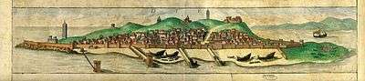

The town and district were historically part of the Saurashtra region of Gujarat and an important port on trade routes of Arabian sea of Indian Ocean.
Due to its strategic importance, there was a Battle of Diu in 1509 between Portugal and a combined force of Turkey, Egypt, Venice, the Republic of Ragusa (now known as Dubrovnik) and the Sultan of Gujarat, Mahmud Begada. In 1513, the Portuguese tried to establish an outpost there, but negotiations were unsuccessful. There were failed attempts by Diogo Lopes de Sequeira in 1521, Nuno da Cunha in 1523. In 1531 the conquest attempted by D. Nuno da Cunha was also not successful.
In 1535 Bahadur Shah, the Sultan of Gujarat, concluded a defensive alliance with the Portuguese against the Mughal emperor Humayun, and allowed the Portuguese to construct the Diu Fort and maintain a garrison on the island.
The alliance quickly unraveled, and attempts by the Sultans to oust the Portuguese from Diu between 1537 and 1546 failed. Having repented of his generosity, Bahadur Shah sought to recover Diu, but was defeated and killed by the Portuguese, followed by a period of war between them and the people of Gujarat. In 1538, Coja Sofar, lord of Cambay, together with the Turkish Suleiman Pasha of Ottoman Empire, came to lay siege to Diu, and were defeated by Portuguese resistance led by Anthony Silveira. A second siege was imposed by the same Coja Sofar, in 1546, and repelled by the Portuguese conquerors, led on land by D. John Mascarenhas, and at sea, by D. João de Castro. Coja Sofar and D. Fernando de Castro, son of the Portuguese viceroy, perished in the struggle. The fortress, completed by Dom João de Castro after the siege of 1545, still stands.
After this second siege, Diu was so fortified that it could withstand later attacks of the Arabs of Muscat and the Dutch in the late 17th century. From the 18th century, Diu declined in strategic importance, due to development of Bombay and came to be reduced to a museum or historical landmark as commercial and strategic bulwark in the struggle between the forces of the Islamic East and Christian West.
Diu remained in the possession of the Portuguese from 1535 until 1961, when it fell in the possession of the troops of the Indian Union, which invaded all of former Portuguese India under Operation Vijay. The island was occupied by the Indian military on 19 December 1961. The Battle of Diu involved overwhelming land, sea and air strikes on the enclave for 48 hours until the Portuguese garrison there surrendered. It was declared union territory of India, Goa, Daman, and Diu. Goa separated as a state in 1987, thus the remainder became union territory of Daman and Diu.
Population
.jpg)
Languages
The languages spoken in Diu include Gujarati, Portuguese, English and Hindi.
Demographics
As of 2001 India census,[1] Diu had a population of 21,576. Males constitute 46% of the population and females 54%. Diu has an average literacy rate of 71%, falling below the 2011 national average of 74.04%. Male literacy is 81% and female literacy is 69%. In Diu, 13% of the population is under 6 years of age.
Geography and climate
.jpg)

Diu is located at 20°43′N 70°59′E / 20.71°N 70.98°E.[2] The island is at sea level and covers an area of 38.8 km². The climate is extremely warm and humid, with an average annual rainfall of 1500 mm.
General Information
With no tall buildings except the fort, Diu has a characteristically low skyline.
Old Diu is known for its Portuguese architecture.
Diu Fort was built in 1535 and maintained an active garrison until 1960.[3] The Diu fort is the most visited landmarks in the district. The Diu fort and the Basilica of Bom Jesus in Old Goa were chosen as the two wonders from India, among the seven from across the world, out of a list of 27 monuments built in 16 countries during the Portuguese rule. Fort is built on a hillock next to the sea. There are only remains of the fort now but the fort in itself must have been a very romantic place once upon a time.
There are three Portuguese Baroque churches, with St. Paul’s Church, completed in 1610, being the only one still in use for its original purpose. The Church of St. Francis of Assisi, the first church built in Diu, in 1593, is now used as a hospital. St. Thomas Church is currently used as a museum.
An ancient Lord Shiva's Temple is located on the Gangeswar coast.
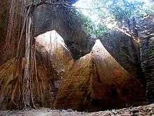
Naida Caves are located near Jalandhar Beach.
INS Khukri or Khukeri memorial is located near the Jalandhar Beach. The place is known for its open amphitheatre and breaktaking sunset shots.
The nearby Nagoa beach and offshore lighthouse are popular tourist destinations, and the coast is a popular recreational area for parasailing, boating, and jet skiing.
Local transport is available from Una, Gujarat. Air India Regional and Jet Airways service the island from the mainland, landing at Diu Airport.
There are several hotels and resorts and there is a growing hotel and leisure industry.
Unlike in Gujarat State, alcohol is legal in Diu.
Trivia: Many people confuse Diu with Daman. Although people refer to them together, they are different places (approximately 650 km from each other).
See also
References
- ↑ "Census of India 2001: Data from the 2001 Census, including cities, villages and towns (Provisional)". Census Commission of India. Archived from the original on 2004-06-16. Retrieved 2008-11-01.
- ↑ Falling Rain Genomics, Inc - Diu
- ↑ Bradnock, Roma (2004). Footprint India. Diu town. Footprint Travel Guides. pp. 1171–72. ISBN 978-1-904777-00-7. Retrieved 2011-03-01.
Further reading
- Andrada (undated). The Life of Dom John de Castro: The Fourth Vice Roy of India. Jacinto Freire de Andrada. Translated into English by Peter Wyche. (1664). Henry Herrington, New Exchange, London. Facsimile edition (1994) AES Reprint, New Delhi. ISBN 81-206-0900-X.
External links
![]() Media related to Diu at Wikimedia Commons
Media related to Diu at Wikimedia Commons