Diu district
| Diu district Distrito de Diu | |
|---|---|
| District | |
 Diu district Diu district location | |
| Coordinates: 20°43′N 70°59′E / 20.71°N 70.98°ECoordinates: 20°43′N 70°59′E / 20.71°N 70.98°E | |
| Country |
|
| Union territory | Daman and Diu |
| District | Diu |
| Area | |
| • Total | 40 km2 (20 sq mi) |
| Elevation | 0 m (0 ft) |
| Population (2011) | |
| • Total | 52,056 |
| • Density | 1,300/km2 (3,400/sq mi) |
| Languages | |
| • Official | Gujarati, English |
Diu district (Portuguese: Distrito de Diu) is one of the two districts of Daman and Diu, a union territory of India. It is the ninth least populous district in the country (out of 640).[1]
History
The district was historically part of the Saurashtra region of Gujarat.[2]
Mirroring the system of administrative division in Portugal, Diu district (Distrito de Diu) was established as an administrative division of the Portuguese State of India (Estado da Índia) in the first half of the 19th century. It was headed by a district governor, subordinate to the governor-general of Portuguese India in Goa. The district included the single municipality of Diu, which was further subdivided into civil parishes.
It remained an overseas territory of Portugal until it was annexed by Indian forces on 19 December 1961. From 1961-87, it was a part of the union territory of Goa, Daman and Diu. In 1987, it became a part of the newly formed union territory of Daman and Diu.
Geography
Diu district occupies an area of 40 square kilometres (15 sq mi),[3]
It consists of Diu Island and a part on the mainland (the Ghoghla peninsula).
Diu Island
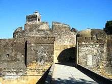
Diu Island is the place where the town of Diu is located. Diu Fort is also located on Diu Island.
Mainland
The area on the mainland borders Gir Somnath district of Gujarat. It contains the village of Ghoghla.
The village lies on the mainland opposite the eastern end of the island.
Demographics
According to the 2011 census Diu district has a population of 52,056,[1] roughly equal to the nation of Saint Kitts and Nevis.[4] This gives it a ranking of 631st in India (out of a total of 640).[1] The district has a population density of 1,301 inhabitants per square kilometre (3,370/sq mi) .[1] Its population growth rate over the decade 2001-2011 was 17.73%.[1] Diu has a sex ratio of 1030 females for every 1000 males,[1] and a literacy rate of 83.36%.[1]
References
- 1 2 3 4 5 6 7 "District Census 2011". Census2011.co.in. 2011. Retrieved 2011-09-30.
- ↑ History of Diu - DIU TOURISM DEPARTMENT - INDIA
- ↑ Srivastava, Dayawanti et al. (ed.) (2010). "States and Union Territories: Daman and Diu: Government". India 2010: A Reference Annual (54th ed.). New Delhi, India: Additional Director General, Publications Division, Ministry of Information and Broadcasting (India), Government of India. p. 1216. ISBN 978-81-230-1617-7.
- ↑ US Directorate of Intelligence. "Country Comparison: Population". Retrieved 2011-10-01.
Saint Kitts and Nevis 50,314 July 2011 est.
External links
 |
Gir Somnath district, Gujarat | | ||
| Arabian Sea | |
Gulf of Khambhat | ||
| ||||
| | ||||
| Arabian Sea |