Drogheda
| Drogheda Droichead Átha | |||
|---|---|---|---|
| Town | |||
|
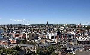
2007 view of Drogheda from the south | |||
| |||
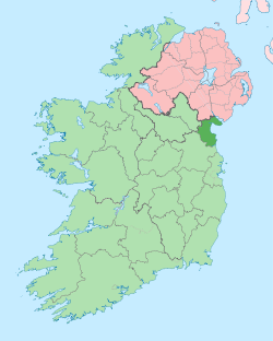
 Drogheda Location in Ireland | |||
| Coordinates: 53°42′50″N 6°21′01″W / 53.713889°N 6.350278°WCoordinates: 53°42′50″N 6°21′01″W / 53.713889°N 6.350278°W | |||
| Country | Ireland | ||
| Province | Leinster | ||
| County | County Louth & County Meath | ||
| Municipal district | Drogheda Borough District | ||
| Dáil Éireann | Louth | ||
| EU Parliament | Midlands–North-West | ||
| Founded | 911 AD | ||
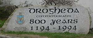
| First Charter | 1194 AD | ||
| County Status | 1412 AD[1](Abolished 1898) | ||
| Highest elevation | 23 m (75 ft) | ||
| Lowest elevation | 1 m (3 ft) | ||
| Population (Census 2011)[2] | |||
| • Rank | 6th | ||
| • Urban | 30,393 | ||
| • Rural | 8,185 | ||
| • Total | 38,578 (with environs) | ||
| Demonym(s) | Droghedean, Boynesider | ||
| Time zone | WET (UTC0) | ||
| • Summer (DST) | IST (UTC+1) | ||
| Irish Grid Reference | O088754 | ||
| Dialing code | +353 41 | ||
| Website |
drogheda | ||
Drogheda (/ˈdrɒhədə/; /ˈdrɔːdə/; Irish: Droichead Átha, meaning "bridge of the ford") is one of the oldest towns in Ireland, known for its tourism and as a centre of industry, and medical care. It is located in County Louth on the Dublin-Belfast corridor on the east coast of Ireland, 56 km (35 mi) north of Dublin. It is the last bridging point on the River Boyne before it enters the Irish Sea.The UNESCO World Heritage Site of Newgrange is located 8 km to west of the town.
As the River Boyne divides the dioceses of Armagh and Meath, Drogheda was founded as two separate towns, Drogheda-in-Meath (for which a charter was granted in 1194) and Drogheda-in-Oriel (or 'Uriel') as County Louth was then known. In 1412 these two towns were united and Drogheda became a 'County Corporate', styled as 'the County of the Town of Drogheda'. Drogheda continued as a County Borough until the setting up of County Councils, through the enactment of the Local Government (Ireland) Act 1898, which saw all of Drogheda, including a large area south of the Boyne, become part of an extended County Louth. With the passing of the County of Louth and Borough of Drogheda (Boundaries) Provisional Order, 1976, County Louth again grew larger at the expense of County Meath. The boundary was further altered in 1994 by the Local Government (Boundaries) (Town Elections) Regulations 1994. The 2007–2013 Meath County Development Plan recognises the Meath environs of Drogheda as a primary growth centre on a par with Navan.
In recent years Drogheda's economy has diversified from its traditional industries, with an increasing number of people employed in the retail, services and technology sectors. The town also has a community of independent artists and musicians who have been looking to the local economy rather than Dublin for employment.
Demographics
Drogheda has a hinterland of 70,000+ within a 15 kilometres (9.3 mi) radius covering County Louth and County Meath. According to the 2011 Irish Census, there are 30,393 in Drogheda town.[3]
| Electoral Division | Population |
|---|---|
| County Louth | |
| Drogheda Town | 30,393 |
| St Peters | 9,151 |
| Termonfeckin | 3,294 |
| Mullary | 1,723 |
| Monasterboice | 1,342 |
| TOTAL | 41,925 |
| County Meath | |
| Duleek | 5,177 |
| Grangegeeth | 594 |
| Julianstown | 9,606 |
| Killary | 502 |
| Melifont | 561 |
| Painstown | 1,175 |
| Slane | 1,861 |
| St Mary's (Part) | 10,769 |
| Stackallan | 4,696 |
| TOTAL | 31,557 |
History
Hinterland
| Historical population | ||
|---|---|---|
| Year | Pop. | ±% |
| 1813 | 16,123 | — |
| 1821 | 18,118 | +12.4% |
| 1831 | 17,365 | −4.2% |
| 1841 | 17,300 | −0.4% |
| 1851 | 16,810 | −2.8% |
| 1861 | 14,722 | −12.4% |
| 1871 | 13,510 | −8.2% |
| 1881 | 12,297 | −9.0% |
| 1891 | 11,873 | −3.4% |
| 1901 | 12,760 | +7.5% |
| 1911 | 12,501 | −2.0% |
| 1926 | 12,716 | +1.7% |
| 1936 | 14,494 | +14.0% |
| 1946 | 15,715 | +8.4% |
| 1951 | 16,779 | +6.8% |
| 1956 | 17,008 | +1.4% |
| 1961 | 17,085 | +0.5% |
| 1966 | 17,908 | +4.8% |
| 1971 | 20,095 | +12.2% |
| 1981 | 23,615 | +17.5% |
| 1986 | 24,681 | +4.5% |
| 1991 | 24,656 | −0.1% |
| 1996 | 25,282 | +2.5% |
| 2002 | 31,020 | +22.7% |
| 2006 | 35,090 | +13.1% |
| 2011 | 38,578 | +9.9% |
| 2016 | 42,347 | +9.8% |
| [4] | ||
The town is situated in an area with an abundance of archaeological monuments dating from the Neolithic period onwards, of which the large Passage Tombs of Newgrange, Knowth and Dowth are probably the best known.[5] The remarkable density of archaeological sites of the prehistoric and Early Christian periods uncovered in recent years in the course of development, notably during construction of the Northern Motorway: Gormanston to Monasterboice, or 'Drogheda Bypass', have shown that the hinterland of Drogheda has been a settled landscape for millennia.[6]
Town beginnings
Despite local tradition linking Millmount to Amergin Glúingel, in his 1978 study of the history and archaeology of the town, John Bradley stated that "neither the documentary nor the archaeological evidence indicates that there was any settlement at the town prior to the coming of the Normans".[7] The results of the numerous and often large-scale excavations carried out within the area of the medieval town in the past ten years appear to have confirmed this statement.[8]
The earliest monument in the town is the motte-and-bailey castle, now known as Millmount Fort, which overlooks the town from a bluff on the south bank of the Boyne, and which was probably erected by the Norman Lord of Meath, Hugh de Lacy sometime before 1186. The wall on the east side of Rosemary’s Lane is the oldest stone structure in Drogheda. [9]It was completed in 1234 as the west wall of the first castle guarding access to the northern crossing point of the Boyne. The earliest known town charter is that granted to Drogheda-in-Meath by Walter de lacy in 1194.[10] In the 1600s the name of the town was also spelled "Tredagh" in keeping with the common pronunciation, as documented by Gerard Boate in his work Irelands' Natural History.
Drogheda was an important walled town in the English Pale in the medieval period. It frequently hosted meetings of the Irish Parliament at that time. In a spill-over from the War of the Roses, according to R.J.Mitchell in John Tiptoft, Earl of Worcester, the Earl of Desmond and his two youngest sons (still children) were executed there on Valentine's Day, 1468, on orders of the Earl of Worcester, the Lord Deputy of Ireland. It later came to light (see Robert Fabyan, "The New Chronicles of England and France"), that the Queen herself was implicated in the orders given. The parliament was moved to the town in 1494 and passed Poynings' Law, the most significant legislation in Irish history, a year later. This effectively subordinated the Irish Parliament's legislative powers to the King and his English Council.
Later events
.jpg)
The town was besieged twice during the Irish Confederate Wars.
On the second occasion an assault was made on the town from the south, the tall walls breached, and the town was taken by Oliver Cromwell on 11 September 1649,[11] as part of the Cromwellian conquest of Ireland and it was the site of a massacre of the Royalist defenders. In his own words after the siege of Drogheda, "When they submitted, their officers were knocked on the head, and every tenth man of the soldiers killed and the rest shipped to Barbados."[12]
The Earldom of Drogheda was created in the Peerage of Ireland in 1661.
The Battle of the Boyne, 1690, occurred some 6 km (3.7 mi) west of the town, on the banks of the River Boyne, at Oldbridge.
In 1790 Drogheda Harbour Commissioners established, later Drogheda Port Company
In 1825 the Drogheda Steam Packet Company was formed in the town, providing shipping services to Liverpool.
In 1837 the population of Drogheda area was 17,365 of whom 15,138 lived in the town.[13]
Town arms
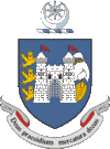
A Norman element on Drogheda's coat of arms is its centrepiece, St. Laurence's Gate. The three lions which flank the Norman barbican and the star and crescent are supposedly a reference to the seal of King John, who gave the town its charter. On the other side of the barbican is a ship denoting Drogheda's status as an important port. The town's motto Deus praesidium, mercatura decus translates as "God our strength, merchandise our glory".[14][15]
A local narrative has it that the star and crescent were included in the town arms after the Ottoman Empire sent financial aid and ships laden with food to Drogheda during the Great Famine.[16] There are no records of this with the Drogheda Port nor the Irish National Library, due to the fire that occurred in the 20th century. However, Newspaper articles from the period refer to three foreign ships sailing up the River Boyne in May 1847.[17]
20th century
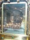
In 1921 the preserved severed head of Saint Oliver Plunkett, who was executed in London in 1681, was put on display in St. Peter's Church, where it remains today. The church is located on West Street, which is the main street in the town.
Industry and economy
- Boyne Valley Group, a manufacturer of Boyne Valley Honey, Chivers, Erin, McDonnells, Don Carlos
- Becton Dickinson (BD), manufacturer of medical equipment. IDA client.
- Coca-Cola International Services. IDA client
- State Street International Services IDA client
- Natures Best, a fresh food processor
- Yapstone Inc .European Headquarters. IDA client [18][19]
- Kelton Tech Solutions. IT company. IDA client.
- Drogheda Port Company, the oldest indigenous employer since 1790
- Glanbia, dairy products factory.
- Premier RHI AG, or Premier Periclase, produces Seawater Magnesia products at its plant – 115 employees
- Flogas, a national gas distributor
- M & L Manafucturing. Electronics
- Hilton Foods, a meat processor
- CRH plc, Irish Cement, Ireland's largest cement works at Platin.
- Bakehouse Biscuit Factory.
- Water Wipes . Baby Care Products.
- Boann Distillery and Brewery
- Dan Kellys Cider Brewery
Alcohol brewing and distilling
Drogheda has a long tradition of brewing and distilling with international companies Jameson Whiskey, Coca-Cola, Guinness, Jack Daniel's all having previously owned or are still currently producing their products in or just outside the town. Currently, Boann distillery and brewery manufacturers whiskey, gin, cider, and beer in the town. Slane Whiskey - A Jack Daniels owned company, distills whiskey just outside the town at Slane. Listoke House distills its own gin. Dan Kellys makes its own cider. Jack Codys manufactures craft beers and stouts. The town formerly distilled Prestons whiskey - a Jameson Whiskey brand, Carines Beer - founded locally and sold to Guinness, and Coca-Cola concentrate was also made in the town but has since moved to ballina, county Mayo.
Arts and entertainment
Theatre and performing arts
The town hosts an annual summer Samba festival, where Samba bands from around the world converge on the town for three days of drumming and parades.[20]
It is also home to the Calipo theatre company which specialises in multi-media productions and has achieved considerable success in Ireland and abroad.
The town also has the Droichead Youth Theatre.
The addition of the Little Duke Theatre company (Drogheda School of Performing Arts[21]) in Duke Street, in the old Julian Blinds building.
The Calipo Theatre was founded in 1994 in Drogheda by Darren and Colin Thornton, former members of Droichead Youth Theatre.
Upstate Theatre Project is a performing arts organisation located in Drogheda. The organisation was founded in 1997, by Declan Mallon, also co-founder of Droichead Youth Theatre.
The Municipal Centre in Stockwell Street acts as a base for most of the town's artists, under the umbrella of the Droichead Arts Centre, and featuring a gallery space and a theatre. The former Garda station in West Street is now a satellite site of the Droichead Arts Centre. This site is called Barlow House.
Drogheda also has a long tradition of its very own pantomime, which is usually held in January/February of each year. These productions have been going for roughly 60 years. Many locations have been used for staging productions, most notably the Barbican Theatre on the site of the old Parochial Centre.
Places of interest
Drogheda is an ancient town that enjoys a growing tourism industry. It has a UNESCO World Heritage site, Newgrange, located 8 kilometres (5.0 mi) to the west of the town centre.
- Millmount Fort and museum
- Saint Laurence Gate barbican gate c. 1300s
- Memorial to John Philip Holland, submarine inventor
- Boyne Viaduct,
- John Jameson's whiskey trail and malthouses,
- Battle Of The Boyne Site,visitors centre
- Eamonn Ceannt's school (formerly St Joseph's CBS now operates as Scholars Hotel.
- Clogherhead fishing village,
- St Patrick's Well Located at the Old Abbey
- Beaulieu House and gardens
- Mellifont Abbey,
- Townley Hall nature trail and woods,
- Slane Castle and village
Drogheda today
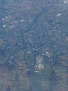
With the expansion of the Irish economy in the 1990s, during the "Celtic Tiger" years, Drogheda became one of the main secondary locations for people who work in Dublin to buy a house, as property prices in the capital became prohibitive for many first-time home buyers. This was aided by the expansion of transport infrastructure in the direction of Drogheda i.e. the Swords and Balbriggan bypasses, the Boyne River Bridge and the increased number of commuter trains serving the town. Partly as a result, the downtown area of Drogheda has redeveloped, and two large shopping centres have opened, while several national and international retailers have opened stores. In 2007 the partial pedestrianisation of the town's main street, West Street, was completed. On the south quay in the space of the former Lakeland Dairies premises (an old industrial area), the Scotch Hall Shopping Centre and the D Hotel was completed in November 2005. A new pedestrian bridge extends from the north quay, at Mayoralty Street, into the complex. Phase Two of the development, which will shortly commence construction, will extend further down along the river front, on the site of the former Irish Oil Cake works. It will have an extension to the shopping centre and hotel, new apartments, cinema, and a riverside plaza. There is many schools
Transport, communications and amenities

Road links and infrastructure
Drogheda is located close to the M1 (E1 Euro Route 1) (main Dublin – Belfast motorway). The Boyne River Bridge carries traffic from the M1, across the River Boyne, 3 km west of the town. It was opened on 9 June 2003 and is the longest cable-stayed bridge in Ireland. The town's postcode, or eircode, is A92.
Railway
Drogheda acquired rail links to Dublin in 1844, Navan in 1850 and Belfast in 1852. Passenger services between Drogheda and Navan were ended in 1958, however the line remains open for freight (Tara Mines/Platin Cement) traffic. In 1966 Drogheda station was renamed "MacBride". Drogheda railway station opened on 25 May 1844.[22]
The station has direct trains on the Enterprise northbound to Dundalk, Newry, Portadown, Lisburn and Belfast Central, and southbound to Dublin Connolly.
A wide variety of Irish Rail commuter services connect southbound to Balbriggan, Malahide, Howth Junction, Dublin Connolly, Tara Street, Dublin Pearse, Grand Canal Dock, Dún Laoghaire, Bray, Greystones, Wicklow, Rathdrum and Arklow.
Bus transport
Drogheda's bus station is located on the Donore Road and a comprises waiting area, information office and toilets. It replaces an earlier facility on the Bull Ring.
As well as a town service, route 173, several local routes radiate from Drogheda and a number of these have had their frequency increased in recent years. Local routes include: 100 (Newry/Dundalk via Dunleer), 100X (Dundalk-Dublin Airport-Dublin), 101 (Julianstown-Balbriggan-Dublin), 163 (Brú na Bóinne via Donore), 182/A (Monaghan via Ardee and Tullyallen), 189/A (Ashbourne via Duleek and Clogherhead/Grangebellew via Baltray & Termonfeckin), 190/A (Laytown via Mornington & Bettystown and Trim/Athboy via Slane & Navan).[23]
On Friday and Saturday nights there is also a Night bus service, route 101N operated by Bus Éireann (Dublin-Dublin Airport-Balbriggan-Drogheda) and return.
Matthews Coaches also operate a Dundalk to Dublin route serving the town.[24]
Past Bus Éireann routes included the 184 to Garristown and 185 to Bellewstown but these were discontinued a few years ago.
Bridges
Defined by its location as the last crossing point on the Boyne before it reaches the sea, Drogheda has seven bridges in its vicinity.
Politics and government
| Drogheda Borough District members from the 2014 local elections | |||
|---|---|---|---|
| Local electoral area | Name | Party | |
| Drogheda | Imelda Munster | Sinn Féin | |
| Paul Bell | Labour Party | ||
| Alan Cassidy | Sinn Féin | ||
| Tommy Byrne | Fianna Fáil | ||
| Kevin Callan | Independent | ||
| Oliver Tully | Fine Gael | ||
| Frank Godfrey | Independent | ||
| Richie Culhane | Fine Gael | ||
| Pio Smith | Labour Party | ||
| Kenneth Flood | Sinn Féin | ||
Drogheda Borough Council is an elected local government body which is mandated under the Local Government Act 2001 to provide civic leadership and a forum for the democratic representation of the community. Responsibilities include amenity support, operation of the Litter Act, contribution to tourism development, event licensing, arts support, etc. The Borough Council executive comprises twelve elected Councillors, headed by the mayor. The current mayor is Richard Culhane (Fine Gael).[25]
For local elections to Louth County Council, the town forms part of two local electoral areas – Drogheda East (6) and Drogheda West (4) . This includes both the urban Drogheda area and surrounding rural areas.
For the purposes of elections to Dáil Éireann, the town is part of the five seat Louth constituency which returns five TDs. Following the 2011 general election, the constituency elected two TDs for the Fine Gael party (centre right), and one TD each for Fianna Fáil (centre to centre-right), the Labour Party (centre left) and Sinn Féin (left wing).
Shopping
Shopping mostly takes place in the medieval streeted historic quarter of the town, where the main shopping streets are West Street, Shop Street, Peter Street, and Laurence Street . West Street is the main street and is known as the 'Golden Quarter Mile', it is home to large and small retail shops and several cafes and restaurants. The town centre has five shopping centres, Scotch Hall, Laurence Town Centre, Drogheda Shopping Centre, Abbey Shopping Centre, and Boyne Shopping Centre. An out of town shopping centre Souhtgate is located at the southern entrance to the town. A number of retail parks have been developed around Drogheda since the year 2000, mainly on the southern and western side of the town. On the northside, is the M1 Retail Park and on the south side is the Drogheda Retail Park.

Media
The local newspapers are The Drogheda Independent and The Drogheda Leader, known locally as The D.I. and The Leader. Both newspapers are published every Wednesday. The Leader a free-of-charge newspaper has a circulation of 24,000 and the Drogheda Independent's circulation is 6,850 (2011 ABC). The headquarters of The Drogheda Independent are on Shop Street and The Drogheda Leader's offices are on Laurence Street.
The local radio station is LMFM, broadcasting on 95.8 FM. The headquarters of LMFM are on Marley's Lane on the south side of the town.
Hospitals and health care
Drogheda is a regional centre for medical care. Its main hospital is Our Lady of Lourdes Hospital, a public hospital located in the town. and is part of the Louth Meath Hospital Group. It is managed by the Irish Government's Health Service Executive (HSE) and provides acute-care hospital services, including a 24-hour emergency department for the populations of County Louth, County Meath and the entire North-East of Ireland. The hospital provides 340 beds, of which 30 are reserved for acute day cases. [26]
Education
The are currently six secondary schools situated in Drogheda. Saint Joseph secondary school in Newfoundwell is an all boy school. Saint Marys diocesan school situated in Beamore road which is an all boys school. Sacred heart school which is situated in Sunnyside Drogheda which is an all girls school. Drogheda Grammar school which is situated on Mornington road and is a mixed school. Saint Oliver's community college[27] which is situated on Rathmullen road and is a mixed school. Our lady's college which is an all girl school is situated in Greenhills. Drogheda institute for further education(DIFFE) is a third level college situated in Moneymore
Sport
- Football: In December 2005 the town's soccer team, Drogheda United, won the FAI Cup for the first time. In 2006 Drogheda United won the Setanta Cup. In 2007, Drogheda United won the League of Ireland for the first time in the club's history. Drogheda United FC's brother team is Trabzonspor from Turkey. Both of two team's colours are claret red and blue.
- Rugby: Local team Boyne RFC was formed in 1997 from the amalgamation of Delvin RFC and Drogheda RFC. As of 2010, the Men's 1st XV team plays in the Leinster J1 1st division. Drogheda is also home to many rugby playing schools, including St.Mary's who are the under 14 Leinster rugby champions.
- Gaelic Football: There are 5 clubs in Drogheda. Newtown Blues GFC, Wolfe Tones GFC, O'Raghallaigh's, Oliver Plunket's GFC, St. Nicholas's GFC.
Town twinning
-
 – Bronte, Catania, Italy
 -
 – Salinas, California, United States
 -
 - Eastwood, Nottingham, United Kingdom
People
Drogheda has a long list of famous citizens. It also has several famous residents who were born in the town but raised elsewhere, and other noted residents that were born elsewhere but came to live in Drogheda.
General
- Yasmine Akram, comedian and actress in Sherlock (TV series)
- Pierce Brosnan, actor, film producer and environmentalist. Born in Drogheda, Grew up in Navan.
- Tommy Byrne, former racing driver, raced briefly in Formula 1 in 1982
- Tony Byrne, bronze medal winner for Ireland 1956 Summer Olympics in Melbourne in the lightweight division.
- Eamonn Campbell, member of The Dubliners
- Alan Thomas Cairnes Governor Bank of Ireland [28]
- Eamonn Ceannt 1916 Rising Leader - secondary school student in St Joseph CBS Drogheda.
- James Cullen, mathematician who discovered what are now known as the Cullen numbers.
- Sir Oscar Bedford Daly, Lord Chief Justice of the Bahamas.
- Frank Thornton, Commanding Officer in Liberty Hall and Imperial Hotel during 1916 Rising in Dublin.
- Deirdre Gogarty, 1997 Women's International Boxing Federation (WIBF) Featherweight Title Champion.
- Angela Greene, poet, Patrick Kavanagh Award 1988, Salmon Press.
- John Philip Holland, inventor of the modern day submarine.
- Michael Holohan, composer and member of Aosdána
- William Hughes, Irish-born US senator from New Jersey.
- Sir William Scarlett Jameson, Rear Admiral HMS Royal Ark (chief engineer).[29]
- Alison Kelly (diplomat), Irish ambassador to Israel.
- Jonathan Kelly, singer-songwriter.
- Courtney Love singer actress and wife of Kurt Cobain [30] [31]
- William Kenny, recipient of the Victoria Cross
- Thomas Lancaster, bishop, buried at St. Peter's Church.
- Tony Martin, Canadian social democratic legislator.
- Jill Meagher, crime victim.
- Colin O'Donoghue, actor known for his role of Captain Hook/Killian Jones in the American TV Show Once Upon a Time.
- Eliza O'Neill, actress.
- Sir Patrick Branigan, Human rights lawyer that drafted the constitution of Malta and Ghana. Ghana's first Justice Minister
- John Boyle O'Reilly, poet and novelist, member of the Irish Republican Brotherhood
- Nano Reid, painter of landscapes, particularly Drogheda, the Boyne Valley and surrounding areas.
- Michael Scott, architect who designed Busáras and the Abbey Theatre
- Henry Singleton, judge and friend of Jonathan Swift, was a lifelong resident of Drogheda.
- Des Smyth, professional golfer, vice-captain on the winning Ryder Cup team in 2006.
- Fiachra Trench, Composer. Penned the string arrangement for fairytale of New York wrote music for many Hollywood movies.
- T. K. Whitaker, former Irish economist who wrote the Programme for Economic Expansion [32]
- Sir John Lumsden, founder of St John Ambulance Ireland
- Thomas McLaughlin ESB founder and first CEO. Built the Shannon Hydro Electric Plant.
- Thomas Wright Officer in Simon Bolivar's army and Commander of the Ecuadorian Navy. [33] [34]
International Soccer players
- Tommy Breen, Manchester United goalkeeper
- Megan Campbell, Manchester City Left Back
- Jerome Clarke, former Drogheda United forward, earned one cap for the Republic of Ireland.
- Nick Colgan, goalkeeper for Chelsea F.C., Hibernian F.C. and the Republic of Ireland.
- Barry Conlon, former Manchester City Striker
- James Hand, footballer Sheffield United
- Ian Harte, full-back for Reading F.C. former Blackpool F.C, Leeds United, Levante (Spain) & Sunderland player and the Republic of Ireland.
- Gary Kelly, football player and charity campaigner.
- David McAllister, midfielder Huddersfield Town
- Steve Staunton, former Liverpool F.C and Aston Villa player was born there.
- Kevin Thornton, midfielder Coventry City F.C. and former Republic of Ireland under 21.
- Sean Thornton, midfielder Drogheda United and former Republic of Ireland under 21 national team.
See also
- The Thorn Birds, a 1977 novel by Colleen McCullough
- List of abbeys and priories in Ireland (County Louth)
- List of towns and villages in Ireland
References
- ↑ Johnston, L. C. (1826). History of Drogheda: from the earliest period to the present time. Drogheda. p. 37.
- ↑ "Latest News". Airo.ie. Retrieved 20 November 2014.
- ↑ http://www.boundarycommittee.ie/reports/2013-Report.pdf
- ↑ See www.cso.ie/census and www.histpop.org for post 1821 figures, 1813 estimate from Mason's Statistical Survey. For a discussion on the accuracy of pre-famine census returns see J.J. Lee "On the accuracy of the Pre-famine Irish censuses", Irish Population, Economy and Society, eds. J.M. Goldstrom and L.A. Clarkson (1981) p.54, and also "New Developments in Irish Population History, 1700–1850" by Joel Mokyr and Cormac O Grada in The Economic History Review, New Series, Vol. 37, No. 4 (Nov. 1984), pp. 473–488.
- ↑ Stout, G. 2002 Newgrange and the Bend of the Boyne. Cork University Press.
- ↑ Bennett, I. (ed) 1987–2004 Excavations : Summary accounts of archaeological excavations in Ireland. Bray.
- ↑ Bradley, J. 1978 'The Topography and Layout of Medieval Drogheda', Co. Louth Archaeological and Historical Journal, 19, 2, 98–127.
- ↑ Bennett op cit.
- ↑ Archaeology No. 5257: The medieval walls of Drogheda
- ↑ Bradley op cit 105
- ↑ Antonia Fraser, Cromwell, our chief of men (London, 1973)
- ↑ Cromwell letter to William Lenthall (1649)
- ↑ "Entry for Drogheda in Lewis Topographical Dictionary of Ireland (1837)". Libraryireland.com. Retrieved 20 November 2014.
- ↑ "Heraldry of the world - Outdated file". Ngw.nl. Retrieved 20 November 2014. "The star and crescent are the royal seal of King John, who gave the town its charter."
- ↑ Murray, Ken (25 March 2010). "President tells Turks an anecdote of myth not fact". The Irish Times. Retrieved 25 March 2010. "Liam Reilly, an administrator with the Old Drogheda Society based in the town’s Millmount Museum, said last night the comments were incorrect. 'There are no records with the Drogheda Port Authority of this ever happening. Drogheda historians can trace the star and crescent back to 1210 when the British governor of Ireland, King John Lackland, granted the town its first charter,' he said."
- ↑ "Ottoman aid to the Irish to hit the big screen". TodaysZaman. Retrieved 20 November 2014.
- ↑ "New evidence shows Turkey delivered food to Ireland during the famine". IrishCentral.com. Retrieved 20 November 2014.
- ↑ http://www.yapstone.com/contact/
- ↑ http://www.businesswire.com/news/home/20150413005192/en/YapStone-Names-Daniel-Issen-Chief-Technology-Officer
- ↑ Noel Cosgrave. "Drogheda Samba Festival". Droghedasamba.com. Retrieved 20 November 2014.
- ↑ "Little Duke Theatre". Littleduketheatre.com. Retrieved 20 November 2014.
- ↑ "Drogheda station" (PDF). Railscot – Irish Railways. Retrieved 5 September 2007.
- ↑ "Bus timetable : Louth". buseireann.ie. Retrieved 20 November 2014.
- ↑ "Matthews Coach Hire - Coach Tours, Corporate Hire, Private Coach Hire, Commuter Service Dublin Drogheda Dundalk". Matthews.ie. Retrieved 20 November 2014.
- ↑ "Ex GAA star Richie is new mayor of town". Irish Independent. Retrieved 20 November 2014.
- ↑ http://www.hse.ie/eng/services/list/3/acutehospitals/hospitals/Lourdes/
- ↑ Saint Oliver's community college
- ↑ http://www.thepeerage.com/p36002.htm
- ↑ http://www.famousjamesons.com/familygroup.php?familyID=F200&tree=Whiskey_Jamesons
- ↑ http://www.independent.ie/entertainment/love-story-courtney-love-26652337.html
- ↑ http://www.irishtimes.com/culture/music/2.681/i-ve-been-tortured-and-scorned-since-the-day-i-was-born-1.662130
- ↑ http://www.independent.ie/regionals/droghedaindependent/localnotes/tk-whitaker-recalls-his-childhood-in-paradise-27109582.html
- ↑ http://www.independent.ie/regionals/droghedaindependent/lifestyle/time-to-honour-the-great-thomas-wright-30612377.html
- ↑ http://www.irishships.com/famous_irish_mariners.html
Further reading
- Quane, Michael (1963). "Drogheda Grammar School". Journal of the County Louth Archaeological Society. 15 (3): 207–248. doi:10.2307/27729054. JSTOR 27729054. (subscription required (help)).
External links
| Wikivoyage has a travel guide for Drogheda. |
| Wikimedia Commons has media related to Drogheda. |
 "Drogheda". Encyclopædia Britannica. 8 (11th ed.). 1911.
- Drogheda Borough Council
- Drogheda Port
- Drogheda on the Boyne – Official Tourism Website
- Drogheda & District Chamber of Commerce
- http://www.stmarysds.ie/
