Julianstown
| Julianstown Baile Iúiliáin | |
|---|---|
| Town | |
 Julianstown Location in Ireland | |
| Coordinates: 53°40′13″N 6°16′49″W / 53.670222°N 6.280191°WCoordinates: 53°40′13″N 6°16′49″W / 53.670222°N 6.280191°W | |
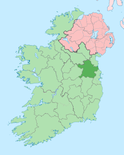
| Country | Ireland |
| Province | Leinster |
| County | County Meath |
| Elevation | 0 m (0 ft) |
| Time zone | WET (UTC+0) |
| • Summer (DST) | IST (WEST) (UTC-1) |
| Irish Grid Reference | O162714 |
| Website |
www |
Julianstown (Irish: Baile Iúiliáin) is a village in County Meath, Ireland. It is located near Drogheda on the R132 regional road not far from the Mosney Camp. In 1641, the battle of Julianstown was fought here during the Irish Rebellion of 1641
Julianstown is situated on the River Nanny which flows into the sea at Laytown, about 3 km away. It has a strong community with both Roman Catholic and Church of Ireland churches, a National Primary school and a public house.
Origins
Julianstown is significant in that it contains a bridge across the river Nanny on the road between Dublin and Belfast.[1] One of the earliest mentions of Julianstown commemorates the Battle of Julianstown in 1641, which took place near the bridge. Indeed, there is a commemorative plaque on the bridge erected by Billy Butlin in the 1960s
Julianstown was the seat of the Moore family who lived in Julianstown house and occupied the land that now contains the townland of Julianstown West. Taylor and Skinner’s 1783 Road Map of Ireland refers to the Moore seat and also shows the Church of Ireland Church which still stands today. There is little evidence of any other habitation at that time. Taylor and Skinner also show the milestone in the centre of the village marking 20 Irish miles to Dublin. This milestone can still be seen today. There is further mention of William Moore in Lewis' Topographical Dictionary of Ireland (1837).
The Moores leased the land from Anglo-Irish landlords, including Anna Disney, the wife of Brabazon William Disney, Dean of Armagh. The land on which the present village sits was leased to Francis and Mary Thornburgh (née Moore) in 1763 by William Moore. In the lease the land was described as
….. all that dwelling house offices orchard and garden thereunto adjoining known by the name of the Blackhorse Head Inn situate near Julianstown Bridge aforesaid together with the piece of parcel of ground opposite said house containing by common estimation 300 feet in length and 73 feet in depth more or less formerly known by the name of the Malt House bounded on the East by the Turnpike Road and on the North by the said William Moore’s ground adjoining the lands called the Corroge with two cabins or tenements standing thereon all of which lands and premises are situate in the Barony of Duleek and County of Meath.
The land was further subleased to Colonel Charles Pepper of nearby Ballygarth Castle in 1801. In 1856 Pepper made his lease perpetual under legislation of the time and around 1889 built the cottages that can be seen in the village today.
An important part of Julianstown heritage is the history of milling. In the 19th century fourteen mills operated along the Nanny either flax or cornmills. [2]The village became inhabited in the early 19th century and in 1869 a forge was established by Bartholomew Tiernan on land adjacent to the Nanny River, some of his metalwork, commissioned for the cottages can still be seen to this day in Julianstown. Indeed, in the past Julianstown had a Dispensary, Courthouse, telephone exchange, a shop, a quarry, a lime kiln and a Garda Barracks.
Julianstown Today
Julianstown, in line with much of Eastern Ireland and Bettystown in particular has become a popular location for commuters to Dublin, Drogheda and Dundalk. This has resulted in a large influx in new housing developments to the north and south fringes of the village. The construction of a new sewage treatment works near the Old Kiln to address the increased demand was vehemently opposed by local residents, who felt that the aesthetics of the village would be affected. The treatment works were however completed in late 2004.
The R132 was until recently the main Dublin to Belfast road and it runs through the centre of Julianstown. Despite the completion of the M1 motorway the volume of traffic on the R132 has continued to increase. Traffic lights have been installed in the village.
The village shop ceased trading in 1995.
After more than a century the village post office was closed due to the retirement of the post mistress, although the contract was advertised on three occasions there has been no interest in the operation of a post office in the village.
Continuing the decline of Julianstown, the Old Mill Hotel was closed and put up for sale in mid-2007. Shortly before it was sold it was destroyed by fire. There was another fire in the thatch of the Julianstown Inn on Sunday 20 April 2008. Thankfully the fire was quickly brought under control, and the damage to the pub was not extensive. The bar reopened several days later but the lounge remains closed.
Village Design
Julianstown has been selected as the first pilot village for the new program of Village Design Statements in Ireland. This project which started in September 2009 was the culmination of three years work by members of Julianstown and District Residents' Association and arose out of its relationship with the Heritage Council. In October 2008, JDRA made a presentation to the national village design conference held in Slane Castle on the topic: "Why Julianstown Wants and Needs a VDS". The residents produced an innovative presentation and drama to represent the motivation and needs driving their desire to produce a VDS for Julianstown.
The Heritage Council funded a DVD production of the presentation which was shown to Minister for the Environment, John Gormley who personally endorsed Julianstown's VDS plans. The project also has full backing and support of the local authority, Meath County Council.
Following this, Julianstown was selected by the Heritage Council to be the first pilot. A subgroup was established in the community and the process commenced when the Paul Hogarth company were successful in winning the tender to act as professional consultants to the project. Over the next 12 months or so a series of workshops and training events will be held in order to gather the information needed to produce the VDS which it is envisaged will be incorporate in the statutory planning framework for Julianstown.
Julianstown Traffic
Julianstown has chronic levels of traffic. More than 22,000 vehicles per day go through the village. At peak times there are over 1750 vehicles per hour, and in the morning rush hour traffic levels exceed those on the M1 motorway which Meath County Council maintains is a bypass for Julianstown. Indeed, traffic in Julianstown is at two thirds the motorway level. The local authority has only recently installed traffic lights, which help greatly whilst crossing the busy road.
Recently the local authority published a noise map which shows traffic noise in the village exceeding levels which cause harm to human health and which impair the learning capacity of children.
See also
References
External links
- Traffic Volumes in Julianstown (2006 to date)
- Traffic Volumes in Julianstown (1997 to 2006)
- Entry in Lewis Topographical Dictionary of Ireland
- National Village Design Statement Conference 2008
- Julianstown and District Residents' Association presentations
Photos
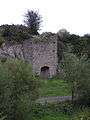 An old lime kiln near the town.
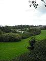 View of the River Nanny
 Brightly painted houses in Julianstown
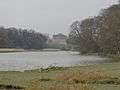 Ballygarth Castle
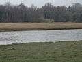 River Nanny from Sonairte
 Julianstown Inn Fire
 Julianstown Inn Fire
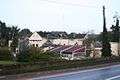 Old Mill Hotel gutted by fire
 Old Mill Hotel gutted by fire