Durham, England
| Durham City of Durham | |||
|---|---|---|---|
| City and non-metropolitan district | |||
|
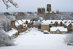
Durham Cathedral and Castle above the River Wear | |||
| |||
| Motto: Faith, foresight, and industry. | |||
 Durham Shown within County Durham | |||
| Coordinates: 54°46′34″N 1°34′24″W / 54.7761°N 1.5733°WCoordinates: 54°46′34″N 1°34′24″W / 54.7761°N 1.5733°W | |||
| Sovereign state |
| ||
| Constituent country |
| ||
| Region | North East England | ||
| Ceremonial county |
| ||
| Admin HQ | County Hall, Durham | ||
| Founded | AD 995 | ||
| City Status | 1974 | ||
| Government | |||
| • Type | City | ||
| • Governing body | Durham County Council | ||
| • Leader | Simon Henig | ||
| Area[1] | |||
| • Total | 186.68 km2 (72.08 sq mi) | ||
| Population (2011) | |||
| • Total | 50,000 | ||
| • Density | 257/km2 (670/sq mi) | ||
| Demonym(s) | Dunelmian | ||
| Postcode | DH1, DH6, DH7, DH8 | ||
| Area code(s) | 0191 | ||
| Website |
www | ||


Durham (/ˈdʌrəm/, locally /ˈdɜːrəm/) is a historic city and the county town of County Durham in North East England. The city lies on the River Wear, to the west of Sunderland, south of Newcastle upon Tyne and to the north of Darlington. Founded over the final resting place of St Cuthbert, its Norman cathedral became a centre of pilgrimage in medieval England. The cathedral and adjacent 11th-century castle were designated a World Heritage Site by UNESCO in 1986. The castle has been the home of Durham University since 1832. HM Prison Durham is also located close to the city centre.
Name
The name "Durham" comes from the Celtic element "dun", signifying a hill fort, and the Old Norse "holme", which translates to island.[2] The Lord Bishop of Durham takes a Latin variation of the city's name in his official signature, which is signed "N. Dunelm".[2] Some attribute the city's name to the legend of the Dun Cow and the milkmaid who in legend guided the monks of Lindisfarne carrying the body of Saint Cuthbert to the site of the present city in 995 AD.[3] Dun Cow Lane is said to be one of the first streets in Durham, being directly to the east of Durham Cathedral and taking its name from a depiction of the city's founding etched in masonry on the south side of the cathedral.[3] The city has been known by a number of names throughout history. The original Nordic Dun Holm was changed to Duresme by the Normans and was known in Latin as Dunelm. The modern form Durham came into use later in the city's history. The north eastern historian Robert Surtees chronicled the name changes in his History and Antiquities of the County Palatine of Durham but states that it is an "impossibility" to tell when the city's modern name came into being.[2]
History
Early history
Archeological evidence suggests a history of settlement in the area since roughly 2000 BC.[2] The present city can clearly be traced back to AD 995, when a group of monks from Lindisfarne chose the strategic high peninsula as a place to settle with the body of Saint Cuthbert, that had previously lain in Chester-le-Street, founding a church there.[3]
Legend of the Dun Cow and city origins
Local legend states that the city was founded in A.D. 995 by divine intervention. The 12th century chronicler Symeon of Durham recounts that after wandering in the north, Saint Cuthbert's bier miraculously came to a halt at the hill of Warden Law and, despite the effort of the congregation, would not move.[4] Aldhun, Bishop of Chester-le-Street and leader of the order, decreed a holy fast of three days, accompanied by prayers to the saint.[5] During the fast, Saint Cuthbert appeared to a certain monk named Eadmer, with instructions that the coffin should be taken to Dun Holm.[5] After Eadmer's revelation, Aldhun found that he was able to move the bier, but did not know where Dun Holm was.[5]
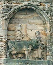
The legend of the Dun Cow, which is first documented in The Rites of Durham, an anonymous account about the Durham Cathedral, published in 1593, builds on Symeon's account.[6] According to this legend, by chance later that day, the monks came across a milkmaid at Mount Joy (southeast of present-day Durham). She stated that she was seeking her lost dun cow, which she had last seen at Dun Holm. The monks, realising that this was a sign from the saint, followed her.[5] They settled at a wooded "hill-island" – a high wooded rock surrounded on three sides by the River Wear.[5] There they erected a shelter for the relics, on the spot where the Durham Cathedral would later stand.[5] Symeon states that a modest wooden building erected there shortly later was the first building in the city.[4] Bishop Aldhun subsequently had a stone church built, which was dedicated in September 998.[7] It no longer remains, having been supplanted by the Norman structure.
The legend is interpreted by a Victorian relief stone carving on the south face of the cathedral and, more recently, by the bronze sculpture 'Durham Cow' (1997, Andrew Burton), which reclines by the River Wear in view of the cathedral.
Medieval history

During the medieval period the city gained spiritual prominence as the final resting place of Saint Cuthbert and Saint Bede the Venerable. The shrine of Saint Cuthbert, situated behind the High Altar of Durham Cathedral, was the most important religious site in England until the martyrdom of St Thomas Becket at Canterbury in 1170.[3]
Saint Cuthbert became famed for two reasons. Firstly, the miraculous healing powers he had displayed in life continued after his death, with many stories of those visiting the saint's shrine being cured of all manner of diseases. This led to him being known as the "wonder worker of England".[3] Secondly, after the first translation of his relics in 698 AD, his body was found to be incorruptible.[8] Apart from a brief translation back to Holy Island during the Norman Invasion[9] the saint's relics have remained enshrined to the present day.[10] Saint Bede's bones are also entombed in the cathedral, and these also drew medieval pilgrims to the city.[3]
Durham's geographical position has always given it an important place in the defence of England against the Scots.[11] The city played an important part in the defence of the north, and Durham Castle is the only Norman castle keep never to have suffered a breach.[12] The Battle of Neville's Cross, which took place near the city on 17 October 1346 between the English and Scots, is the most famous battle of the age.[2]
The city suffered from plague outbreaks in 1544, 1589 and 1598.
Prince Bishops
Owing to the divine providence evidenced in the city's legendary founding, the Bishop of Durham has always enjoyed the title "Bishop by Divine Providence"[13] as opposed to other bishops, who are "Bishop by Divine Permission".[2] However, as the north-east of England lay so far from Westminster, the bishops of Durham enjoyed extraordinary powers such as the ability to hold their own parliament,[2] raise their own armies,[3] appoint their own sheriffs and Justices, administer their own laws, levy taxes and customs duties, create fairs and markets, issue charters,[4] salvage shipwrecks, collect revenue from mines, administer the forests and mint their own coins.[2] So far-reaching were the bishop's powers that the steward of Bishop Antony Bek commented in 1299 AD: "There are two kings in England, namely the Lord King of England, wearing a crown in sign of his regality and the Lord Bishop of Durham wearing a mitre in place of a crown, in sign of his regality in the diocese of Durham".[14] All this activity was administered from the castle and buildings surrounding the Palace Green.[3] Many of the original buildings associated with these functions of the county palatine survive on the peninsula.[11]
Every Bishop of Durham from 1071 to 1836 was a Prince Bishop except for the first Norman appointment, Bishop Walcher (in office ca. 1071-1080), who was styled an Earl-Bishop.[2] Although the term "prince bishop" has been used as a helpful tool in the understanding the functions of the Bishops of Durham it is not a title they would have recognised.[3] The last Prince Bishop of Durham, Bishop William Van Mildert,[3] is credited with the foundation of Durham University in 1832. Henry VIII curtailed some of the Prince-Bishop's powers and, in 1538, ordered the destruction of the shrine of Saint Cuthbert.[3]
Legal system
The Prince Bishops also had their own court system, most notably the Court of Chancery of the County Palatine of Durham and Sadberge.[15] The county also had its own attorney general,[11] whose authority to bring an indictment for criminal matters was tested by central government in the case of R v Mary Ann Cotton (1873).[16] Certain courts and judicial posts for the county were abolished by the Supreme Court of Judicature Act 1873. Others were abolished by section 2 of the Durham (County Palatine) Act 1836 and section 41 of the Courts Act 1971.
Civil War and Commonwealth (1640 to 1660)
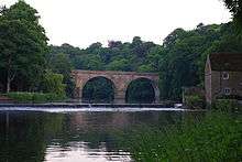
.jpg)
The city remained loyal to King Charles I throughout the English Civil War. Charles I came to Durham twice during his reign. Firstly, he came to the cathedral for a majestic service in which he was entertained by the Chapter and Bishop at great expense at the start of his reign. His second visitation to the city came towards the end of the civil war, escaping from the city as Oliver Cromwell's forces got closer.[17] Local legend
[18] stated he escaped down the Bailey and through Old Elvet. Another local legend has it that Cromwell stayed in a room in the present Royal County Hotel on Old Elvet during the civil war.[17] The room is reputed to be haunted by his ghost.[19] Durham suffered greatly during the civil war and Commonwealth. This was not due to direct assault by Cromwell but the abolition of the Church of England[18] and the closure of religious institutions pertaining to it. The city has always relied upon the Dean and Chapter and cathedral as an economic force.
The castle suffered considerable damage and dilapidation during the Commonwealth due to the abolition of the office of bishop whose residence it was. Cromwell confiscated the castle and sold it to the Lord Mayor of London shortly after taking it from the bishop.[17] A similar fate befell the cathedral, it being closed in 1650 and used to incarcerate 3,000 Scottish prisoners.[17] Graffiti left by them can still be seen today etched into the interior stone.[20]
At the Restoration in 1660, John Cosin (a former canon) was appointed bishop and set about a major restoration project. This included the commissioning of the famous elaborate woodwork in the cathedral choir, the font cover and the Black Staircase in the castle.[21] Other renovations were carried out to both the city and cathedral by his successor Bishop Lord Nathaniel Crewe.
18th century

In 1720 it was proposed that Durham could become a sea port by digging a canal north to join the River Team, a tributary of the River Tyne near Gateshead. Nothing came of the plan, but the statue of Neptune in the Market Place was a constant reminder of Durham's maritime possibilities.[22]
The thought of ships docking at the Sands or Millburngate remained fresh in the minds of Durham businessmen. In 1759, a new proposal hoped to make the Wear navigable from Durham to Sunderland by altering the river's course, but the increasing size of ships made this impractical. This was further compounded by the fact Sunderland had grown as the north east's main port and centre for shipping.[23]
The 18th century also saw the rise of the trade union movement in the city.
19th century
The Great Reform Act 1832 saw the removal of the Prince Bishop's powers,[24] although he still has the right to a seat in the House of Lords[25] and is regarded as the second most senior bishop and fourth most senior clergyman in the Church of England.[26] The Court of Claims of 1953 granted the traditional right of the bishop to accompany the sovereign at the coronation,[27] reflecting his seniority.[3]
The first census, conducted in 1801,[28] states that Durham City had a population of 7,100. The Industrial Revolution mostly passed the city by. However, the city was well known for carpet making and weaving. Although most of the mediaeval weavers who thrived in the city had left by the 19th century, the city was the home of Hugh MacKay Carpets’ factory, which produced the famous brands of axminster and tufted carpets until the factory went into administration in April 2005.[29] Other important industries were the manufacture of mustard and coal extraction.[30]
The Industrial Revolution also placed the city at the heart of the coalfields,[31] the county's main industry until the 1970s. Practically every village around the city had a coal mine and, although these have since disappeared as part of the regional decline in heavy industry, the traditions, heritage and community spirit are still evident. The city also saw the creation of the world's first passenger railway in 1825.[32]
The 19th century also saw the founding of Durham University[33] thanks to the benevolence of Bishop William Van Mildert and the Chapter in 1832. Durham Castle became the first college[30] (University College, Durham) and the bishop moved to Auckland Castle as his only residence in the county.
The first Durham Miners' Gala was attended by 5,000 miners in 1871 in Wharton Park,[34] and remains the largest socialist trade union event in the world.[30]
20th Century
During the 20th century the University expanded greatly. St John's College and St Cuthbert's Society were founded on the Bailey, completing the series of colleges in that area of the city. From the early 1950s to early 1970s Trevelyan, Van Mildert, Collingwood and Grey colleges were established to the south of the city, adjacent to new buildings for St Aidan's and St Mary's colleges for women, formerly housed on the Bailey. The final 20th century collegiate addition came from the merger of the independent nineteenth-century colleges of the Venerable Bede and St Hild, which joined the university in 1979 as the College of St Hild and St Bede.[35] Other significant university expansions at this time include the Elvet Riverside and Dunelm House buildings on New Elvet, the building of the Maiden Castle sports complex adjacent to the Iron Age fort of the same name, and the development of what would become the university's main science buildings on South Road, beginning in 1924.[35]
During World War II it was believed Durham might have become a target for the Baedeker raids, German attacks on historic British cities as retaliation for the bombing of Lübeck.[34] On the 29th April/ 1 May 1942 the Luftwaffe did indeed enter County Durham and may have been targeting the city, although what actually happened on that night has become something of a local legend. One account is that 'a mist, descending over the City like a ghostly shroud, hiding every building, as if they had disappeared', created by St Cuthbert, obscured the city sufficiently that the German bombers could not complete their task. Later it was linked to a tale recounted by Symeon of Durham regarding a similar mist sent by Cuthbert to thwart William the Conqueror, adding legitimacy to the tale for those who believed it. However it was noted by the chief ARP warden on duty that night that mist is common in Durham, often rising from the river, and that it failed to cover the cathedral's central tower that night.[34][36] Regardless of its truth the legend has continued to feature in the folklore of the city, including inspiring the artwork 'Fogscape #03238' at Durham Lumiere 2015.[37]
Durham was created a UNESCO World Heritage Site in 1986, under the title 'Durham Castle and Cathedral'. Among the reasons given for the decision were 'Durham Cathedral [being] the largest and most perfect monument of "Norman" style architecture in England', and the cathedral's vaulting being an early and experimental model of the gothic style.[38]
Geography
General geography
Durham is situated 13 miles (21 km) to the south west of Sunderland and 18 miles (29 km) to the south of Newcastle. The River Wear flows north through the city, making an incised meander which encloses the centre on three sides to form Durham's peninsula.
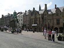
At the base of the peninsula is the Market Place, which still hosts regular markets; a permanent indoor market, Durham Indoor Market, is also situated just off the Market Place. The Market Place and surrounding streets are one of the main commercial and shopping areas of the city. From the Market Place, the Bailey leads south past Palace Green; The Bailey is almost entirely owned and occupied by the university and the cathedral.
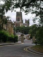
Durham is a hilly city, claiming to be built upon the symbolic seven hills. Upon the most central and prominent position high above the Wear, the cathedral dominates the skyline. The steep riverbanks are densely wooded, adding to the picturesque beauty of the city. West of the city centre, another river, the River Browney, drains south to join the Wear to the south of the city.

The county town of County Durham, until 2009 Durham was located in the City of Durham local government district, which extended beyond the city, and had a total population of 87,656 in 2001, covering 186.68 square kilometres in 2007.[1] In 2001, the unparished area of Durham had a population of 29,091, whilst the built-up area of Durham had a population of 42,939.[39][40][41]
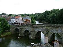
There are three old roads out of the Market Place: Saddler Street heads south-east, towards Elvet Bridge, the Bailey and Prebends Bridge. Elvet Bridge leads to the Elvet area of the city, Durham Prison and the south; Prebends Bridge is smaller and provides access from the Bailey to south Durham. Heading west, Silver Street leads out of the Market Place towards Framwellgate Bridge and North Road, the other main shopping area of the city. From here, the city spreads out into the Framwelgate, Crossgate, Neville's Cross and viaduct districts, which are largely residential areas. Beyond the viaduct lie the outlying districts of Framwellgate Moor and Neville's Cross. Heading north from the Market Place leads to Claypath. The road curves back round to the east and beyond it lie Gilesgate, Gilesgate Moor and Dragonville.
Many of the inner city areas are now inhabited by students living in shared houses.
Historical geography
.jpg)
The historical city centre of Durham has changed little over the past 200 years. It is made up of the peninsula containing the cathedral, palace green, former administrative buildings for the palatine and Durham Castle.[4] This was a strategic defensive decision by the city's founders and gives the cathedral a striking position.[11] So much so that Symeon of Durham stated:
"To see Durham is to see the English Sion and by doing so one may save oneself a trip to Jerusalem"[4]
Sir Walter Scott was so inspired by the view of the cathedral from South Street[42] that he wrote "Harold the Dauntless", a poem about Saxons and Vikings set in County Durham and published on 30 January 1817. The following lines from the poem are carved into a stone tablet on Prebends Bridge:
Grey towers of Durham
Yet well I love thy mixed and massive piles
Half church of God, half castle 'gainst the Scot
And long to roam those venerable aisles
With records stored of deeds long since forgot.[43]
The old commercial section of the city encompasses the peninsula on three sides, following the River Wear. The peninsula was historically surrounded by the castle wall extending from the castle keep and broken by two gatehouses to the north and west of the enclosure.[2] After extensive remodelling and "much beautification"[2] by the Victorians the walls were removed with the exception of the gatehouse which is still standing on the Bailey.
The medieval city was made up of the cathedral, castle and administrative buildings on the peninsula.[3] The outlying areas were known as the townships and owned by the bishop,[4] the most famous of these being Gilesgate (which still contains the mediaeval St Giles Church), Claypath and Elvet.[2]
The outlying commercial section of the city, especially around the North Road area, saw much change in the 1960s during a redevelopment spearheaded by Durham City Council; however, much of the original mediaeval street plan remains intact in the area close to the cathedral and market place.[2] Most of the mediaeval buildings in the commercial area of the city have disappeared apart from the House of Correction and the Chapel of Saint Andrew, both under Elvet Bridge.[2] Georgian buildings can still be found on the Bailey and Old Elvet[2] most of which make up the colleges of Durham University.
Climate
The table below gives the average temperature, rainfall and sunshine figures taken between 1981 and 2010, and extreme temperatures back to 1850 for the Met Office weather station in Durham:
| Climate data for Durham 102m asl, 1981–2010, extremes 1850– | |||||||||||||
|---|---|---|---|---|---|---|---|---|---|---|---|---|---|
| Month | Jan | Feb | Mar | Apr | May | Jun | Jul | Aug | Sep | Oct | Nov | Dec | Year |
| Record high °C (°F) | 16.7 (62.1) |
17.4 (63.3) |
21.7 (71.1) |
24.1 (75.4) |
27.8 (82) |
30.6 (87.1) |
31.0 (87.8) |
32.5 (90.5) |
30.0 (86) |
25.0 (77) |
19.4 (66.9) |
15.9 (60.6) |
32.5 (90.5) |
| Average high °C (°F) | 6.6 (43.9) |
7.2 (45) |
9.5 (49.1) |
11.9 (53.4) |
15.0 (59) |
17.6 (63.7) |
20.1 (68.2) |
19.8 (67.6) |
17.2 (63) |
13.3 (55.9) |
9.4 (48.9) |
6.7 (44.1) |
12.9 (55.2) |
| Average low °C (°F) | 0.9 (33.6) |
0.9 (33.6) |
2.3 (36.1) |
3.7 (38.7) |
6.1 (43) |
9.0 (48.2) |
11.1 (52) |
11.0 (51.8) |
9.0 (48.2) |
6.3 (43.3) |
3.4 (38.1) |
1.1 (34) |
5.4 (41.7) |
| Record low °C (°F) | −17.2 (1) |
−18.3 (−0.9) |
−15 (5) |
−11.1 (12) |
−4.4 (24.1) |
−1.1 (30) |
1.1 (34) |
0.6 (33.1) |
−1.1 (30) |
−5.5 (22.1) |
−8.8 (16.2) |
−16.6 (2.1) |
−18.3 (−0.9) |
| Average rainfall mm (inches) | 52.3 (2.059) |
41.8 (1.646) |
44.6 (1.756) |
52.7 (2.075) |
44.2 (1.74) |
55.4 (2.181) |
54.0 (2.126) |
60.8 (2.394) |
55.4 (2.181) |
60.9 (2.398) |
72.0 (2.835) |
57.0 (2.244) |
651.1 (25.634) |
| Mean monthly sunshine hours | 58.6 | 80.3 | 115.5 | 150.3 | 181.7 | 164.8 | 172.3 | 167.3 | 134.5 | 102.8 | 66.4 | 51.2 | 1,445.4 |
| Source #1: Met Office[44] | |||||||||||||
| Source #2: NEForum[45][46][47] | |||||||||||||
Like the rest of the United Kingdom, Durham has a temperate climate. At 651.1 millimetres (26 in)[48] the average annual rainfall is lower than the national average of 1,125 millimetres (44 in).[49] Equally there are only around 122 days[48] where more than 1 millimetre (0.04 in) of rain falls compared with a national average of 154.4 days.[49] The area sees on average 1445.4 hours of sunshine per year,[48] compared with a national average of 1125.0 hours.[49] There is frost on 51.5 days[48] compared with a national average of 55.6 days.[49] Average daily maximum and minimum temperatures are 12.5 °C (54.5 °F) and 5.2 °C (41.4 °F)[48] compared with a national averages of 12.1 °C (53.8 °F) and 5.1 °C (41.2 °F) respectively.[49] The highest temperature recorded at Durham was 32.5 °C (90.5 °F) during August 1990.[50]
Governance
The ancient borough covering Durham was Durham and Framwelgate and it was reformed by the Municipal Corporations Act 1835. In 1974 it was merged with Durham Rural District and Brandon and Byshottles Urban District to form the City of Durham district of County Durham. The district was abolished in 2009 with its responsibilities assumed by Durham County Council, a unitary authority.
Since April 2009 city status has been held by charter trustees, who are the Durham County Council councillors for the area of the former district. The trustees appoint the Mayor of Durham.[51]
Durham's MP is Roberta Blackman-Woods (Labour).
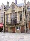
Durham Town Hall, on the west side of the Market Place, is a complex of buildings the earliest part of which dates from 1356. The Guildhall at the front of the building was rebuilt by Bishop Tunstall in 1535, and again by Bishop Cosin in 1665. The 'new' town hall, at the rear, was opened in 1851 (at the same time as the indoor market, which extends beneath and either side of the hall). The latest major refurbishment took place in 2007, and the building continues to be used by the mayoralty and for civic events.
Economy
This is a table of trend of regional gross value added of County Durham at current basic prices published (pp. 240–253) by Office for National Statistics with figures in millions of British Pounds Sterling.
| Year | Regional Gross Value Added[notes 1] | Agriculture[notes 2] | Industry[notes 3] | Services[notes 4] |
|---|---|---|---|---|
| 1995 | 4,063 | 47 | 1,755 | 2,261 |
| 2000 | 4,783 | 40 | 1,840 | 2,904 |
| 2003 | 5,314 | 39 | 1,978 | 3,297 |
Landmarks
The whole of the centre of Durham is designated a conservation area. The conservation area was first designated on 9 August 1968, and was extended on 25 November 1980.[52] In addition to the Cathedral and Castle, Durham contains over 630 listed buildings,[53] 569 of which are located within the city centre conservation area. Particularly notable properties include:
Grade I listed
- Chorister School[54]
- Crook Hall[55]
- Durham Castle
- Durham Cathedral
- Elvet Bridge[56]
- Framwellgate Bridge[57]
- Kepier Hospital
- Kingsgate Bridge[58]
- Prebends Bridge[59]
- St Giles Church, Gilesgate[60]
- Church of St Margaret of Antioch, Crossgate[61]
- Church of St Mary-le-Bow (now Durham Heritage Centre)[62]
- St. John's College Chapel, formerly the Church of St Mary the Less
- St. John's College, Linton House, 1 South Bailey
Grade II* listed

- Aykley Heads House (now Bistro 21)
- Bishop Cosin's Hall, Palace Green
- Cosin's Library (now part of University Library, Palace Green)
- Crown Court, Old Elvet
- St Cuthbert's Society, 12 South Bailey
- St John's College, 3 South Bailey
- St Oswald's Church
- Railway viaduct, North Road
- Town Hall and Guildhall, Market Place
- Durham Marriott Hotel Royal County, Old Elvet
Grade II listed
- Durham Observatory[63]
- The Chapel of the College of St Hild and St Bede
- The Victoria, a public house at 86 Hallgarth Street[64]
- and a great many others[65]
Durham Cathedral
The Cathedral Church of Christ, Blessed Mary the Virgin and St Cuthbert of Durham, commonly referred to as Durham Cathedral was founded in its present form in AD 1093 and remains a centre for Christian worship today. It is generally regarded as one of the finest Romanesque cathedrals in Europe and the rib vaulting in the nave marks the beginning of Gothic ecclesiastical architecture. The cathedral has been designated a UNESCO World Heritage Site[66] along with nearby Durham Castle, which faces it across Palace Green, high above the River Wear.
The cathedral houses the shrine and related treasures of Cuthbert of Lindisfarne, and these are on public view. It is also home to the head of St Oswald of Northumbria and the remains of the Venerable Bede.[66]
Durham Castle
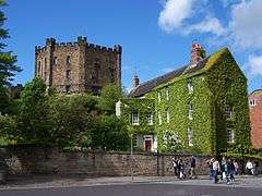
The castle was originally built in the 11th century as a projection of the Norman power in Northern England, as the population of England in the north remained rebellious following the disruption of the Norman Conquest in 1066. It is an excellent example of the early motte and bailey castles favoured by the Normans.[67] The holder of the office of Bishop of Durham was appointed by the King to exercise royal authority on his behalf and the castle was the centre of his command.
It remained the Bishop's Palace for the Bishops of Durham[68] until the Bishop William Van Mildert made Bishop Auckland their primary residence. A founder of Durham University, Van Mildert gave the castle as accommodation for the institution's first college, University College.[69] The castle was famed for its vast Great Hall, created by Bishop Antony Bek in the early 14th century. It was the largest great hall in Britain until Bishop Richard Foxe shortened it at the end of the 15th century. However, it is still 46 feet high and over 33 yards long. The castle is still the home of University College, Durham (which is, as a result, known informally as "Castle"). It has been in continuous use for over 900 years and is the only castle in the United Kingdom never to have suffered a breach.
Education
Durham University
Durham is home to Durham University. It was founded as the University of Durham (which remains its official and legal name)[70] by Act of Parliament in 1832 and granted a Royal Charter in 1837. It was one of the first universities to open in England for more than 600 years, and is claimed to be England's third oldest after the Universities of Oxford and Cambridge. Durham University has an international reputation for excellence, as reflected by its ranking in the top 100 of the world's universities.[71]
Further education
New College Durham is the city's largest college of further education. It was founded in 1977 as a result of a merger between Neville's Cross College of Education and Durham Technical College. The college operated on two main sites near the city of Durham: Neville's Cross and Framwellgate Moor. The site at Framwellgate Moor opened in 1957 and has subsequently been rebuilt. The Neville's Cross Centre, which used to be housed in the county's former asylum has been sold for development into houses.
Durham Sixth Form Centre specialises in sixth form courses, while East Durham College has sites just to the east of the city.
Schools
The results relate to the 2008 examination series.
Secondary schools
Durham is served by five state secondary schools:
| School | GCSE Results (percentage A* to C) | [72] A/AS Average points[72] |
|---|---|---|
| Belmont School Community and Arts College[73] | 48% | N/A |
| Durham Gilesgate Sports College + 6th Form Centre[74] | 26% | 766.1 |
| Durham Johnston Comprehensive School[75] | 73% | 853.1 |
| Framwellgate School Durham[76] | 77% | 645.8 |
| St Leonard's Catholic School[77] | 65% | 751 |
Independent schools
There are three independent schools:
| School | GCSE Results (percentage A* to C) | [72] A/AS Average points[72] |
|---|---|---|
| The Chorister School | N/A | N/A |
| Durham High School for Girls | 98% | 854.8 |
| Durham School | 76% | 807.1 |
Primary schools
Primary schools include:
- Finchale Primary School
- Durham Blue Coat Junior School[78]
- Durham Gilesgate Primary[79]
- St Joseph's RCVA Primary[80]
- St Godric's RC Primary School
- St Margaret's CofE Primary School[81]
- St Oswald's CofE Infant School[82]
- Nevilles Cross Primary School
- St Hild's College CE Aided Primary School
Transport
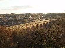
Durham railway station is situated on the East Coast Main Line between Edinburgh and London; rail travellers coming from the south enter Durham over a spectacular Victorian viaduct high above the city. By road, the A1(M), the modern incarnation of the ancient Great North Road, passes just to the east of the city. (Its previous incarnation, now numbered A167, passes just to the west.) Newcastle Airport lies to the north and Durham Tees Valley Airport to the south, both being about 25 miles (40 km) away. The Market Place and peninsula form the UK's first (albeit small) congestion charging area, introduced in 2002.[83]
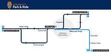
Durham County Council operate a bus-based park and ride service to the city centre from three sites on the periphery of the city. The service operates every 10 minutes Monday to Saturday between 7am and 7pm.
Durham bus station
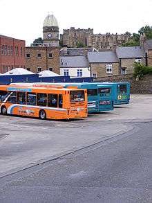
Durham bus station serves the city of Durham. The bus station is managed by Durham County Council. There are 11 stands and the main operators from the bus station are Go North East, Arriva North East,Scarlet Band, Stanley Travel, Weardale Motor Services and National Express.
Sport
Archery
Durham Hosts several archery clubs who shoot at various locations in the city,[84][85][86] members of these clubs shoot for the region and individually at national events, as well as many who shoot purely for fun. In 2014 the regional Durham And Northumberland Archery Team won the National Intercounty Team Event at Lilleshall NSC, this event saw 260 archers from 19 counties competing over 2 days for the title.[87]
Cricket
Durham City Cricket Club plays on its own ground near the River Wear. Formed in 1829, Durham City was one of the founder members of the Durham Senior Cricket League upon its creation in 1903 and the First XI have been crowned champions on thirteen occasions.[88]
Football
The town's football club Durham City A.F.C. once boasted membership of the Football League between 1921 and 1928 but has long been a non-league club, currently playing in the Northern League. Their home ground is New Ferens Park, known as the Arnott Stadium for sponsorship reasons.
Durham is also home to, Women's Super League 2 team, Durham Women's F.C., a team founded in 2014 and owned by Durham University. The team, nicknamed The Wildcats, groundshare with Durham City A.F.C. at New Ferens Park.
Ice rink
Durham Ice Rink was a central feature of the city for some 60 years until it closed in 1996. It was home to the Durham Wasps, one of the most successful British ice hockey clubs during the 1980s and early 1990s. In 2009 an ice rink opened outside of the bowling alley it lasted for 6–8 months.
Durham Ice Rink's demolition began in May 2013.[89] On the location of the former ice rink now stands Freemans Reach which houses the Durham Passport Office[90]
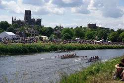
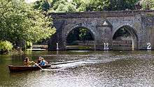
Rowing
The River Wear provides some 1800 m[91] of river that can be rowed on, stretching from Old Durham Beck in the east (54°46′21.49″N 1°33′26.75″W / 54.7726361°N 1.5574306°W) to the weir next to Durham School Boat Club's boat house in the west (54°46′20.95″N 1°34′45.35″W / 54.7724861°N 1.5792639°W). This includes the 700 m straight used for most of the Durham Regatta races and some challenging navigation through the arches of Elvet Bridge, reputed to be the narrowest row through bridge in Europe,[92] and the bends of the river round the peninsula. There is a path running alongside the river's south bank (i.e. the Cathedral side) for the entire length of the stretch available for rowing, the concrete section between Hatfield College boathouse and Elvet Bridge being completed in 1882.[93][94]
For sport rowing there are a number of boating clubs operating on this stretch, Durham Amateur Rowing Club, the Durham University Boat Club, the 14 university college clubs of the Durham campus, Durham Constabulary and the school clubs – Durham School Boat Club and St Leonard's who row regularly in their own colours out of their own boat houses and Durham High School for Girls who may row out of Durham Amateur Rowing Club.
Durham Amateur Rowing Club
| Durham Amateur Rowing Club | |
|---|---|
 | |
 | |
| Location | Durham |
| Coordinates | 54°46′25.6″N 1°33′26.83″W / 54.773778°N 1.5574528°W |
| Home water | River Wear |
| Founded | 1860 |
| Website |
durham-arc |
| Events | |
| |
Durham Amateur Rowing Club, DARC, operates out of a purpose built community clubhouse on the River Wear which opened in 2007:[95]
Durham Amateur Rowing Club is one of the country's oldest clubs (founded in 1860) and lies at the end of Green Lane in Durham, occupying a tranquil setting on the River Wear.[96]
The club takes part in the government scheme playing for success where it uses sport to combine rowing, science, computers and video to help boost literacy and numeracy.[97]
Durham University rowing
Durham University rowing is divided into two sections: Durham University Boat Club and Durham College Rowing, the latter comprises 16 college boat clubs.
Regattas and head races
The River Wear is host to a number of regattas and head races throughout the year. These include:
the Novice Cup, Wear Long Distance Sculls and Senate Cup in November and December; Durham Small Boats Head in February; Durham City Regatta in May; Durham Regatta and Admiral's Regatta in June; and Durham Primary Regatta in September.[92]
Durham Regatta
Durham Regatta has been held on the River Wear in Durham since 1834. It is the second oldest regatta in Britain[98] and is often referred to as 'the Henley of the North'.[99]
Durham Regatta in its current form dates back to 1834, when only a handful of trophies were competed for over a period of three days. Today, the regatta takes place over a period of two days, at which dozens of trophies are competed for. It is a favourite amongst Durham University, Durham School and Durham Amateur Rowing Club, who have competed regularly since the early days.[100]
Pleasure boats
In addition to the competitive rowing and sculling of the boat clubs mentioned above, there is also a thriving hire of public pleasure boats from April to October.[101]
Rugby
Durham City Rugby Club has its headquarters on Green Lane:
Durham City RFC, the second oldest club in the county, was founded in 1872 with navy and gold playing colours and Durham Cathedral's sanctuary knocker as the club's crest.City have a proud heritage and their Hollow Drift home has been developed into an excellent rugby facility which includes two floodlit pitches and a training area.
At present, City run four senior sides, a Veteran's XV, a Ladies' XV and mini and junior teams from aged 6 to 17.[102]
Durham University sport
Notable people
- Rowan Atkinson, (born in Consett in 1955), actor. Attended the Chorister School 1964–1966.[103]
- Matt Baker, (born in 1977), British TV presenter for the BBC. shows include Blue Peter, the one show and Countryfile.
- Pat Barker, (born in Thornaby on Tees in 1943), novelist ('Regeneration' trilogy), now resident in Durham.[104]
- Barnabe Barnes, (baptised 1571, died 1609), Elizabethan poet. Died in Durham.[105]
- Tony Blair, (born 1953) former Prime Minister of the United Kingdom. Attended the Chorister School 1961–1966.[103]
- Count Joseph Boruwlaski (1739–1837), dwarf, spent last years of his life in Durham.[106]
- Rev. Edward Bradley (1827–1889). Studied at Durham University and took his nom de plume "Cuthbert Bede" from the names of two its colleges.[107]
- Richard Caddel (1949–2003), poet. Lived in Durham from the 1970s and was co-director of the Basil Bunting poetry centre at Durham University library from 1988.[108]
- George Camsell (1902–1966), international footballer, born in Framwellgate Moor.[109]
- Paul Collingwood (born 1976), international cricketer. Born in Shotley Bridge, now resident in Durham.[110]
- Sir Kingsley Dunham (1910–2001), Professor of Geology and later Professor Emeritus at the University of Durham, director of the British Geological Survey from 1967–75.[111]
- John Bacchus Dykes (1823–1876), hymnologist, clergyman in Durham from 1849 to his death.[112]
- John Meade Falkner (1858–1932), arms manufacturer and novelist. Lived in Durham from 1902, and became Honorary Reader in Paleography at the University of Durham, and Honorary Librarian to the Dean and Chapter Library of Durham Cathedral.[113]
- James Fenton (born 1949), journalist and poet. Attended the Chorister School 1957–1962.[103]
- Max Ferguson (born 1924), Canadian broadcaster, born in Durham.[114]
- John Garth (1721–1810), composer. Lived in Durham for much of his life.[115]
- Godric of Finchale (c. 1065–1170), popular medieval saint, briefly served as doorkeeper at St Giles Hospital in Durham before becoming a hermit.[116]
- Andy Gomarsall (born 1974), International rugby union player. Born in Durham.[117]
- John Gully (1783–1863), prize fighter, racehorse owner and politician. Resident in Durham at time of his death.[118]
- Warren Hawke (born 1970), professional footballer
- Ian Hay, novelist (taught at Durham School)
- Lorna Hill, children's writer
- Trevor Horn, record producer and member of the Buggles and Art Of Noise, born in Durham 1949.[119]
- Steve Howard, professional footballer
- Violet Hunt, novelist
- Cyril Edwin Mitchinson Joad, philosopher and radio broadcaster
- Stephen Kemble of the famous British acting family, the Kemble family lived, worked and is buried in Durham.
- Lawrence of Durham (died 1154), poet
- Sir John Grant McKenzie Laws, Lord Justice Laws, judge (attended the Chorister School[103])
- Paddy McAloon, musician, born in Durham in 1957
- Thomas Morton, playwright.
- Pauline Murray (born 1958), lead-singer with punk-band Penetration and solo artist during the 1980s
- Stuart Parnaby, former Middlesbrough player now playing for Hartlepool
- Anna Maria Porter, novelist
- Jane Porter, novelist
- Michael Ramsey, 100th Archbishop of Canterbury (a former Bishop of Durham)
- Reginald of Durham (died c. 1190), hagiographer
- Gordon Scurfield, biologist and author
- Christopher Smart, poet
- Joseph Spence, literary memoirist
- Anne Stevenson, poet
- Mary Stewart (novelist and poet), born in Sunderland, graduated from Durham University and was a lecturer there in English Literature (author of 20 novels, including The Moonspinners, Madam Will You Talk, and the Merlin trilogy)
- Robert Surtees, historian and antiquarian
- Symeon of Durham (died after 1129), historian
- Sir Peter Vardy, businessman (attended the Chorister School[103])
- Sir Hugh Walpole, novelist
- Walter of Durham (died c. 1305), 13th century painter and carpenter to Henry III and Edward I
- Sir Arnold Wolfendale, Astronomer Royal
- James Wood, literary critic
Twin towns
 Durham, North Carolina, United States
- Durham, Connecticut, United States
- Durham, New Hampshire, United States
 Tübingen, Germany
- Kreis Wesel, Germany
 Kostroma, Russia
 Department of the Somme, France
 Banska Bystrica, Slovakia
 Nakskov, Denmark
 Alcala de Guadaira, Spain
 Jászberény, Hungary
See also
- Lord Lieutenant of Durham
- List of Deputy Lieutenants of Durham
- List of High Sheriffs of Durham
- St Nicholas' Church, Durham
- North East England
Notes
- ↑ Components may not sum to totals due to rounding
- ↑ includes hunting and forestry
- ↑ includes energy and construction
- ↑ includes financial intermediation services indirectly measured
References
- 1 2 "Standard Area Measurements for Statistical Outputs for Geographies in the United Kingdom as at 31 December 2007". Office for National Statistics. August 2009. Retrieved 23 December 2009.
- 1 2 3 4 5 6 7 8 9 10 11 12 13 14 15 Surtees, R. (1816) History and Antiquities of the County Palatine of Durham (Classical County Histories)
- 1 2 3 4 5 6 7 8 9 10 11 12 13 Liddy, Christian D (2008). The Bishopric of Durham in the Late Middle Ages: Lordship, Community and the Cult of St. Cuthbert. Boydell Press. ISBN 978-1-84383-377-2.
- 1 2 3 4 5 6 Symeon of Durham, Libellus de exordio atque procurso istius, hoc est Dunhelmensis (Tract on the origins and progress of this the church of Durham)
- 1 2 3 4 5 6 Dufferwiel, Martin (2004/1996). Durham: Over 1,000 Years of History and Legend. Edinburgh: Mainstream Publishing. ISBN 9781840189148. Chapter 1, "Beginnings".
- ↑ Fowler, Joseph Thomas (1891). "Preface", in Fowler (Ed.), The Life of St. Cuthbert in English Verse, C. A.D. 1450: From the Original Ms. in the Library at Castle Howard. Publications of the Surtees Society, vol. 87. Durham: Andrews & Co., for the Society. p. xi.
- ↑ Crook, John (2000). The Architectural Setting of the Cult of Saints in the Early Christian West, c. 300–c. 1200. Oxford: Clarendon Press. ISBN 9780198207948. p. 167.
- ↑ Missale Romanum (Roman missal)
- ↑ The Lives of the Saints as contained in the "New English Missal"
- ↑ Durham Cathedral Illustrated Guide (available from the Cathedral Bookshop)
- 1 2 3 4 Richardson, Michael (2007). Durham City: Past & Present. Breedon Books Publishing Co Ltd. ISBN 978-1-85983-581-4.
- ↑ Brown, Nicholas (1931) Durham Castle
- ↑ The Forms of Precidents of the Catholic Church as contained in the Catholic Encyclopaedia (1919)
- ↑ As stated in Liddy, Christian D. (2008) The Bishopric of Durham in the Late Middle Ages: Lordship, Community and the Cult of St. Cuthbert. The attribution of the quote is questionable (see County Palatine); however, the editor of this article is almost certain it is attributable to Antony Bek's steward.
- ↑ "hansard.millbanksystems.com/lords/1836/jun/10/bishopric-of-durham".
- ↑ Whiehead, Alan Mary Ann Cotton: Dead but not forgotten (Durham Records Office: 2004)
- 1 2 3 4 (1798) Noble, Mark: The Lives of the English Regicides: And Other Commissioners of the Pretended High Court of Justice, Appointed to Sit in Judgment Upon Their Sovereign, King Charles the First
- 1 2 The Society of Charles the King and Martyr: Newsletter (12)
- ↑ Deary, Terry (2001). Deadly Durham. County Durham Books. ISBN 978-1-897585-64-1.
- ↑ Durham Cathedral Guidebook (available from the cathedral)
- ↑ http://www.durham.ac.uk (see University College homepage)
- ↑ Simpson, David. "Market Place, Silver Street and Saddler Street (Durham City)". Retrieved 23 July 2009.
- ↑ Blake, D. (1998) The North East
- ↑ The Great Reform Act, 1832
- ↑ The Representation of the People Act 2000
- ↑ The Canons of the Church of England
- ↑ The Proceedings of the Court of Claims at the Coronation of Her Majesty Elizabeth II
- ↑ The Census
- ↑ The Proceedings of the High Court of Justice 1995
- 1 2 3 Simpson, David (2006). Durham City. Business Education Publishers Ltd. ISBN 978-1-901888-50-8.
- ↑ Nixon, P: A Portrait of Durham
- ↑ Frith, Francis: Durham: A Miscellany (Did You Know?)
- ↑ The Durham University Act, 1882 and the Royal Charter for the Founding of the University of Durham
- 1 2 3 Dufferwiel, Martin (1996). Durham: A Thousand Years of History and Legend. Edinburgh and London: Mainstream Publishing. p. 173. ISBN 1 85158 885 X.
- 1 2 Pevsner, Nikolaus; Williamson, Elizabeth (1985). The Buildings of England: Durham. Yale University Press. pp. 231–249. ISBN 978 0 300 09599 9.
- ↑ Cherry, Simon (2 September 2012). "WHO SAID ANYTHING ABOUT SAFE? A TALE OF TWO CATHEDRALS: DURHAM AND COVENTRY". www.durhamcathedral.co.uk. Durham Cathedral. Retrieved 3 November 2016.
- ↑ "Fogscape #03238". Retrieved 3 November 2016.
- ↑ Centre, UNESCO World Heritage. "Durham Castle and Cathedral". whc.unesco.org. Retrieved 2016-11-03.
- ↑ "Census 2011: Durham". 2011 Census. Office for National Statistics. Retrieved 28 May 2015.
- ↑ "2001 Census Summary Sheet Indicators for County Durham Parish Boundaries" (PDF). Durham County Council. Retrieved 23 December 2009.
- ↑ Census 2001: Key Statistics for Urban Areas in the North (PDF). London: Office for National Statistics. 2000. p. 54. ISBN 0-11-621744-8. Retrieved 23 December 2009.
- ↑ Buchan, John (1932). "Sir Walter Scott". Cassell.
- ↑ Scott, Walter (1817). "Harold the Dauntless". James Eastburn & co.
- ↑ "Durham climate information". Met Office. 1981–2010. Retrieved 11 August 2015.
- ↑ NEForum
- ↑ http://www.metoffice.gov.uk/climate/uk/interesting/december2015_temperature
- ↑ http://www.metoffice.gov.uk/media/pdf/r/4/State_of_the_UK_climate_2015.pdf
- 1 2 3 4 5 Durham 1971–2000 averages, Met Office. Retrieved on 20 August 2007.
- 1 2 3 4 5 UK 1971–2000 averages, Met Office. Retrieved on 20 August 2007.
- ↑ "1990 temperature". Durham University.
- ↑ Durham County Council Charter Trust
- ↑ "Conservation areas". Archived from the original on 24 December 2008.
- ↑ "City of Durham – Local Plan".
- ↑ "Chorister School". Heritage Gateway. Retrieved 26 September 2009.
- ↑ "Crook Hall". Heritage Gateway. Retrieved 26 September 2009.
- ↑ "Elvet Bridge". Heritage Gateway. Retrieved 26 September 2009.
- ↑ "Framwellgate Bridge". Heritage Gateway. Retrieved 26 September 2009.
- ↑ "Kingsgate Bridge". Heritage Gateway. Retrieved 26 September 2009.
- ↑ "Prebends Bridge". Heritage Gateway. Retrieved 26 September 2009.
- ↑ "Church of St Giles". Heritage Gateway. Retrieved 26 September 2009.
- ↑ "Church of St Margaret of Antioch". Heritage Gateway. Retrieved 26 September 2009.
- ↑ "St Mary Le Bow Heritage Centre". Heritage Gateway. Retrieved 26 September 2009.
- ↑ "Durham Observatory". Heritage Gateway. Retrieved 3 October 2009.
- ↑ Historic England. "The Victoria, Durham (1381263)". National Heritage List for England. Retrieved 19 August 2014.
- ↑ Good Stuff IT Services. "Listed Buildings in Durham, Durham, England - British Listed Buildings". British Listed Buildings.
- 1 2 "Durham Castle and Cathedral – UNESCO World Heritage Centre".
- ↑ Durham Castle. "Britain Express". Retrieved 23 January 2009.
- ↑ Durham Castle. "Sacred-destinations". Retrieved 23 January 2009.
- ↑ Durham Castle. "History of Durham Castle". Retrieved 23 January 2009.
- ↑ "The University : Trading Name – Durham University".
- ↑ "The World University Rankings". Retrieved 15 January 2016.
- 1 2 3 4 "Secondary schools in Durham". London: BBC. 15 January 2009. Retrieved 26 September 2009.
- ↑ "Belmont School Community and Arts College". Durham County Council. Retrieved 26 September 2009.
- ↑ "Durham Gilesgate Sports College + 6th Form Centre". Durham County Council. Retrieved 26 September 2009.
- ↑ "Durham Johnston Comprehensive". Durham County Council. Retrieved 26 September 2009.
- ↑ "Framwellgate School Durham". Durham County Council. Retrieved 26 September 2009.
- ↑ "St Leonard's Catholic". Durham County Council. Retrieved 26 September 2009.
- ↑ "Durham Blue Coat CofE (Aided) Junior". Durham County Council. Retrieved 26 September 2009.
- ↑ "Durham Gilesgate Primary". Durham County Council. Retrieved 26 September 2009.
- ↑ "St Joseph's RCVA Primary". Durham County Council. Retrieved 26 September 2009.
- ↑ "Durham St Margaret's CofE Primary". Durham County Council. Retrieved 26 September 2009.
- ↑ "St Oswald's C.E. Aided Infant and Nursery". Durham County Council. Retrieved 26 September 2009.
- ↑ Wilson, Bill (11 February 2003). "Spotlight on Durham's charge". BBC News.
- ↑ "Durham City Archers". durhamcityarchers.org.
- ↑ "Home - St. Giles Archers". saintgilesarchers.co.uk.
- ↑ "Durham UniversityArchery Club - Home". Durham University
Archery Club. - ↑ "Counties go head-to-head". archerygb.org.
- ↑ "Durham City Cricket Club". Durham City Cricket Club. Retrieved 26 September 2009.
- ↑ http://www.durhamtimes.co.uk/news/10396246.End_of_an_era_as_Durham_Wasps__rink_demolition_begins/?ref=rss
- ↑ "Find a Passport Customer Service Centre - GOV.UK". www.gov.uk. Retrieved 2016-11-09.
- ↑ "Thousands enjoy city's big day". Northern Echo. 15 June 2007. Retrieved 27 September 2009.
- 1 2 "River Wear". Durham College Rowing. Retrieved 27 September 2009.
- ↑ Macfarlane-Grieve, Captain A.A., ed. (1922). A History of Durham Rowing. Newcastle-upon-Tyne: Andrew Ried and Company, Limited. p. 53.
This year 1882 also was constructed a new concrete path between the Hatfield Hall boathouse and Elvet Bridge. Rowing men are indebted to the Rev. W.A. Fearon, at that time headmaster of Durham School, for this improvement. Before this date it had been necessary for those running with the boats to cross the river at Elvet Bridge, and the proceed by way of New Elvet to the river bank at St. Oswald's Church, which made coaching from the bank a much more difficult undertaking than it is at present.
- ↑ Macfarlane-Grieve, Captain A.A., ed. (1922). A History of Durham Rowing. Newcastle-upon-Tyne: Andrew Ried and Company, Limited. p. 189.
At a meeting held in March, 1884, the Honorary Secretary of Durham Amateur Rowing Club was instructed to forward a vote of thanks from the officers and members of the club to the Rev. W.A. Fearon, M.A., headmaster of Durham School, for his great generosity in building the wall and constructing a footpath below Hatfield Hall and connecting Elvet Waterside with that part of the banks known as Bow Corner. Present rowing men can hardly realise what the conditions were, both for coaching and following the long course races, before this useful walk was completed. Residents, other than those interested in rowing, have certainly reaped the benefit of this convenient and pleasent walk along the river.
- ↑ "Rowing: We're rowing and growing; New £1 m clubhouse for Durham". Evening Chronicle (Newcastle, England). 12 September 2007. Retrieved 26 September 2009.
- ↑ "Durham Amateur Rowing Club". Durham Amateur Rowing Club. Retrieved 26 September 2009.
- ↑ Tallentire, Mark (15 September 2007). "Classroom opened at rowing club". Northern Echo. Retrieved 27 September 2009.
- ↑ "City ready for weekend of boats, cars and brilliance". Northern Echo. 15 June 2007. Retrieved 27 September 2009.
- ↑ "Durham Bids to be UK City of Culture 2013: The North East's Best Kept Cultural Secret". artdaily.org. Retrieved 26 September 2009.
- ↑ "Durham Regatta". Durham Regatta. Retrieved 26 September 2009.
- ↑ "Browns Rowing Boats". Durham Prince Bishop River Cruiser. Retrieved 27 September 2009.
- ↑ "About Durham City Rugby Club". Durham City Rugby Club. Archived from the original on 10 March 2009. Retrieved 26 September 2009.
- 1 2 3 4 5 "Life After Choristers". The Chorister School. Archived from the original on 29 November 2009. Retrieved 23 December 2009. The Chorister School
- ↑ "Pat Barker". British Council Literature. British Council. Retrieved 26 January 2016.
- ↑ John D. Cox (2004). "Barnes, Barnabe (bap. 1571, d. 1609)". Oxford Dictionary of National Biography. Oxford University Press. Retrieved 17 December 2009.
- ↑ "Durham Town Hall". BBC Wear. BBC. Retrieved 23 December 2009.
- ↑ "Obituary". The Times. 13 December 1889. p. 5.
- ↑ Paul Taylor (18 April 2003). "Obituary: Richard Caddel". The Guardian. London.
- ↑ John Simkin. "George Camsell". Spartacus Educational. Archived from the original on 15 March 2010. Retrieved 23 December 2009.
- ↑ Andrew Miller (October 2009). "Paul Collingwood". Cricinfo. ESPN. Retrieved 23 December 2009.
- ↑ Tony Johnson (16 April 2001). "Obituary: Sir Kingsley Dunham". The Independent. London.
- ↑ "Dykes or Dikes, John Bacchus (DKS843JB2)". A Cambridge Alumni Database. University of Cambridge.
- ↑ "Biography". The John Meade Falkner Society. Archived from the original on 5 July 2008. Retrieved 23 December 2009.
- ↑ Jerry Fairbridge (August 2002). "Ferguson, Max (1924– )". Canadian Communications Foundation. Retrieved 23 December 2009.
- ↑ "John Garth's Cello Concertos". Divine Art Recordings Group. Archived from the original on 4 March 2010. Retrieved 23 December 2009.
- ↑ Butler, Alban; Farmer, David Hugh (1996). Butler's Lives of the Saints. 5. Continuum International Publishing Group. p. 112. ISBN 0-86012-254-9.
- ↑ "Andy Gomarsall". London Wasps. Retrieved 23 December 2009.
- ↑ "The Parish of St Mary the Less – Residents: John Gully 1783–1863". University of Durham. August 2007. Retrieved 23 December 2009.
- ↑ "Trevor Horn". trevorhorn.com. November 2004. Retrieved 25 April 2010.
Flora and fauna
- Bowey, K. and Newsome, M., ed. (2012). The Birds of Durham. Durham Bird Club. ISBN 978-1-874701-03-3
External links
| Wikimedia Commons has media related to Durham. |
| Wikivoyage has a travel guide for Durham. |
Media
North East England Portal | |
| Unitary authorities | |
| Major settlements |
|
| Topics | |